Much of Fukagawa did not exist until people manufactured the land—and then filled it with canals, timber rafts, pilgrims, warehouses and some of Edo’s most spectacular festivals.
Today, Fukagawa can look like several unrelated parts of Tokyo. Monzen-nakacho is crowded with worshippers and restaurants. Kiyosumi-shirakawa is known for gardens, galleries and coffee roasters. Kiba Park occupies broad green space where the timber trade once dominated the waterways. Along the Sumida River, monumental bridges recall the reconstruction that followed the Great Kanto Earthquake.
The connection is water—and the human effort required to control it. Fukagawa grew on delta lowlands east of the Sumida River, where marshes, tidal flats and shallow water were drained, embanked and reclaimed in stages. Canals made the new land usable and then became its transport system. They attracted timber yards, wharves, warehouses, factories and temple towns. When those industries moved or disappeared, the same parcels and buildings became parks, housing, studios and new commercial districts.
Fukagawa is therefore not a preserved fragment of old Edo. It is an artificial landscape repeatedly rebuilt by commerce, religion, disaster and redevelopment. Its modern cafés and promenades make the most sense when seen as the latest use of land first engineered for water transport and heavy work.
Quick Facts
- Japanese name: 深川
- Municipality: Koto City, Tokyo
- Main access: Monzen-nakacho, Kiyosumi-shirakawa and Kiba stations
- Known for: Tomioka Hachiman Shrine, Fukagawa Fudo-do, Kiba, Kiyosumi Gardens, canals and warehouse reuse
- Key landscape: reclaimed lowlands east of the Sumida River
- Major historical forces: reclamation, canals, religious crowds, timber, wholesale trade, earthquake reconstruction, wartime destruction and adaptive reuse
Why Fukagawa Became What It Is Today
Fukagawa developed through a chain of practical decisions. Reclaimed land needed drainage channels. Those channels could carry boats. Boat access attracted businesses handling heavy goods. Temples and shrines drew visitors, who supported food stalls, shops and entertainment. Merchant wealth created estates and gardens. Later factories reused the same waterside advantages.
In the twentieth century, railways and trucks reduced the importance of canal transport. Timber storage moved to larger reclaimed sites farther south. Earthquake and war destroyed much of the earlier built environment. Former industrial land then became parks, apartments, museums, offices and cafés. The district’s present diversity is the result of these overlapping systems rather than one continuous “old Tokyo” atmosphere.
The Lowlands East of the Sumida River
Before intensive development, the land east of the Sumida was a shifting delta of marshes, tidal flats, channels and patches of firmer ground. Rivers deposited sediment while tides and storms repeatedly changed the shoreline. The district was not reclaimed in one grand project. Different areas were opened, drained and filled at different times by village developers, merchants, landowners and the shogunate.
Koto City connects the early modern development of Fukagawa with Fukagawa Hachiroemon, who opened new fields in the Keicho era and established Fukagawa Village. Later projects expanded the usable ground toward Edo Bay. Some reclamation initially created farmland; other projects supported town lots, warehouses, temples, timber yards and industry.
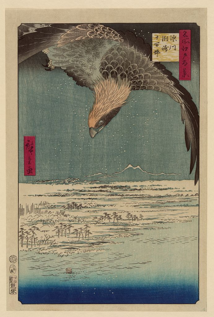
Hiroshige’s view of Susaki and Jumantsubo emphasizes the exposed character of reclaimed lowland beside open water. It is an artistic composition, not a survey map, but it captures the environmental reality that made embankments and drainage essential.
Canals as Streets, Drains and Industrial Infrastructure
Fukagawa’s waterways performed several roles at once. They drained low land, linked the district with the Sumida River and Edo Bay, moved cargo and divided the city into long blocks. Businesses could face a road at the front and receive goods by boat at the rear.
The canals were built and altered over different periods. Some followed natural channels; others were cut through reclaimed land. Their banks held wharves, warehouses, lumber yards and factories. Bridges became essential neighborhood connectors and often gave local areas their identity.
Water also created danger. High tides, river floods, heavy rain and storm surges threatened the lowlands. Modern gates, pumps, embankments and flood-control systems belong to the same long history as the Edo canals.
The Great Fire and Edo’s Expansion Eastward
The Great Fire of Meireki in 1657 accelerated the movement of people and institutions beyond the crowded center of Edo. Estates and temples were relocated, bridges and roads improved, and the eastern districts of Honjo and Fukagawa became more closely integrated with the city.
This expansion was not simply residential. The new lowlands absorbed functions that needed space and water access: timber storage, warehouses, transport yards, religious precincts and later industry. Fukagawa became both a working edge of Edo and a popular destination for worship and leisure.
Tomioka Hachiman Shrine and Monzen-nakacho
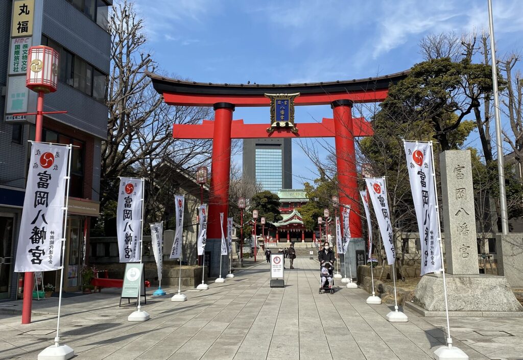
Tomioka Hachiman Shrine was founded in the seventeenth century on developing reclaimed land known as Eitai-jima. As the eastern city grew, the shrine became a major religious center. Worshippers arriving from nearby neighborhoods and across the Sumida supported a commercial district along its approach.
The name Monzen-nakacho literally refers to the town before a religious gate. Shops, food sellers, teahouses and entertainment benefited from festivals and regular visits. The modern station district continues this concentration of movement, although its buildings and street frontages have been repeatedly rebuilt.
The Fukagawa Festival
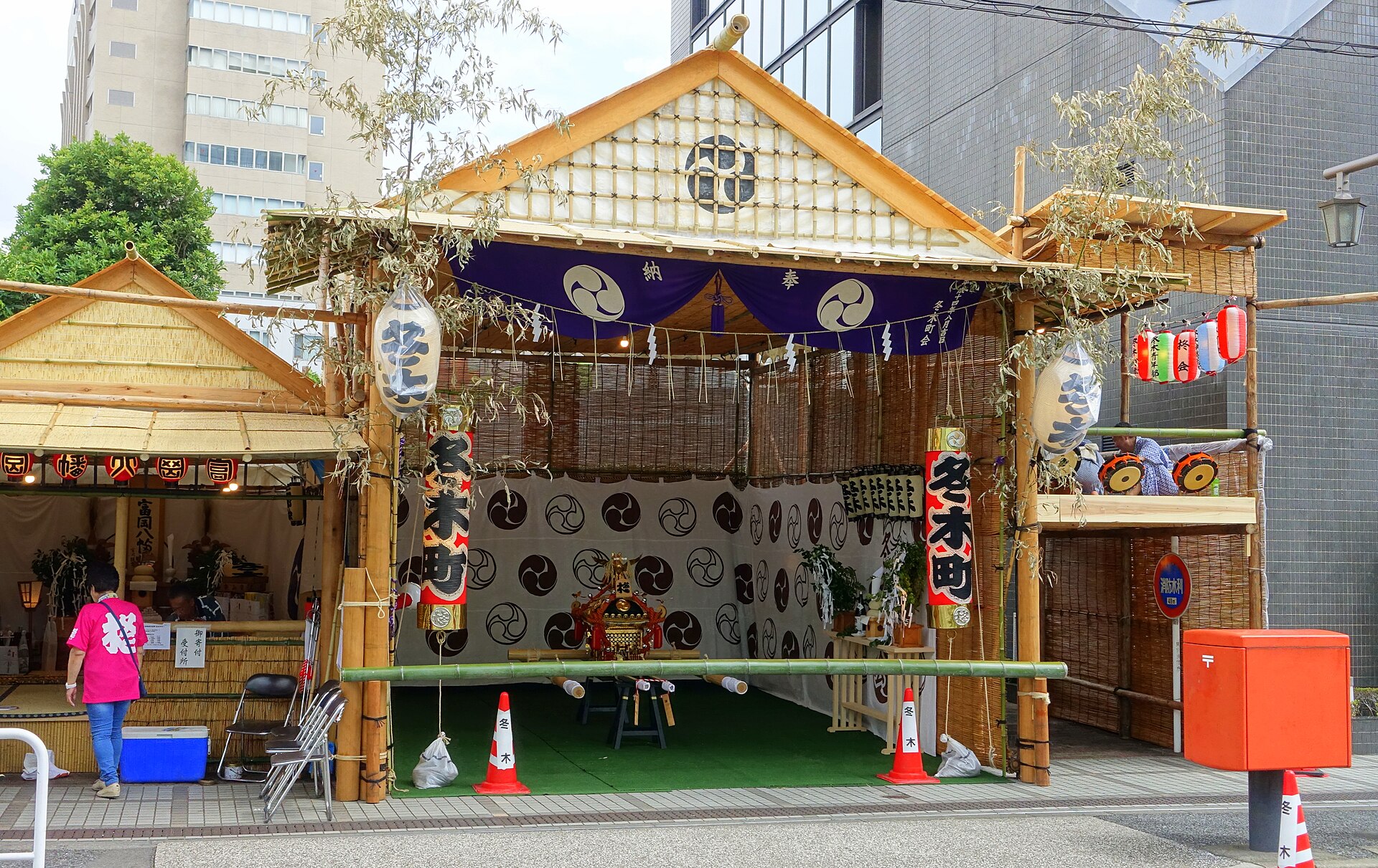
The Fukagawa Hachiman Festival is famous for water thrown over portable shrines and their bearers. The spectacle is produced not by the shrine alone but by networks of parish neighborhoods, associations, donors, volunteers and spectators.
The festival reveals how worship organized urban society. Participating neighborhoods affirmed their relationship with the shrine and with one another. Routes and numbers of portable shrines change by festival cycle, but the combination of water, summer heat, purification and collective performance remains central.
Fukagawa Fudo-do and Pilgrimage without the Journey
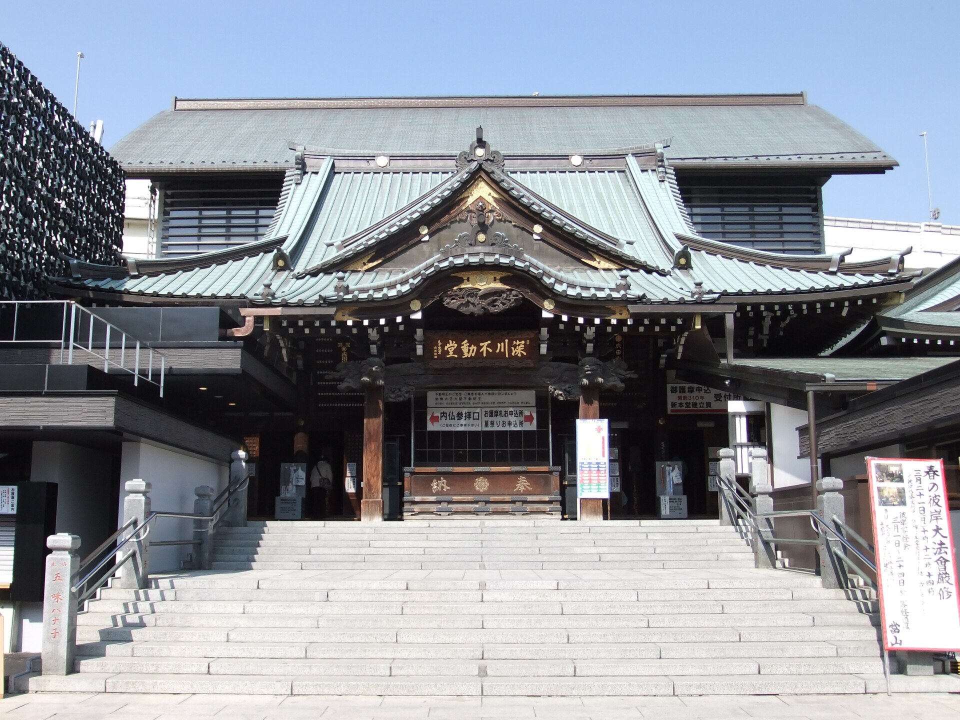
Fukagawa Fudo-do grew from the popularity of Naritasan Shinshoji in present-day Chiba Prefecture. Beginning in 1703, special exhibitions brought its sacred image of Fudo Myoo to Fukagawa. Edo residents could worship without completing the longer journey to Narita.
Repeated exhibitions attracted large crowds and established a permanent pilgrimage economy. A permanent temple was created in the Meiji period. Its present buildings belong to several periods of reconstruction, but the institutional connection with Naritasan and the commercial approach remain active.
Why Timber Came to Kiba
Edo consumed enormous quantities of wood. Houses, bridges, temples, shops and warehouses all required timber, and frequent fires repeatedly created urgent rebuilding demand. Logs were too bulky to move efficiently through crowded streets, so merchants relied on rivers and canals.
Timber storage was first concentrated near Eitai-jima after the Great Fire of Meireki. In 1701, the main yards moved to the area that became known as Kiba, literally “timber place.” Protected waterways allowed logs to be floated, sorted and stored close to the city’s construction market.
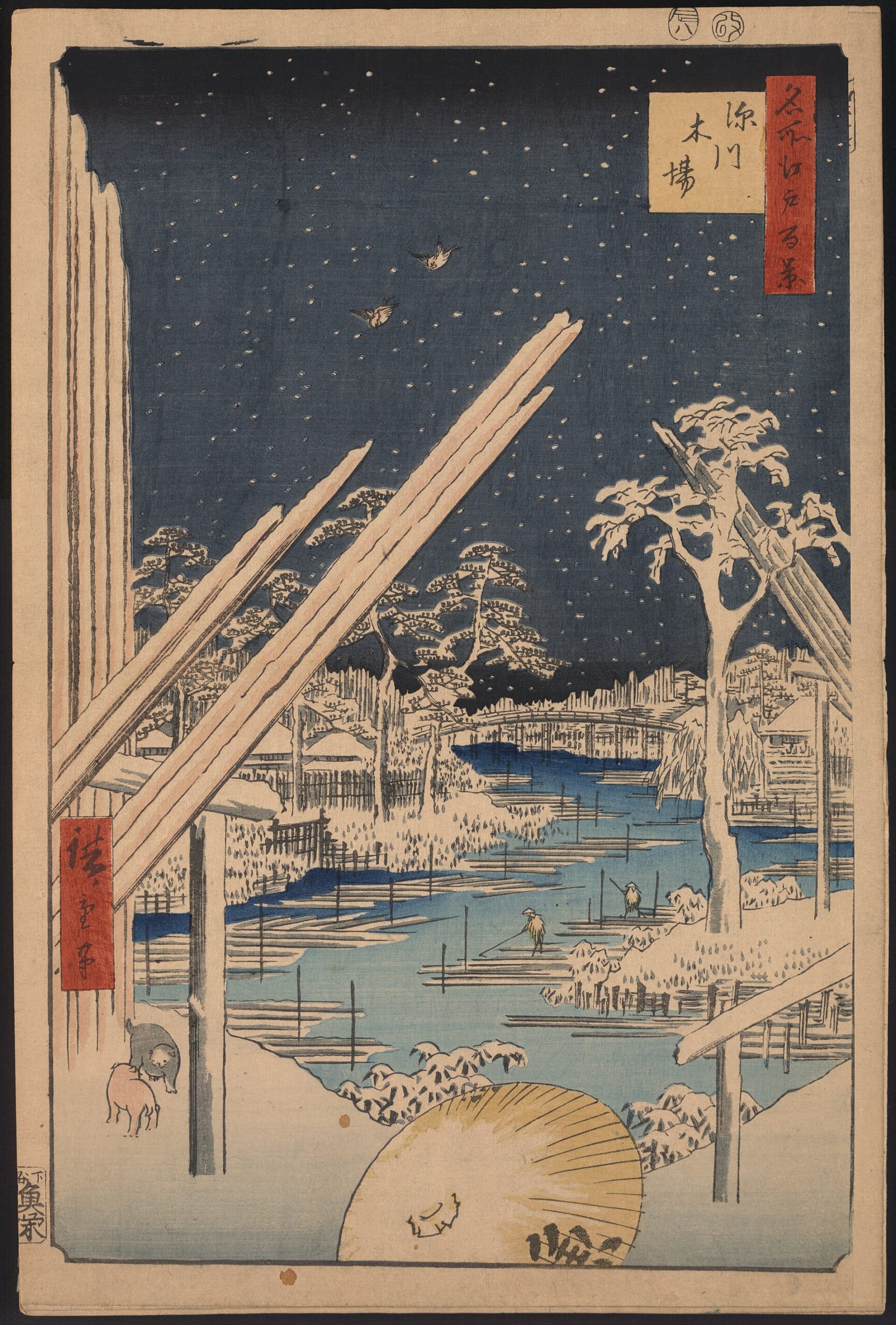
The timber economy included far more than storage. Merchants arranged finance and sales, laborers handled rafts, and craftsmen processed wood for construction. The balancing skills remembered today in kaku-nori performances grew from dangerous work on floating timber.
Warehouses, Wharves and Merchant Wealth
Fukagawa’s logistics economy extended beyond timber. Rice, oil, fertilizer and other commodities moved through wharves and warehouses near the Sumida River and internal canals. Saga-cho and nearby districts became part of a broad storage and distribution system linked to central Edo.
Merchant wealth funded residences and gardens. The area around modern Kiyosumi Gardens passed through several elite and commercial owners before Mitsubishi founder Iwasaki Yataro developed it as a garden for guests and employees in the Meiji period.
Matsuo Basho in a Working Waterfront
The poet Matsuo Basho lived in the Fukagawa area during the 1680s at a hut known as Basho-an. The location offered some distance from central Edo while remaining connected through boats, bridges and riverside roads.
Fukagawa should not be imagined as a completely rural retreat. Basho lived within a changing waterside district of labor, trade and new urban development. Local markers preserve his association, although the riverbank and street pattern have changed too much to reconstruct every detail with certainty.
Kiyosumi Gardens: Commerce Becomes Landscape
Kiyosumi Gardens represents the transformation of merchant and industrial wealth into an elite landscape. In the Meiji period, the Iwasaki family developed the grounds as a strolling garden with a central pond, carefully placed stones and reception spaces.
The Great Kanto Earthquake destroyed the Western-style residence but the garden served as a refuge. Part of the estate was later donated to Tokyo and opened as a public park in 1932. Its pond, once connected to tidal water from the Sumida system, now uses rainwater.
Industry and the Hybrid Modern Waterfront
During the Meiji and Taisho periods, factories joined the older warehouses and wholesalers. Waterways still moved heavy cargo while modern roads and railways expanded. Wooden houses, concrete warehouses, temple streets and industrial plants occupied neighboring blocks.
This hybrid landscape survived into the postwar period. Barges remained useful, but trucks and larger port facilities gradually changed the economics of transport. Some canals were narrowed or filled, while others were enclosed by stronger flood-control structures.
The Great Kanto Earthquake and Reconstruction
The Great Kanto Earthquake of 1923 devastated Fukagawa. Soft lowland ground, dense wooden construction and fire made the eastern city especially vulnerable. Canals could provide water and routes under ordinary conditions, but smoke, debris, broken bridges and crowds turned them into obstacles during the disaster.
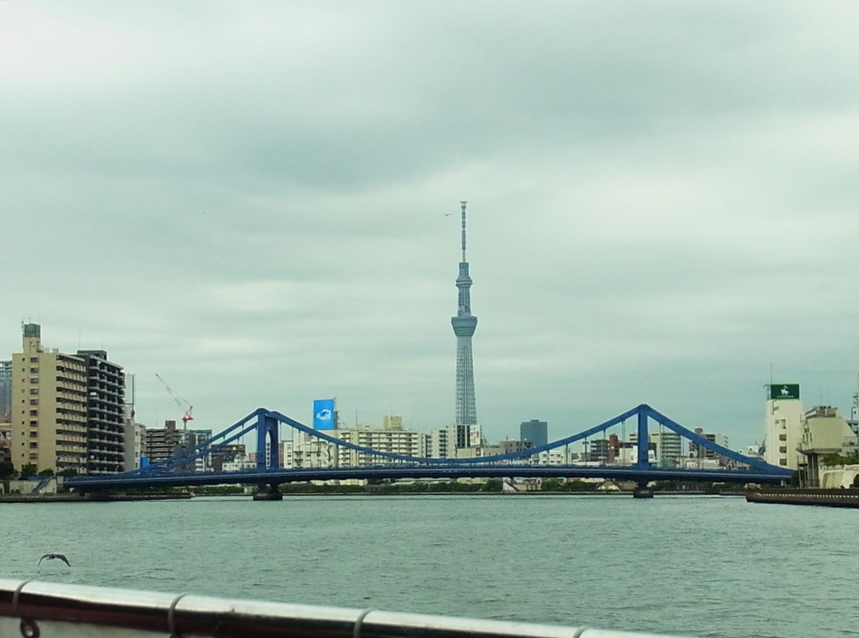
Reconstruction changed the city at district scale. Land readjustment altered plots, wider roads improved access and new bridges linked the eastern lowlands more directly with central Tokyo. Kiyosu Bridge, completed in 1928, became one of the clearest monuments of this reconstruction program.
War Damage and Postwar Recovery
The air raids of 1945 destroyed large parts of Koto City. Homes, temples, workshops, factories and warehouses burned. The devastation was caused by war rather than natural disaster, and recovery took place amid shortages, displacement and damaged infrastructure.
Postwar Fukagawa rebuilt unevenly. Small homes and workshops returned beside surviving industrial sites. Concrete construction expanded, roads improved and flood-control works strengthened. Institutional continuity often survived more clearly than architecture: temples, festivals, businesses and place names returned even where their buildings were new.
Why the Timber Trade Moved to Shinkiba
By the high-growth era, old Kiba could no longer handle modern timber logistics efficiently. Land was limited, roads crowded and canal storage conflicted with dense urban development. Larger reclaimed sites farther south offered space for trucks, processing yards and modern port access.
The timber industry gradually moved to Shinkiba—“new timber place.” The relocation released old industrial land for parks, housing and public facilities. Kiba Park is therefore not an intact lumber yard preserved as scenery. It is a major reuse of land whose former industry moved elsewhere.
Kiyosumi-shirakawa and Adaptive Reuse
Kiyosumi-shirakawa is now associated with coffee roasters, galleries and design businesses. The change reflects access to central Tokyo, relatively large ground-floor spaces, former warehouses and workshops, and the district’s canals and garden landscape.
The modern café economy is not a direct continuation of Edo commerce. Its connection to the past is spatial. Earlier logistics and industry produced buildings and parcels that later became useful to new businesses. Some structures were genuinely adapted; others were replaced by new buildings designed to fit the industrial image.
What to Look For Today
- Tomioka Hachiman Shrine: an active center of festival and neighborhood networks.
- Fukagawa Fudo-do: a pilgrimage institution whose approach still supports commerce.
- Monzen-nakacho: the modern transport and restaurant district built around religious foot traffic.
- Kiba Park: reclaimed public space on land associated with the relocated timber industry.
- Kiyosumi Gardens: a merchant and industrial-era estate transformed into a public garden.
- Canals and bridge names: traces of the water-based transport network.
- Kiyosu Bridge: a monument of post-earthquake reconstruction.
- Former warehouses and workshops: evidence of the industrial landscape behind Kiyosumi-shirakawa’s modern image.
Timeline
| Keicho era, 1596–1615 | Early development associated with Fukagawa Hachiroemon establishes Fukagawa Village. |
| 1620s | Tomioka Hachiman Shrine is founded on developing reclaimed land. |
| 1657 | The Great Fire of Meireki accelerates Edo’s expansion eastward. |
| 1680s | Matsuo Basho lives in Fukagawa. |
| 1701 | The main timber yards move to the area that becomes Kiba. |
| 1703 | Naritasan devotional exhibitions begin in Fukagawa. |
| 1878 | Fukagawa becomes one of Tokyo’s fifteen wards. |
| 1923 | The Great Kanto Earthquake devastates the district. |
| 1928 | Kiyosu Bridge is completed. |
| 1945 | Air raids destroy much of the built environment. |
| Late twentieth century | Timber functions move to Shinkiba and old industrial land is redeveloped. |
| Twenty-first century | Housing, adaptive reuse, culture and café businesses add new layers. |
Frequently Asked Questions
Was all of Fukagawa reclaimed at one time?
No. Different areas were drained, embanked and filled in separate projects over several centuries.
Why were there so many canals?
They drained reclaimed land, moved cargo, connected rivers and storage yards, and organized the street plan.
Why did Kiba become a timber district?
Waterways allowed bulky logs to be floated, stored and distributed close to Edo’s enormous construction market.
Is Kiba Park a preserved timber yard?
No. It is a later public reuse of land associated with the old timber district after the industry moved to Shinkiba.
Are Kiyosumi-shirakawa’s cafés inside old warehouses?
Some businesses adapt former industrial buildings, but many occupy newer or substantially rebuilt structures. Each building must be checked individually.
Related Neighborhood Histories
Compare Fukagawa with Ryogoku, where disaster reconstruction created a different eastern entertainment district, and browse the full Tokyo Neighborhood Histories directory.
Sources and Further Reading
- Koto City: The Origins and Development of Koto
- Tomioka Hachiman Shrine official website
- Naritasan Fukagawa Fudo-do official website
- Fukagawa Tourism Association: Fukagawa Festival
- Tokyo Metropolitan Park Association: Kiyosumi Gardens
- Tokyo Metropolitan Government: Kiyosu Bridge
- Tokyo Metropolitan Library: Edo and Tokyo resources
Conclusion: A Neighborhood Built from Water
Fukagawa’s history begins with the difficulty of making low delta land usable. Reclamation created ground; canals made the ground productive; temples and shrines brought crowds; timber and warehouses created wealth; disaster forced reconstruction; and industrial change released land for parks, housing and cultural reuse.
The district’s modern appeal is therefore inseparable from its engineered past. Coffee shops, gardens, festival streets and waterfront walks occupy a landscape first built for drainage, boats and heavy cargo.