Tokyo’s greatest museum district exists because a civil war destroyed one of the city’s most powerful Buddhist temple complexes. In 1868, imperial troops attacked the last defenders of the Tokugawa shogunate on Ueno Hill. Kan’ei-ji burned, the old political order collapsed, and land once reserved for shogunal religion became available for a radically different project: educating the citizens of a modern nation.
That is why a zoo, art schools, concert halls and national museums stand beside surviving temple gates, a Tokugawa shrine and graves from the Battle of Ueno. Below the hill, a railway terminal brought generations of migrants from northern Japan; after 1945, scarcity turned the tracks toward Okachimachi into the market now known as Ameyoko.
Modern Ueno exists because Tokyo repeatedly converted the same landscape into a new kind of gateway: first to sacred authority, then to imperial victory and public knowledge, then to the railways of northern Japan, and finally to postwar survival and mass tourism. Few places in Tokyo reveal so clearly how defeated institutions can become the foundations of a new city.
Quick Facts
Japanese name: 上野
Municipality: Taito City, Tokyo
Main access: Ueno, Keisei-Ueno and Ueno-hirokoji stations
Historical core: Ueno plateau, the former Kan’ei-ji precinct, Ueno Park, Shinobazu Pond and the station district
Main historical layers: Tokugawa temple city, pilgrimage and leisure, Battle of Ueno, early public park, industrial exhibitions, museums and zoo, railway migration, earthquake and war damage, postwar market commerce
Why Ueno Became a Temple, Park, Museum and Railway District
Ueno’s identities were created in succession, but each new system reused the spatial advantages and symbolic power of the one before it. The plateau was prominent and defensible. Kan’ei-ji turned that high ground into a sacred and political landscape. The destruction of much of the complex in 1868 made large tracts available to the new government. Park designation preserved open land while allowing the state to redefine its purpose. Exhibitions and museums then made the park a stage for knowledge, industry and national culture. The station at the foot of the plateau brought enormous flows of passengers, workers and goods.
The result is a district divided vertically and functionally. On the hill are institutions associated with culture, memory and public education. Around the station and lowland edges are transport, lodging, wholesale and retail commerce. Yet the two zones have always depended on one another: crowds generated by worship, exhibitions, museums, trains and markets repeatedly overlapped.
The Geography of the Ueno Plateau and Lowlands
Ueno sits on the eastern edge of the Musashino uplands, where higher ground falls toward the lowlands of the Sumida River basin. The contrast remains visible around Shinobazu Pond and the slopes leading between the park and the streets below. Before modern drainage and construction, wetlands and waterways made the low ground environmentally different from the dry plateau.
This topography influenced movement and land use. Elevated ground offered long views and relative protection from flooding, while the lowlands connected with commercial and transport networks extending through eastern Edo. The name “Shinobugaoka,” or Shinobu Hill, appears in older references to the ridge. Later, the combination of a spacious plateau and accessible lowland approaches helped Ueno function first as a major religious precinct and then as a public destination.
Before Kan’ei-ji
The Ueno hill was not empty before the seventeenth century. Medieval religious sites, routes and settlements existed in the wider area, while Shinobazu Pond formed part of a lowland waterscape. The evidence does not support a simple story in which the shogunate created civilization on unused land. What changed under Tokugawa rule was the scale, patronage and political meaning of development.
After Tokugawa Ieyasu established his government in Edo, the northeastern side of the castle acquired strategic and cosmological importance. In traditional directional belief, the northeast was the kimon, an unlucky “demon gate.” Building a major temple on the Ueno ridge gave the shogunate a powerful religious institution in that direction while also monumentalizing the edge of the growing city.
Kan’ei-ji and the Tokugawa Political Landscape
Kan’ei-ji was founded in 1625 under the influence of the Tendai monk Tenkai and with Tokugawa support. Its mountain name, Tōeizan, deliberately evoked Enryaku-ji on Mount Hiei northeast of Kyoto. The parallel placed Edo within an older sacred geography while expressing the shogunate’s ambition to build a durable political center.
The temple began as an institution praying for the stability of the shogunate and the peace of the realm. Over time it also became closely associated with the Tokugawa family. Six shoguns were buried in its cemetery, and imperial princes served as abbots in the Rinnoji-no-miya lineage. Kan’ei-ji was therefore not merely a neighborhood temple. It connected Buddhist authority, imperial status and shogunal power.
The complex expanded across much of present-day Ueno Park. Numerous subtemples, gates, halls, pagodas and residences created a vast sacred precinct. Surviving landmarks such as Kiyomizu Kannon-dō, the five-storied pagoda and Ueno Tōshōgū are fragments of that much larger order.
A Temple City on the Edge of Edo
Kan’ei-ji reshaped not only the hill but the surrounding urban economy. Clergy, retainers, craftsmen, servants and suppliers supported the institution. Approaches to the precinct attracted shops, teahouses and lodging. Pilgrims and sightseers moved between temple buildings, Shinobazu Pond and neighboring districts.
Ueno was thus a temple city rather than a single enclosed sanctuary. Its spaces combined ritual, administration, residence and commerce. The shogunate’s patronage provided prestige, but popular use gave the area daily life. Cherry blossoms, views and the pond made the hill a destination for seasonal leisure as well as worship.
Pilgrimage, Leisure and Popular Entertainment
Religious travel in Edo was rarely separated from recreation. Visitors prayed, ate, bought goods, watched performances and enjoyed the landscape. Kan’ei-ji’s branch halls consciously referenced famous sacred places around Kyoto. Kiyomizu Kannon-dō recalled Kiyomizu-dera, while Bentendō on Shinobazu Pond evoked the island sanctuary of Chikubushima.
These references allowed residents to experience a compressed sacred geography without leaving Edo. They also turned the precinct into a place of visual pleasure. Vendors, spectacles and temporary entertainments gathered where crowds already existed. This pattern anticipated Ueno’s later role as an exhibition and museum district: the hill repeatedly became a place where large publics encountered organized displays.
The Shogitai and the Battle of Ueno
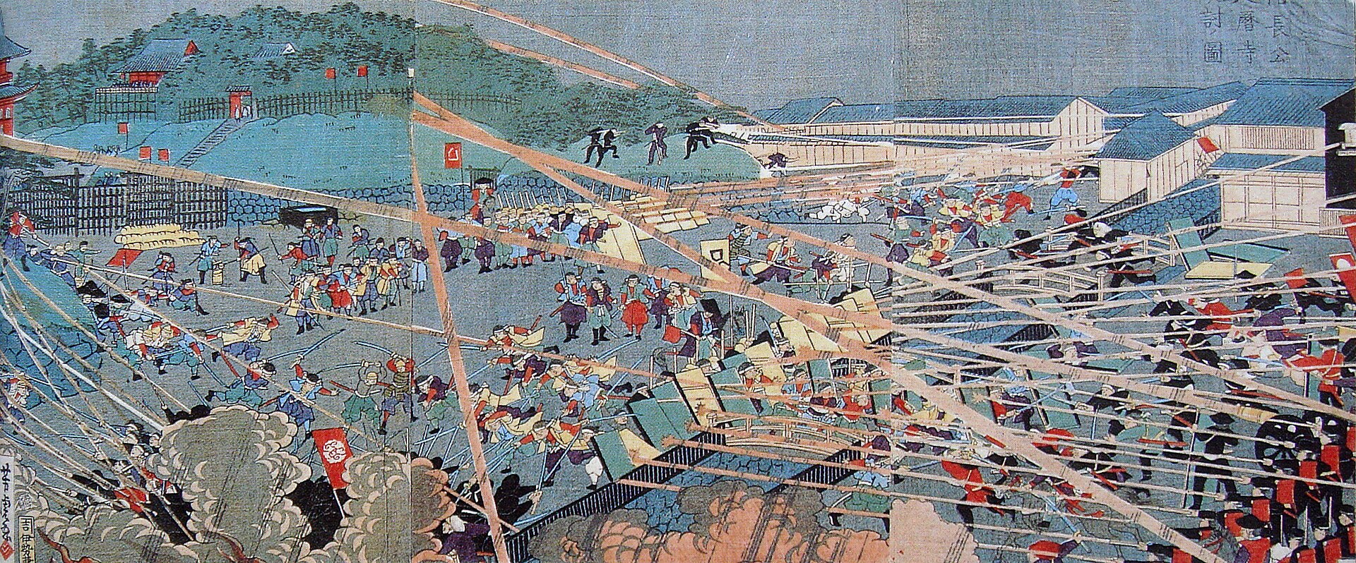
In 1868, as the Tokugawa regime collapsed, former retainers organized the Shogitai and gathered at Ueno. The location was politically charged. Yoshinobu Tokugawa had withdrawn to Kan’ei-ji before leaving Edo, and the temple remained associated with the old order even after the city was surrendered.
On 4 July 1868 by the Gregorian calendar, imperial forces attacked Shogitai positions on and around the hill. The fighting was brief but destructive. Government troops used superior organization and artillery, including an attack from the direction of Hongō. Fires consumed much of the Kan’ei-ji complex, and the Shogitai were defeated by the end of the day.
The Destruction of the Temple-City Order
The battle did more than destroy buildings. It broke the institutional system that had organized Ueno for more than two centuries. The new government confiscated much of the former temple land. Policies separating Buddhism and Shinto, together with the loss of Tokugawa patronage, further weakened Kan’ei-ji and its subtemples.
Kan’ei-ji survived, but on a drastically reduced site north of the park. The old precinct was fragmented among religious survivors, cemeteries, state land and new public institutions. Modern Ueno was built from this dispossession. Its museums and park should therefore be understood not simply as additions to a temple landscape but as products of a political transfer of land after civil war.
Why the Meiji Government Created Ueno Park
In 1873, the government designated Ueno as one of Japan’s earliest public parks. The decision followed debate over how to use the former temple grounds. A proposal for medical facilities was opposed by the Dutch physician Anthonius Bauduin, who argued that the hill should be preserved as open public space.
The park designation was modern, but it also drew on older habits. Ueno had long been a place for worship, cherry viewing and leisure. The Meiji state retained the public attraction of the hill while changing its legal status and ideological purpose. In 1876, Ueno Park formally opened under new administration.
The park became a tool of governance. It provided recreation, protected open land and offered a setting for institutions that could educate citizens and represent the modern nation. Its lawns and avenues did not erase the temple past; they reorganized its space.
Industrial Exhibitions and the Display of Modern Japan
Ueno hosted the first National Industrial Exhibition in 1877 and later exhibitions in 1881 and 1890. These events presented machinery, manufactured goods, agricultural products, art and technology to enormous audiences. They were meant to encourage industry, compare regional production and demonstrate the direction of national modernization.
The exhibitions transformed the park into a temporary city of pavilions, crowds and spectacle. Their logic resembled the older festival and temple economy in one respect: they concentrated people around things to be seen. Yet the authority behind the display had changed. Buddhist ritual and shogunal prestige gave way to state-sponsored industry, classification and progress.
The Rise of Museums, Art and Science Institutions
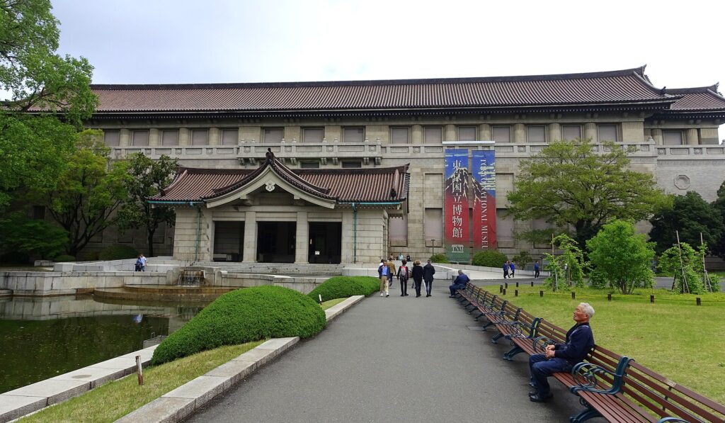
The exhibition culture of early Meiji Ueno helped establish the district as a permanent center for collections and public knowledge. The institution that became the Tokyo National Museum moved to Ueno in 1882. Over time, art, archaeology and cultural properties were organized within a national museum framework.
Other institutions followed or developed nearby. The National Museum of Nature and Science traces its institutional history to the nineteenth century and opened facilities in Ueno. The Tokyo School of Fine Arts and Tokyo Music School, predecessors of today’s Tokyo University of the Arts, made the area a center for professional education. The Tokyo Metropolitan Art Museum opened in 1926, and the National Museum of Western Art opened in 1959.
Together these institutions turned the former temple precinct into a cultural district. Their collections differ, but their coexistence makes Ueno unusual: national history, natural science, Western art, contemporary exhibitions, performance and art education occupy adjoining sites.
Ueno Zoo and Public Education
Ueno Zoo opened in 1882 as part of the museum complex and is generally recognized as Japan’s oldest modern zoo. Like museums, zoos were institutions of classification and public instruction as well as entertainment. Animals were arranged for observation within a framework that reflected contemporary ideas about science, empire and civilization.
The zoo’s history also includes difficult episodes. Animals died during wartime shortages, and dangerous animals were killed under military orders in 1943. Postwar rebuilding later made the zoo a symbol of recovery and international exchange. Its continuing popularity shows how education, leisure and mass spectatorship remain intertwined in Ueno.
Ueno Station and the Gateway to Northeastern Japan
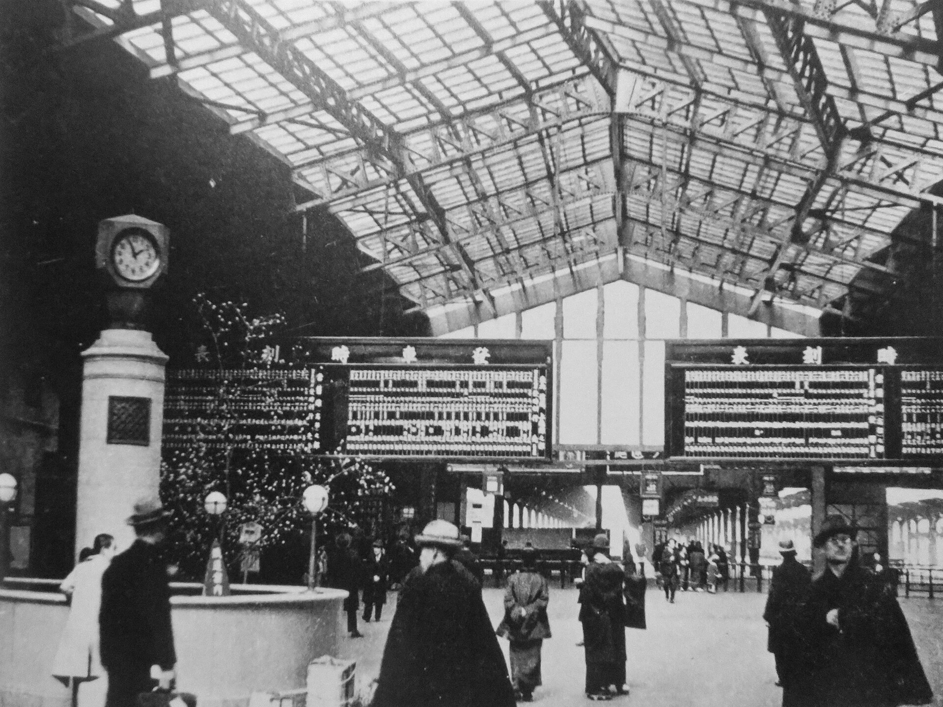
Ueno Station opened in 1883 as the southern terminal of the railway to Kumagaya. The line extended northward, and Ueno became Tokyo’s principal gateway to northern Kanto and the Tōhoku region. Unlike stations serving western or southern routes, Ueno acquired a strong cultural association with people arriving from the north.
The station stood at the foot of the plateau rather than inside the park. This location created a powerful transition: passengers emerged from a transport and commercial zone directly beside one of the capital’s largest concentrations of public institutions. Railways expanded the audience for museums, exhibitions, temples and cherry blossoms, while the park gave the terminal district a destination beyond travel itself.
Migration, Commerce and the Railway City
Railway traffic changed the social geography around Ueno. Migrants arriving for work, students, soldiers, traders and seasonal travelers created demand for inns, restaurants, employment brokers, wholesalers and inexpensive retail. The station became a place of departure and arrival, but also a labor market and social threshold.
These flows helped strengthen commercial streets toward Okachimachi and the lowlands. Goods from northern and eastern Japan moved through the district, while Tokyo-made products traveled outward. Ueno’s identity as a railway gateway was therefore economic and demographic, not only symbolic.
The Great Kanto Earthquake
The Great Kanto Earthquake struck on 1 September 1923. Ueno Park became an important refuge because its open grounds offered space away from the fires spreading through densely built districts. Museums and other structures suffered damage, while the surrounding city faced destruction, displacement and emergency relief.
The disaster reinforced the value of large public spaces in a crowded metropolis. Reconstruction modernized roads, buildings and infrastructure around Ueno, but it also accelerated changes already driven by rail traffic and mass consumption. The present station building opened in 1932, replacing the earlier structure and giving the gateway a monumental urban facade.
War Damage and Postwar Reconstruction
Air raids in 1945 damaged Ueno and the surrounding districts. The park again served as open space in a city under extreme pressure. After surrender, the station area filled with demobilized soldiers, repatriates, displaced families and people searching for food and work.
Reconstruction occurred unevenly. Major cultural institutions were repaired or rebuilt, while informal commerce occupied streets and spaces around the railway. This contrast between official reconstruction on the hill and improvised survival below it is central to postwar Ueno.
Ameyoko and the Postwar Market
Ameyoko developed along and beneath the railway between Ueno and Okachimachi. Its name is commonly explained through two overlapping associations: ame as candy, sold when sugar was scarce, and Ame as an abbreviation for America, reflecting the circulation of imported or occupation-related goods. The exact balance changed over time, and the name should not be reduced to a single origin story.
The market grew from the shortages and regulatory instability of the early postwar years. Informal and black-market trade supplied food, clothing and daily necessities that official distribution could not reliably provide. As the economy recovered, businesses became more regularized and diversified. Today the district sells seafood, dried goods, clothing, cosmetics and international foods, but its density and bargaining culture still recall its postwar formation.
How Ueno’s Multiple Identities Coexist Today
Modern Ueno is not a neat succession in which one identity replaced another. Kan’ei-ji remains active, and surviving temple buildings continue to structure the park. Museums occupy land once shaped by the temple complex. The zoo and cultural institutions attract family and educational visits. The station continues to connect Tokyo with eastern and northern Japan, even though through services and Shinkansen extensions have reduced its role as an absolute terminal. Ameyoko remains a major commercial destination.
These functions coexist because they draw different crowds at different times while sharing the same transport node. A museum visitor, commuter, worshipper, market shopper and newly arrived traveler may cross the same streets without experiencing the same Ueno. The district’s character lies in that overlap.
What Historical Traces Can Be Seen Today
- Kiyomizu Kannon-dō: a surviving part of the Kan’ei-ji landscape, positioned to evoke Kyoto’s Kiyomizu-dera.
- Shinobazu Pond and Bentendō: evidence of the lowland waterscape and the temple’s sacred geography.
- Ueno Tōshōgū and the five-storied pagoda: rare survivors from the pre-1868 precinct.
- The Kuromon and Shogitai memorial area: reminders of the Battle of Ueno.
- Kan’ei-ji cemetery and mausoleum gates: traces of the Tokugawa funerary complex north of the park.
- Tokyo National Museum and other cultural institutions: the Meiji and later reuse of former temple land.
- Ueno Station: the railway gateway that redirected movement through the district from 1883 onward.
- Ameyoko: a postwar commercial landscape shaped by scarcity, informal trade and railway foot traffic.
Opening hours, access rules and construction conditions change. Check official information before visiting. These places are presented as historical evidence rather than as a fixed walking route.
Timeline
| 1625 | Kan’ei-ji is founded under Tenkai with Tokugawa support. |
| 17th–19th centuries | The temple complex expands and Ueno develops as a center of worship, leisure and Tokugawa commemoration. |
| 4 July 1868 | Imperial forces defeat the Shogitai in the Battle of Ueno; much of Kan’ei-ji burns. |
| 1873 | Ueno is designated as one of Japan’s earliest public parks. |
| 1877 | The first National Industrial Exhibition opens in Ueno. |
| 1882 | Major museum and zoo facilities open in Ueno. |
| 1883 | Ueno Station opens as the terminal for the line to Kumagaya. |
| 1923 | The Great Kanto Earthquake damages the district; the park serves as refuge. |
| 1932 | The present Ueno Station building opens. |
| 1945 | Air raids and defeat create severe destruction and displacement. |
| Late 1940s onward | Ameyoko grows from postwar market activity into a major retail district. |
| 1959 | The National Museum of Western Art opens. |
| Today | Ueno combines temple heritage, parkland, museums, rail transport and dense commerce. |
FAQ
Was Ueno Park originally part of Kan’ei-ji?
Much of today’s park formed part of the far larger Kan’ei-ji precinct. The temple complex was heavily damaged in 1868, and the Meiji government later took control of most of the land and designated it as a public park.
Why are so many museums located in Ueno?
The former temple grounds provided a large state-controlled site close to central Tokyo. Industrial exhibitions established Ueno as a place for organized public display, and permanent museums, schools and cultural institutions followed.
Why is Ueno associated with northeastern Japan?
From 1883, Ueno served as the main Tokyo terminal for railways running north. Generations of migrants, students, workers and travelers from northern Kanto and Tōhoku arrived through the station, giving it a lasting cultural identity as Tokyo’s northern gateway.
Is Ameyoko a wartime or postwar market?
Its recognizable development belongs mainly to the immediate postwar period, when shortages and informal trade concentrated around the railway. It later became a regular commercial district while retaining elements of market-style retail.
Related Stories
For another Taito City district shaped by religion, crowds and entertainment, read The History of Asakusa: From Temple Town to Entertainment Capital. Explore the wider collection at Tokyo Neighborhood Histories.
Related Self-Guided Walks
No related English self-guided walk has been confirmed for Ueno as of July 2026. See the Self-Guided Walks collection for currently published routes.
Explore Tokyo’s History Together
TimeWalk Japan brings people together to explore how Tokyo’s streets, stations, rivers and neighborhoods were shaped. Visit the site’s meetup information to find current opportunities to walk and learn with others.
Sources and Further Reading
Kan’ei-ji official history; Taito City cultural history of Kan’ei-ji; Taito City account of the Battle of Ueno; Taito City guide to Ueno Park; Tokyo Metropolitan Government: Ueno Park; Tokyo National Museum institutional history; National Museum of Nature and Science institutional history; Tokyo Metropolitan Art Museum history; Ueno Zoo official history; National Diet Library Digital Collections; Tokyo Metropolitan Archives; JR East historical materials.