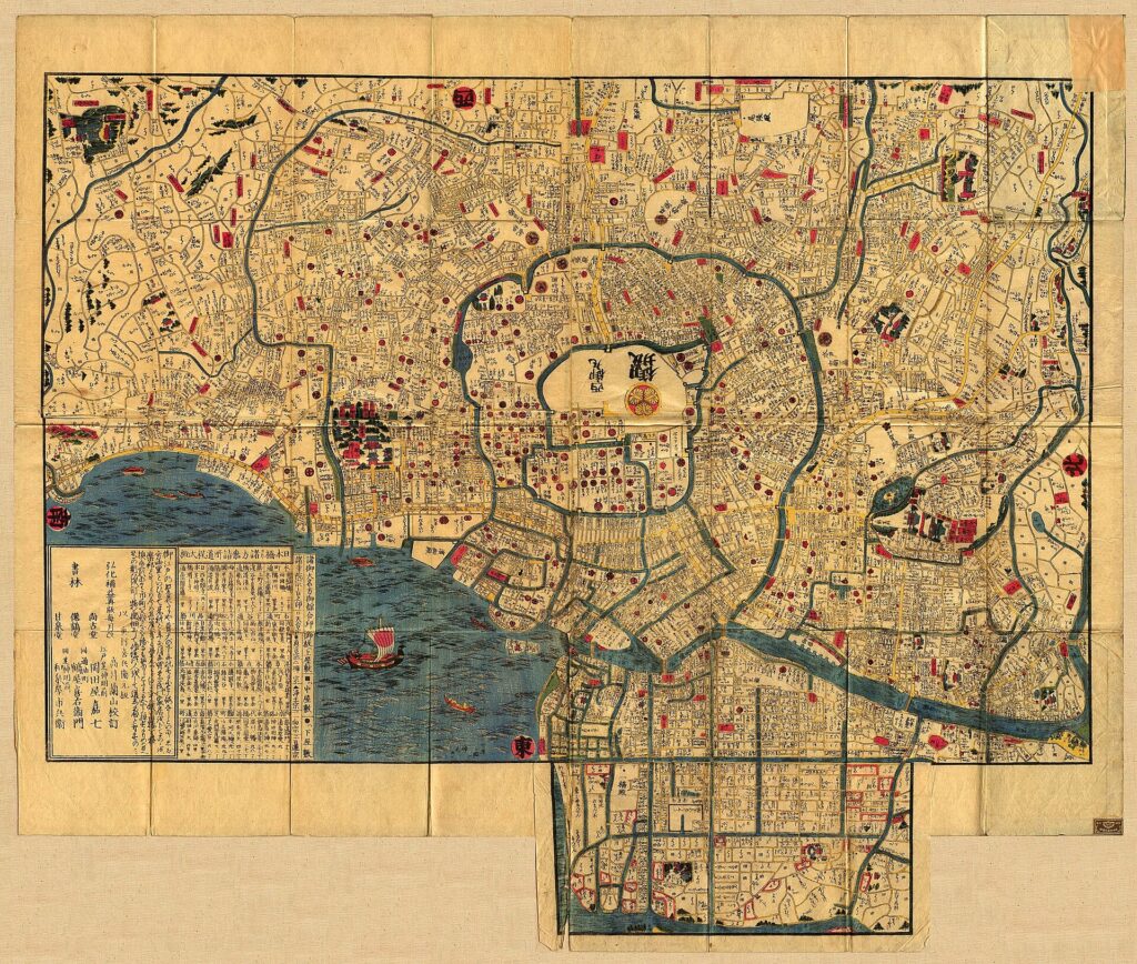
You are standing beside Nihonbashi Bridge with a smartphone map open in one hand and a mid-nineteenth-century Edo map on the screen in the other. The modern map is familiar: north is at the top, roads are measured consistently, and your position appears as a blue dot. The old map seems to follow different rules. Labels face several directions. Roads widen and narrow unpredictably. Waterways dominate the page. Large compounds carry the names of daimyo, while smaller town names crowd the commercial districts.
At first, it can feel unreadable. Then you stop trying to match every line. You find the bridge. You trace the river. You identify the castle and its moats. You notice how the dense merchant quarter differs from the broad samurai estates. Gradually, the old city begins to align with the modern one. The streetscape has changed, but the structure of Edo still influences Tokyo’s bridges, blocks, place names, slopes and waterways.
This guide shows you how to make that transition from looking at an old map to actually reading it. You will learn what Japanese ezu were made to do, how to read an Edo kiriezu step by step, where to find reliable maps online, how to compare them with modern Tokyo, and how to apply the method on a walk from Nihonbashi to Ote-mon Gate.
What You Will Learn
- How old Japanese maps differ from modern navigation maps.
- How to identify orientation, colors, names, land use and waterways.
- How Edo city maps, kiriezu, route maps, provincial maps, village maps and castle plans differ.
- How to compare a historical map with modern Tokyo without forcing every line to match.
- What to observe between Nihonbashi and the former Edo Castle.
What Is an “Old Japanese Map”?
English-language collections use several overlapping terms, including old Japanese maps, historical maps, early maps and pre-modern maps. In Japanese, many of these materials are described as ezu (絵図). The word does not refer only to a modern-style surveyed map. It can include visual records of cities, villages, castles, roads, provinces, fields, waterways, boundaries and land use.
An ezu was created for a purpose. Officials used maps for administration, land management and territorial control. Villages documented fields, irrigation and boundaries. Travelers consulted route maps. Publishers sold city maps to residents and visitors. Castle plans recorded gates, enclosures, defensive approaches and moats. Because purpose shaped design, two maps of the same place could look very different without either one being useless or “wrong.”
A modern navigation map tries to provide a standardized spatial framework that can support many tasks. A historical map was often more selective. A route map might compress the countryside but show post stations clearly. A city guide might enlarge famous sites and simplify less useful areas. A village map might record irrigation channels more carefully than roads. The right question is therefore not simply, “How accurate is this map?” but “What information was this map designed to communicate?”
This is why old maps are historical evidence as well as location tools. They show what their makers, commissioners, publishers and users considered important. A map can reveal social rank, commercial activity, political authority, transport, defense and land use even when it does not reproduce space according to modern surveying conventions.
Why Old Japanese Maps Do Not Behave Like Modern Maps
Modern readers usually expect north at the top, a consistent scale, uniform symbols and labels that remain upright. Many Japanese historical maps use a different information design.
Orientation follows the subject
North is not always at the top. A map may be oriented around a castle, a coastline, a route, a river system or the shape of the paper. Some city maps were designed to be rotated while reading. The direction of labels may change from one district to another, especially when names follow roads or estate boundaries.
Scale may not be consistent
Roads, compounds and landmarks may be enlarged for visibility. Distances may be compressed to fit a district onto one sheet. A prominent gate can occupy more space than its measured footprint would justify because it matters to movement and orientation. The map is prioritizing legibility, not necessarily geometric uniformity.
Important features are emphasized
A castle, temple precinct, ferry crossing, bridge or major estate might receive strong visual emphasis. Features irrelevant to the intended user may be simplified or omitted. Blank space therefore does not always mean undeveloped land.
When you look at a kiriezu, resist the impulse to treat irregularity as an error. Ask what the map makes easy to find. If waterways, gates, estate names and district labels dominate the sheet, those features were probably central to its intended use.
The Main Types of Old Japanese Maps
The categories below are enough for a beginner to recognize the main differences. Historical catalogues use more detailed terminology, and some documents overlap categories.
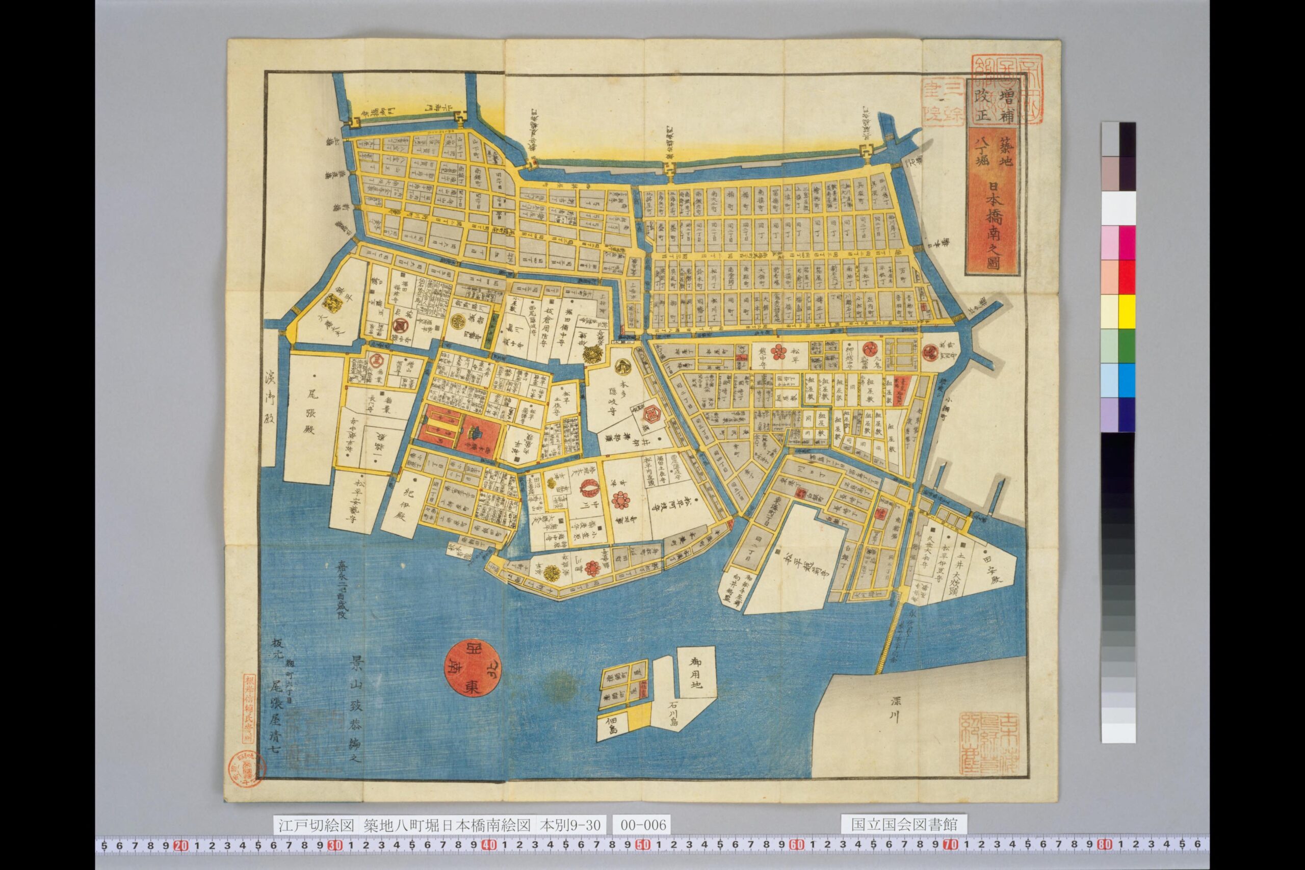
Look closely: Can you identify one waterway or bridge before reading any labels? Which area appears to contain the densest concentration of small place names?
Before reading the labels in this kiriezu, notice the contrast between dense small divisions and large named compounds. Follow the waterways around the district and observe how they organize movement and boundaries. Those relationships matter more at first than translating every place name.
Edo city maps, or Edo-zu
These maps show Edo as a whole or in broad overview. They were useful for understanding the relationship between the castle, bay, rivers, temple zones, samurai districts and merchant quarters. Modern readers can use them to understand the overall structure of the city, although they are often too dense for detailed walking.
Kiriezu
A kiriezu is a sectional map. Large cities were divided into smaller sheets that could show individual neighborhoods in greater detail. They were practical urban guides, especially useful for finding estates, temples, bridges, waterways and town names. Of the major historical map types, kiriezu are among the easiest to use for walking in central Tokyo.
Dōchūzu
Dōchūzu are route or itinerary maps. They emphasize highways, post stations, ferries, junctions and travel stages. Their surrounding geography may be compressed because the route itself is the main subject. They are valuable for reconstructing journeys but less useful for street-by-street urban navigation.
Kuniezu
Kuniezu depict historical provinces. They may show settlements, rivers, roads, coastlines, mountains and political relationships. They help modern readers understand territorial organization before the modern prefectural system.
Mura-ezu
Mura-ezu are village maps. They can record houses, fields, woodland, irrigation, roads, shrines and boundaries. They are especially useful for studying agriculture, water management and local disputes, but they are usually not designed for urban sightseeing.
Shiro-ezu and castle plans
Castle plans show gates, walls, baileys, moats and controlled approaches. They help readers understand defensive space and political access. In Tokyo, they are especially valuable around the Imperial Palace, where water, stone walls and gates still preserve part of the former Edo Castle framework.
How to Read an Edo Kiriezu, Step by Step
A kiriezu contains too much information to read all at once. The most reliable method is to move from features that are easy to identify toward features that require interpretation. The Tsukiji–Hatchobori–southern Nihonbashi map above is useful for reading dense merchant space and waterways. The Bancho map below is useful for reading estate names, text direction and large samurai parcels near Edo Castle.
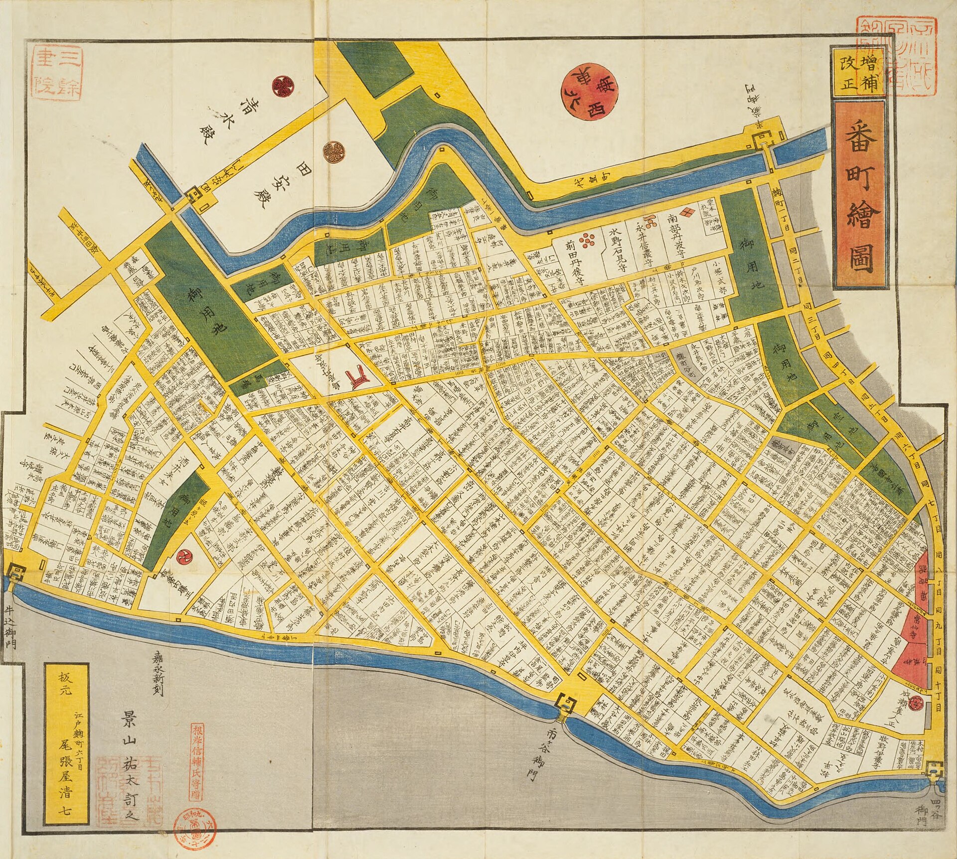
Try it yourself: Before translating anything, compare the size of the named estate blocks with the denser areas on the first kiriezu. Which labels appear to be aligned with roads, and which seem to sit inside compounds?
The Bancho map is a good reminder that an Edo map is not organized like a modern street plan. Large estate names dominate the sheet, labels run in different directions, and the castle-side geography gives the district its structure. Use the steps below while moving your eyes between the two images.
1. Start with one fixed landmark
Begin with a feature that has both a distinctive shape and a relatively stable location. On a citywide Edo map, the castle is often the strongest anchor. On a district map, a broad moat, a major river, a bridge or a long-established temple may be easier. On the Tsukiji–Hatchobori–southern Nihonbashi kiriezu, the waterways provide a more reliable first step than the fine street network. On the Bancho map, the district’s position relative to Edo Castle is more useful than any single small lane.
What to look for: a bridge, river bend, moat edge, castle boundary or major religious precinct that can also be found on another map. Why it matters: one fixed point turns a visually dense sheet into a spatial problem you can solve. Common beginner mistake: starting with a familiar-looking minor road and building the whole interpretation around a resemblance that may be accidental.
2. Work out the orientation
Do not assume that the top edge is north. First establish where the castle, rivers and adjoining districts lie. Then inspect the direction of the writing. In the Bancho image, estate names are not arranged to remain upright from a single viewing position. Some follow the available space inside a compound; others align with a road or boundary. That is a clue that the sheet was meant to be physically rotated or read from more than one side.
Once you have identified two or three landmarks, rotate the modern map on your phone until their relative positions match the old map. This is often easier than rotating the historical image because it lets you preserve the map’s original text orientation while comparing spatial relationships.
What to look for: river flow, the castle side of the district, label direction and the location of neighboring sheets. Why it matters: a correct orientation makes estate names, road direction and waterways easier to interpret together. Common beginner mistake: treating text direction as a compass rule by itself. Labels were also shaped by available space and readability.
3. Read colors carefully
Colors may indicate water, roads, temple land, townspeople’s districts, samurai estates or other categories, but they cannot be treated as a universal code. Different publishers used different conventions. Editions changed. Hand coloring could vary. Fading, restoration and digital reproduction may alter what you see today.
On the two kiriezu used here, begin by identifying repeated color fields and asking whether they correspond to water, dense town plots or large compounds. Then check the catalogue description or scholarly commentary before assigning a specific meaning. The safest interpretation is comparative: “this map distinguishes these spaces visually,” not “this color always means the same thing on every Edo map.”
What to look for: colors that repeat in the same type of space and stop at visible boundaries. Why it matters: color often reveals how the map classifies urban land. Common beginner mistake: memorizing one legend and applying it automatically to another publisher or decade.
4. Separate the city’s social spaces
Compare the fine-grained parts of the Tsukiji–Hatchobori–southern Nihonbashi map with the large blocks on the Bancho map. Dense clusters of small town names suggest townspeople’s districts, commercial streets and tightly subdivided property. Large compounds with prominent personal or house names point toward samurai estates. Temple and shrine lands form another kind of precinct, while castle space and water create controlled boundaries.
The difference in block size is not merely a graphic choice. It can reflect status, function and patterns of landholding. A large estate near the castle and a dense merchant district were both part of Edo, but they organized movement and daily life very differently.
What to look for: parcel size, number of labels, spacing between roads and proximity to the castle. Why it matters: these visual differences reveal the social geography of the city. Common beginner mistake: reading every named area as the same type of neighborhood.
5. Follow water before roads
Water is one of the most useful keys to Edo. Rivers, moats, canals and riverbanks supported transport, defense, drainage, boundaries and commerce. In the first kiriezu, waterways frame and cut through densely occupied districts. In the Bancho area, the relationship to castle-side moats helps explain orientation and political geography.
Modern roads have often been widened, straightened or rebuilt, while waterways may have been filled, covered or converted into roads. Yet their traces can survive in curving streets, low ground, bridge names, embankments, stonework and oddly shaped blocks. When an old map and a modern map refuse to align, stop tracing roads and trace the water system instead.
What to look for: river bends, bridge crossings, moat edges, former riverbank zones and places where roads follow a curve. Why it matters: water often preserves the deeper urban framework more clearly than roads. Common beginner mistake: treating waterways as background decoration rather than the structure that organized commerce, defense and movement.
6. Read names as dated evidence
Town names, estate names, temples, shrines and bridges reveal function and identity. On the Bancho map, the prominence of estate names is itself historical evidence: the map expected users to navigate through a district defined by samurai residences. But those names are also dated evidence. Estate ownership changed, neighborhoods were reorganized, and labels shifted after fire, rebuilding and political change.
What to look for: personal names, house names, town names and religious institutions. Why it matters: names help connect a sheet to a specific moment. Common beginner mistake: treating a named daimyo residence as if the same family occupied the site throughout the entire Edo period.
7. Notice what is missing
Blank areas can be misleading. A large compound may be shown as one labeled field with little internal detail. An area may be simplified because the map’s intended user did not need to know what happened inside it. Some features may have been omitted because of scale, paper size or the map’s practical purpose.
What to look for: abrupt changes in detail, large blank compounds and areas where roads or buildings stop being shown. Why it matters: omission tells you what the mapmaker considered unnecessary or inaccessible. Common beginner mistake: concluding that a blank area was empty, rural or undeveloped.
8. Compare more than one map
Use the two kiriezu here as a first comparison. One emphasizes dense merchant districts and waterways; the other emphasizes broad samurai parcels near the castle. Then compare maps from different dates, publishers or scales. A disagreement may reflect urban change, a different intended audience or a different graphic convention.
What to look for: changed names, altered water lines, different parcel divisions and different visual emphasis. Why it matters: comparison separates historical change from cartographic choice. Common beginner mistake: assuming that one surviving sheet provides the final answer.
A Map Is an Argument, Not Just a Picture
A historical map is not a neutral aerial photograph. Someone selected the area, symbols, labels, colors and level of detail. Those choices reflect the priorities of a maker, commissioner, publisher or user.
Ask not only what the map shows, but what it emphasizes and what it leaves out. Large estates can express political rank. Dense town names can show commercial intensity. Moats and controlled approaches can reveal defense and authority. Riverbanks and bridges can show logistics and movement.
At the same time, do not treat the map as sufficient proof by itself. Compare it with written documents, maps from another period, archaeological research and the present landscape. A map is strongest when used as one source among several.
Where to View Old Japanese Maps Online for Free
National Diet Library
Best for: searching a large national collection. What you can find: maps and ezu by place name, historical province, material type and subject through NDL Search and the NDL Digital Collections. Important limitation: viewing and reuse conditions vary by item, so check each catalogue record.
Explore the National Diet Library guide to pre-modern illustrated maps and old maps.
Tokyo Metropolitan Central Library: EDO TOKYO Digital Museum
Best for: connecting Edo-period images with places in present-day Tokyo. What you can find: maps, prints and historical materials linked to recognizable locations. Important limitation: it is a curated entry point rather than a complete catalogue of every surviving Edo map.
University of Zurich: Ad fontes
Best for: learning how to interpret maps as historical sources. What you can find: explanations of orientation, purpose, production, color and imagery from ancient through early modern maps. Important limitation: it is a source-reading tutorial, not a Tokyo route guide.
Study the Ad fontes Old Japanese Maps tutorial.
How to Compare an Old Map with Modern Tokyo
The following method can be repeated with any district map. The three images used in this article illustrate different stages: Media ID 4100 is useful for dense merchant space and waterways, Media ID 4123 for orientation and estate structure, and Media ID 4560 for the relationship between castle, moats and large compounds.
1. Confirm the map’s date, title and coverage
Read the catalogue record before comparing anything. Confirm that the map includes the district you want and note the date or estimated date. A map centered on southern Nihonbashi cannot be used to identify Bancho streets, and an 1840s estate label should not be projected backward or forward without evidence.
2. Choose three fixed points
Use three points rather than one. On the 4100 kiriezu, you might choose a major waterway, a bridge and a temple or district edge. On the 4123 Bancho map, use the castle side, a moat and a major road or gate relationship. On the 4560 castle plan, the castle, Ote-mon and surrounding moat system form a strong triangle.
3. Rotate the modern map
Turn off the assumption that modern north-up is the only useful view. Rotate the modern map until the three fixed points sit in the same relative positions as on the historical sheet. Do not worry if the labels are now sideways. The goal is spatial alignment, not visual comfort.
4. Trace rivers, bridges and moats before roads
Use the 4100 kiriezu to trace water through a dense district. Then use the 4560 castle plan to follow moat edges and controlled crossings. Roads are more likely to have been widened or rerouted; water boundaries, even when altered, often leave stronger traces in block shape, elevation and bridge names.
5. Compare blocks and intersections rather than every line
On the 4123 Bancho map, compare the scale of large estate blocks with present-day street spacing. On the 4100 map, compare the density of small divisions near waterways. Look for the relationship between intersections, district edges and water rather than forcing each historical lane onto a modern street.
6. Account for river works, earthquakes, war damage, railways and redevelopment
Tokyo was repeatedly transformed. River channels were engineered or filled. Railways cut through earlier patterns. The 1923 Great Kanto Earthquake led to reconstruction and road widening. Wartime destruction and postwar rebuilding changed neighborhoods again. More recent redevelopment created superblocks and underground infrastructure. A mismatch may reflect history, not a poor reading.
7. Verify with a second historical map or document
After forming a hypothesis, test it. Compare another kiriezu, a citywide Edo map, a castle plan, a library description or an official historical explanation. If the second source contradicts your reading, revise the hypothesis rather than forcing agreement.
8. Visit the site and test the hypothesis
Walk the area and look for physical evidence: a slope, stonework, a curving road, a bridge name, a surviving moat or a sudden change in block size. Treat the visit as a test, not proof. Modern construction, private property and inaccessible areas may limit what you can observe.
A Beginner’s Edo Map Walk: Nihonbashi to Edo Castle
The route from Nihonbashi through Tokiwabashi and Otemachi to Ote-mon is approximately 1.5–2 kilometers depending on the streets used. Allow about 60–90 minutes when stopping to compare maps and discuss the landscape. Check current access, construction and opening information before visiting.
1. Nihonbashi Bridge
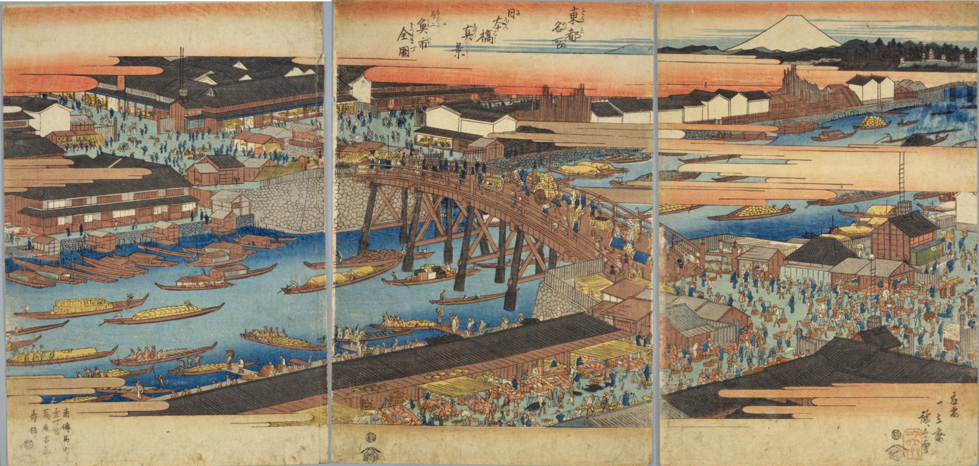
Look closely: Where is the river doing most of the spatial work in Hiroshige’s image? How does the bridge connect people, goods and streets rather than simply crossing water?
What the old map shows: a bridge crossing a major waterway within a dense commercial district. Nihonbashi also had symbolic importance as the starting point for measuring distances along major highways.
What you see today: the present stone bridge, the river and a heavily engineered modern cityscape. The river remains, but the setting is enclosed by modern roads, buildings and overhead infrastructure.
What changed: the timber bridge depicted by Hiroshige was replaced, the riverbanks were transformed, and the scale and materials of surrounding buildings changed completely. Waterborne commerce is no longer visible in the same form.
What to observe: the river’s direction, the bridge’s position, the roads approaching it and the way modern infrastructure encloses the water.
Why this point helps you read the map: bridge and river together form a fixed pair. Once they are aligned, the surrounding merchant district becomes easier to compare.
2. Merchant Edo around Nihonbashi
What the old map shows: dense small divisions, numerous town names and close relationships between streets, riverbanks, warehouses and commercial movement. The fine-grained pattern is very different from the broad samurai blocks seen closer to the castle.
What you see today: offices, department stores, banks, shops and modern roads. Commercial activity remains central, but goods now move through trucks, railways, underground networks and distribution systems rather than through the same riverbank logistics.
What changed: repeated fires, modern road building, earthquake reconstruction, wartime destruction and redevelopment altered the parcel pattern. Many former riverbank functions disappeared or moved, and warehouses were replaced by new building types.
What to observe: narrower blocks, surviving place names, routes leading toward the river, the density of commercial frontages and the contrast with the broader parcels toward Otemachi.
Why this point helps you read the map: it teaches you to recognize townspeople’s space through density. A cluster of small labels and tight divisions often indicates a very different urban function from a single large named estate.
3. Tokiwabashi and the lost waterscape
What the old map shows: the relationship between bridge, gate, outer moat and channels on the edge of Edo Castle. Movement was controlled by where water could be crossed and how the approach to the gate was organized.
What you see today: modern roads, railway infrastructure, river engineering, restored or surviving stonework in the wider Tokiwabashi area, and a landscape heavily reshaped by redevelopment.
What changed: parts of the outer-moat water network were altered, filled or absorbed into later transport infrastructure. The gate no longer functions as a controlled entrance, and the relationship between water and movement is less obvious at street level.
What to observe: bridge names, stonework, changes in ground level, roads that curve unexpectedly and the line where a former moat or channel may have shaped the city. Compare these clues with the historical map before following modern streets.
Why this point helps you read the map: Tokiwabashi makes the principle “follow water before roads” tangible. A modern road may be recent, but its alignment can still follow the edge of an older water system. The site teaches you to look for traces rather than complete survival.
4. Otemachi
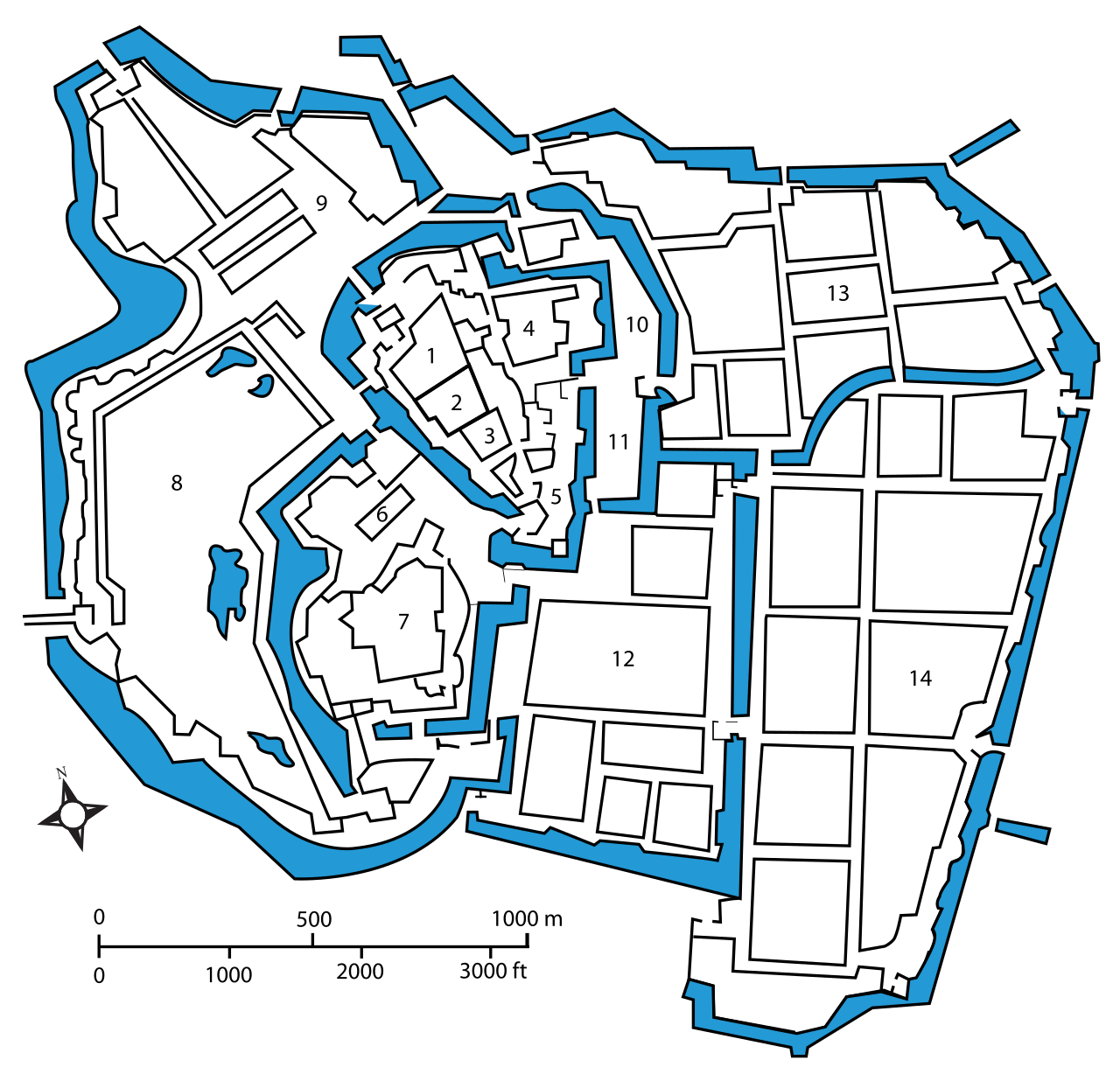
Try it yourself: Compare the scale of the castle and estate blocks with the merchant district shown earlier. Where does water define access, and where do large parcels reduce the density of intersections?
What the old map shows: large parcels near the castle, including daimyo residences and castle-related spaces. Individual owners must be tied to the date of a specific map because residence assignments changed.
What you see today: a major high-rise office district with large corporate blocks, broad roads, underground passages and a strong relationship to the Imperial Palace edge.
What changed: estate ownership disappeared with the end of the shogunate, and the district was repeatedly reorganized through modern administration, railways, earthquake reconstruction, war damage and redevelopment. The old parcels did not simply become today’s corporate blocks unchanged.
What to observe: the distance between intersections, the size of modern blocks, the remaining moat edge and the contrast between dense Nihonbashi streets and Otemachi’s larger-scale urban fabric.
Why this point helps you read the map: Otemachi teaches cautious comparison. Large blocks near the political center existed in both periods, but the reasons, ownership and functions changed. Similar scale does not prove direct continuity.
5. Ote-mon Gate
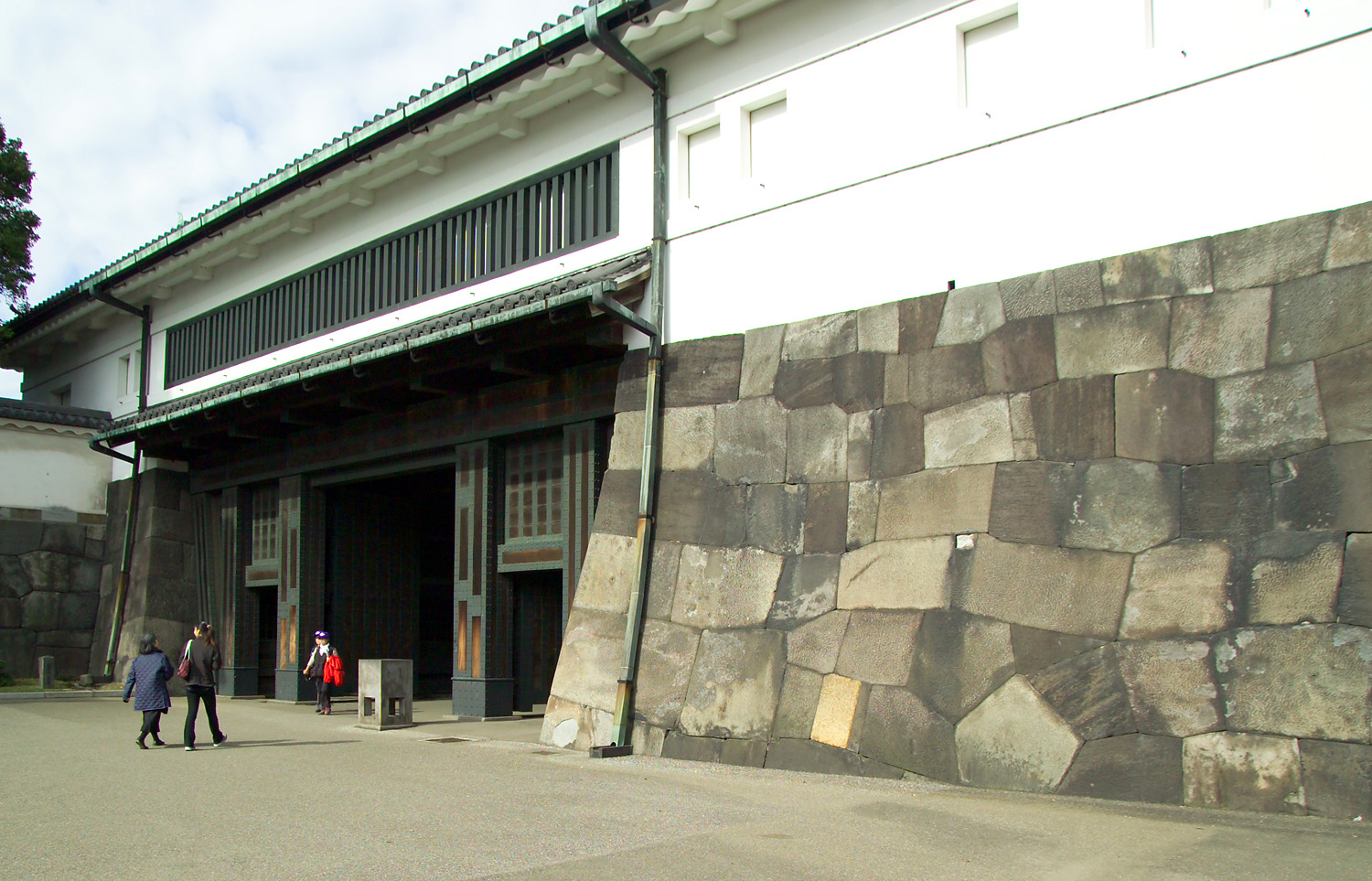
What the old map shows: a principal castle entrance integrated with moat, bridge, walls and a controlled approach.
What you see today: stone walls, water and reconstructed gate structures at the entrance to the East Gardens of the Imperial Palace.
What changed: the gate no longer controls access to the shogun’s political center, and parts of the castle complex were destroyed, rebuilt or repurposed. Yet the defensive relationship between approach, water and stone remains legible.
What to observe: the turn in the approach, the bridge, stone walls, water and the difference between a compact map symbol and a large three-dimensional defensive space.
Why this point helps you read the map: Ote-mon is where map symbol and surviving structure meet most clearly. It demonstrates that Edo’s urban framework did not disappear completely; parts remain in altered political, public and landscape functions.
Opening days, entry procedures and temporary closures can change. Check the Imperial Household Agency’s official information for the East Gardens before visiting.
Common Mistakes When Reading Old Japanese Maps
- Assuming north is always at the top.
- Treating all map colors as a universal code.
- Assuming blank space means empty land.
- Assuming estate owners and place names never changed.
- Forcing every historical line onto a modern road.
- Ignoring the date, edition, publisher and purpose.
- Using only one map to make a historical claim.
- Treating a decorative image as if it were a modern survey map.
- Looking only at roads and ignoring water.
What You Can See Once You Learn to Read the Map
Once you learn to read an old map, ordinary parts of Tokyo begin to carry new meaning. A curving road may follow a former water edge. A low area may recall a channel. A bridge name may preserve a vanished crossing. Large blocks can suggest the scale of former estates, while dense place names reveal commercial districts and townspeople’s neighborhoods.
You also begin to see the limits of the map. It is not a complete reconstruction of the past. It is selective, dated and shaped by purpose. Its value is that it helps you ask better questions of the modern city.
Between Nihonbashi and Ote-mon, the distance is short, but the urban transition is profound. The route moves from commercial Edo through a partly lost waterscape into the political and defensive space of the castle. That contrast is still visible when you know how to look.
Frequently Asked Questions
Are old Japanese maps accurate?
Many are accurate for the purpose they were designed to serve, but they may not use a consistent modern scale. A route map may accurately describe travel stages while compressing surrounding space. A city map may identify estates, temples and bridges effectively while simplifying minor streets. Accuracy should be judged in relation to date, purpose and map type.
Is north always at the top of an Edo map?
No. Orientation may follow a castle, river, coastline, route or the shape of the sheet. Use fixed landmarks, waterways and label direction to establish orientation.
What does kiriezu mean?
A kiriezu is a sectional map. A large city was divided into smaller district sheets that were easier to print, carry and consult. This makes kiriezu particularly useful for historical walking in central Tokyo.
What do the colors on Edo maps mean?
Colors may indicate water, roads, temple land, townspeople’s districts, samurai estates or other categories, but meanings vary by map, publisher, edition and date. Check the description or legend for the specific map rather than applying a universal code.
Can I use old Japanese maps for a walking tour today?
Yes. Choose a small area, identify several fixed landmarks, rotate the modern map to match the old one and trace water before roads. Use the historical map to guide observation, not to override modern access, safety rules or private-property boundaries.
Where can I view or download old Japanese maps for free?
The National Diet Library Digital Collections, Tokyo Metropolitan Central Library’s EDO TOKYO Digital Museum and university collections such as Ad fontes provide free access to many maps and learning resources. Download and reuse conditions vary, so check each item’s record.
Do I need to read Japanese to use an Edo map?
No. Begin with rivers, bridges, moats, the castle and recognizable place names. Basic Japanese and knowledge of historical names will help, but spatial relationships can be studied visually before every label is translated.
References and Further Reading
- National Diet Library, “Pre-Modern Illustrated Maps (Ezu) and Old Maps Held by the National Diet Library.” Useful for collection searching, map terminology and access conditions.
- Tokyo Metropolitan Central Library, “Great-Edo Map.” Useful for linking present-day Tokyo locations with Edo-period visual sources.
- Tokyo Metropolitan Central Library, “The Beginning of Edo as a Castle Town.” Useful for understanding the castle-centered development of Edo.
- Tokyo Metropolitan Central Library, “The Emergence of Greater Edo.” Useful for the city’s expansion and changing urban structure.
- University of Zurich, Ad fontes, “Old Japanese Maps.” Useful for orientation, purpose, production and source criticism.
- University of Zurich, Ad fontes, “Edo-period Maps.” Useful for understanding Edo-period map conventions and context.
Continue Exploring Tokyo’s History
Explore more stories about Japan’s cities and history, find self-guided historical walks in Tokyo, or join an English-friendly history event in Tokyo. You can also see upcoming TimeWalk Japan events on Meetup.