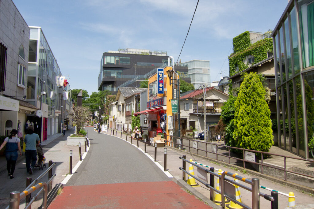
Tokyo’s most famous youth-fashion district grew beside a man-made sacred forest and on land that later became an American military suburb. Today Harajuku is associated with colorful street style, crowded boutiques and global pop culture. Yet the landscape that made those scenes possible was created by shrine planners, railway engineers, occupying forces and Olympic redevelopment long before fashion magazines began photographing teenagers here.
The contrasts are startling. Meiji Jingu’s forest looks ancient, but it was deliberately planted in the twentieth century. Yoyogi Park occupies land once filled with U.S. military housing called Washington Heights. Omotesando began as a ceremonial approach to a new imperial shrine, while Cat Street follows the corridor of a river buried beneath the city. Harajuku’s famous streets are not one coherent neighborhood plan; they are fragments of several radically different landscapes forced together.
Modern Harajuku exists because each transformation created a new kind of public stage. The railway brought visitors. The shrine and avenue organized ceremonial movement. American housing and the 1964 Olympics exposed the district to international styles and monumental architecture. Pedestrian streets, small shops, magazines and music then gave young people places to see and be seen. Harajuku did not become globally influential by escaping its history. Its fashion culture grew from the extraordinary collision of sacred space, occupation land, transport and postwar consumer life.
Why Harajuku became what it is today
Harajuku did not become a global fashion district through one event or one generation. Its identity accumulated in layers: an older roadside settlement on the western edge of Edo; fields and low ground around Harajuku and Onden; a railway station opened in 1906; the construction of Meiji Jingu and Omotesando; post-earthquake urban expansion; wartime destruction; the restricted U.S. housing enclave of Washington Heights; the return of land for the 1964 Tokyo Olympics; and, later, pedestrian-oriented shopping, magazines, music and street photography. Each layer changed how people moved through the area and what kinds of activity the land could support.
Geography: upland, valleys and the upper Shibuya River
Harajuku sits where the Musashino upland breaks into smaller valleys. The higher ground carried roads and later large institutions; lower ground held fields, streams and settlement edges. Onden, an old village name still remembered locally, was associated with the upper reaches of the Shibuya River system. Parts of that watercourse were later culverted as Tokyo modernized. Cat Street is connected with this covered river corridor, although its present paving, curves and property lines do not reproduce every detail of the former channel.
The topography still shapes the walk. Omotesando occupies a broad, planned axis. Takeshita Street descends through a tighter commercial strip. Cat Street feels narrower and more irregular, with side streets and small parcels that encourage browsing. The forested shrine grounds and the open Yoyogi side form yet another scale of space.
Before Edo: roads, a medieval station and the name Harajuku
The name Harajuku is commonly linked to a settlement or stopping place on an older route across the fields west of central Edo. Local historical traditions connect the area with medieval movement and roads often described in relation to Kamakura. The surviving evidence does not make Harajuku equivalent to one of the officially regulated post towns of the Tokugawa shogunate’s Five Highways. It is better understood as a roadside place whose name preserved the memory of lodging, exchange and travel before the modern city absorbed it.
The boundaries also changed. Medieval stopping places, the Edo-period village of Harajuku, neighboring Onden, the later district of Jingumae and today’s popular idea of “Harajuku” overlap, but they are not identical territories.
Harajuku and Onden in the Edo period
During the Edo period, this was outside the densely built core of the shogun’s capital. Roads led toward Aoyama, Shibuya and villages farther west, while fields, residences, temple and shrine lands, and low-lying agricultural ground formed a mixed landscape. Harajuku and Onden were village communities tied economically to the expanding metropolis but not yet swallowed by it.
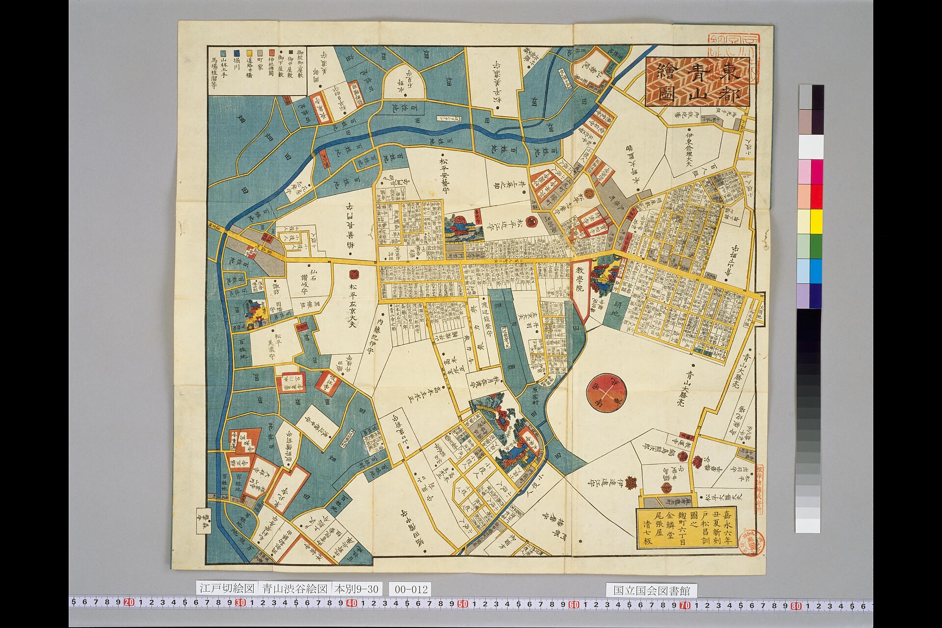
Kiriezu maps help show the relationship between roads, estates and settlements on Edo’s western edge, but they are not modern survey maps. Their orientation, scale and symbols vary, so they are most useful for understanding broad spatial relationships rather than fixing every feature to a present-day address.
Railways and the creation of Harajuku Station
Harajuku Station opened in 1906 on the line that became today’s Yamanote Line. The station changed the area’s accessibility before Harajuku had become a major commercial destination. Railways brought residents, worshippers and visitors into a landscape that was still partly suburban, and later made it possible for youth cultures and retail districts to draw customers from across metropolitan Tokyo.
The station’s importance grew dramatically after the creation of Meiji Jingu. Harajuku became both a neighborhood station and a ceremonial gateway. That double role—everyday mobility beside monumental movement—remains visible in the contrast between the compact station area and the broad approaches beyond it.
Meiji Jingu and the remaking of the landscape
Meiji Jingu was founded in 1920 to enshrine Emperor Meiji and Empress Shoken. Its forest was not an untouched ancient woodland. Specialists planned a long-term woodland ecosystem, and trees donated from across Japan were planted to develop into a self-sustaining forest over generations. The result now feels natural because the design anticipated ecological change over a century.
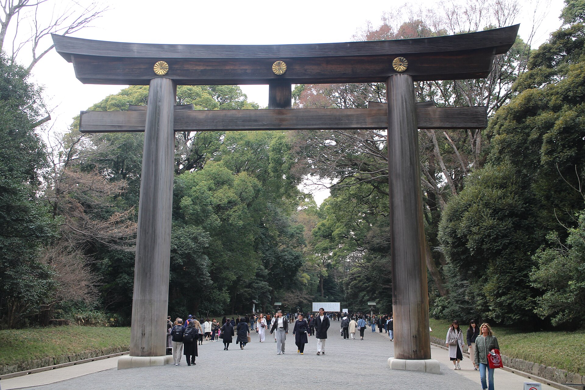
Omotesando—literally the main approach—provided a grand axis toward the shrine. The shrine, forest, avenue and station together reorganized movement on a scale far beyond the old village roads. Harajuku was no longer simply a local settlement beside fields; it had become one of the capital’s principal ceremonial landscapes.
Earthquake, urban expansion and the interwar district
After the Great Kanto Earthquake of 1923, population and investment shifted toward western Tokyo. Safer-seeming upland districts and improving rail access encouraged residential growth. Omotesando developed as a prestigious avenue, while smaller streets retained more varied buildings and land parcels. The district’s later ability to support both major architecture and small independent shops grew from this uneven urban fabric.
War damage and occupation
Air raids devastated large areas of Tokyo, and Meiji Jingu’s main buildings were destroyed in 1945 before being rebuilt after the war. Nearby former military land at Yoyogi then entered a new political order. Occupation authorities requisitioned the site and developed Washington Heights, a controlled residential complex for U.S. military personnel, civilian employees and their families.
Washington Heights beside Harajuku
Washington Heights was not an ordinary Japanese suburb. It was a restricted enclave of detached houses, lawns, curving streets and community facilities created amid Tokyo’s severe postwar housing shortage. Its low-density American-style landscape stood in sharp contrast to nearby Japanese neighborhoods.
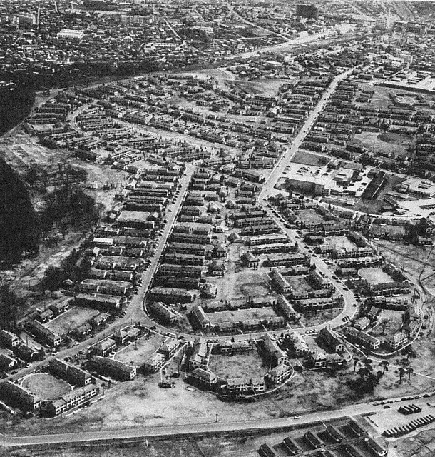
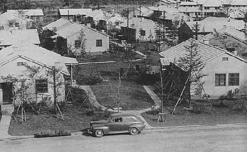
American goods, clothing, music and domestic styles were visible through workers, businesses and nearby cultural contact. Yet Washington Heights did not single-handedly create Harajuku fashion. The later district emerged from many channels: railway access, postwar retail, designers, foreign residents, magazines, music scenes and the reuse of streets after the occupation enclave disappeared.
Land return and the 1964 Tokyo Olympics
Japan regained sovereignty in 1952, but Washington Heights remained under U.S. use until negotiations linked its return to the 1964 Tokyo Olympics. The former housing area became the main Olympic Village, while new venues and roads transformed adjacent land. The change occurred in stages: agreement, relocation, return, adaptation and redevelopment.
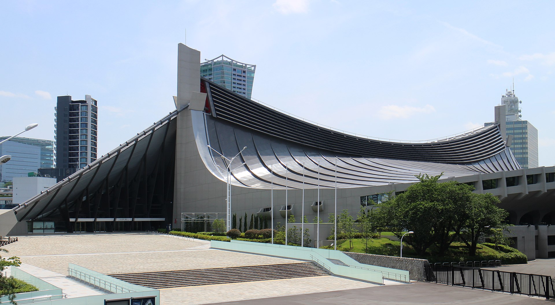
Kenzo Tange’s Yoyogi National Gymnasium gave the transformation an architectural symbol. Its suspended roof expressed technical ambition beside land recently recovered from occupation use. The gymnasium is adjacent to, not inside, Yoyogi Park. After the Games, the wider former village area was divided among the park, the National Olympics Memorial Youth Center, NHK facilities, roads and other uses. Yoyogi Park opened in 1967.
From postwar streets to a fashion district
Harajuku’s postwar cultural identity formed along several different urban stages. Omotesando offered architecture, galleries, cafés and eventually international luxury retail. Central Apartments, completed in the late 1950s, became associated with photographers, designers, editors and other creative workers. The surrounding streets supported boutiques and studios that benefited from proximity without requiring the scale of the main avenue.
From the 1970s onward, weekend pedestrianization around the area gave young people room to gather, perform and be seen. Music scenes, fashion tribes and magazine coverage turned public appearance into a form of cultural production. Laforet Harajuku, opened in 1978, became an important platform for youth-oriented fashion, while Takeshita Street developed a dense ecosystem of small shops aimed at younger customers.
Takeshita Street, Omotesando and Cat Street
These three spaces are often grouped under the name Harajuku, but they work differently. Omotesando is a broad prestige avenue whose scale supports major architecture and flagship stores. Takeshita Street is narrow, intensely commercial and shaped by small-frontage retail, fast turnover and heavy pedestrian flows. Cat Street offers a looser sequence of shops and side streets along the former upper Shibuya River corridor, linking Harajuku toward Shibuya.
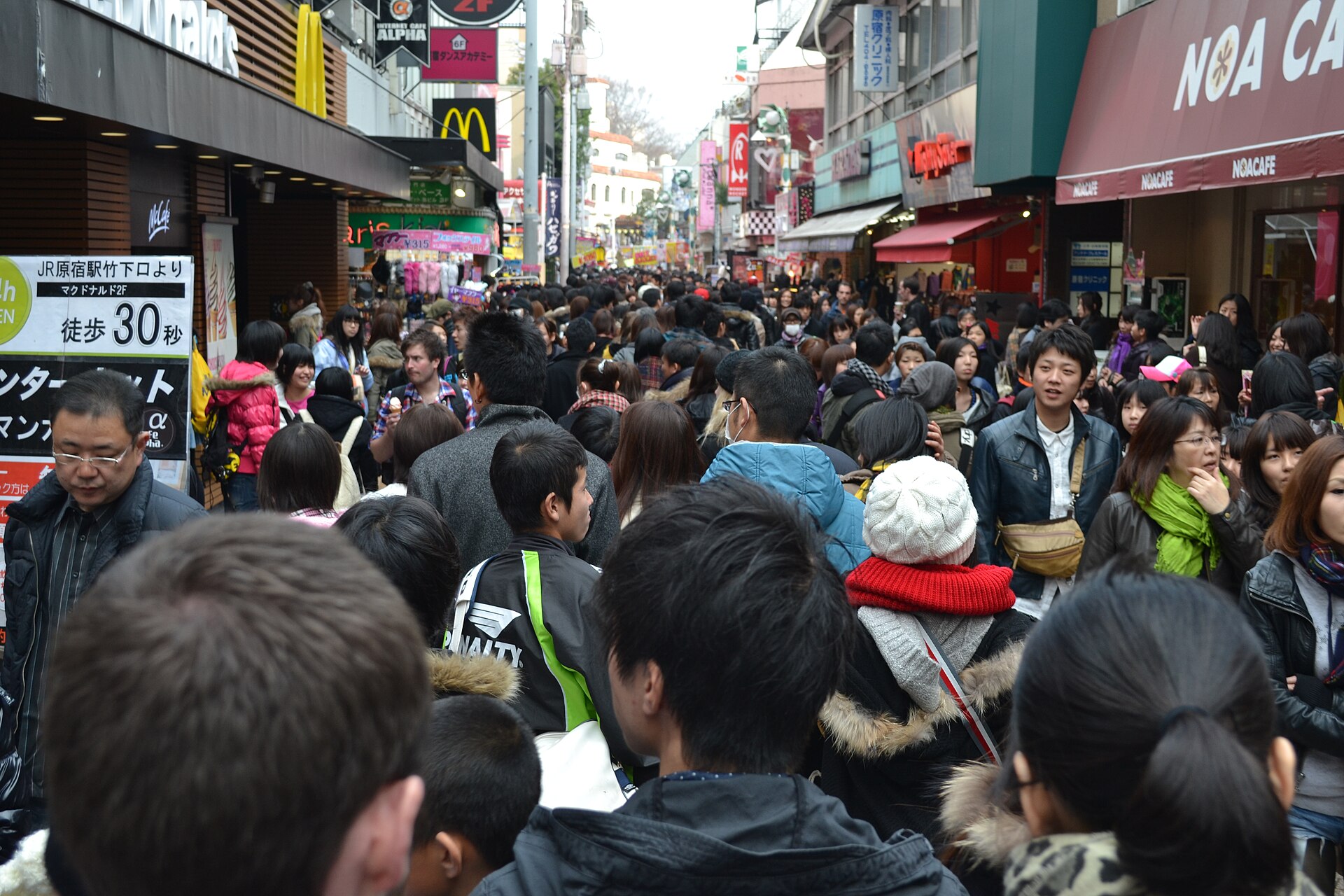
The differences matter because fashion culture needs varied spaces: prominent avenues for display, small shops for experimentation, affordable meeting places, and walkable streets where people can observe one another.
Street fashion, magazines and the global image of Harajuku
Harajuku fashion has never been one style. Successive scenes included rockabilly performers, designer and boutique cultures, kawaii aesthetics, Lolita, decora and many hybrids that resisted neat labels. Street-snap magazines were crucial because they converted fleeting outfits into an archive and a distribution system. FRUiTS, founded by photographer Shoichi Aoki in 1997, became especially influential internationally by presenting people encountered on the street rather than only professional models.
Global media often compressed these diverse generations into a single image of eccentric “Harajuku girls.” The local history is richer. Styles changed as rents, retail platforms, school cultures, music, magazines and online media changed. The street remained important, but social media allowed Harajuku looks to circulate without requiring every participant to belong to one physical scene.
Commercialization, tourism and Harajuku today
Harajuku is now both a real neighborhood and a global brand. International labels use Omotesando’s visibility; tourists seek Takeshita Street’s compressed spectacle; independent retail and cafés continue to adapt in backstreets. Redevelopment repeatedly replaces buildings and changes rents, while digital platforms accelerate the life cycle of trends. The district’s history is therefore not a story of authentic youth culture simply being replaced by commerce. Youth culture, media and commerce were intertwined from the beginning, although the balance of power has shifted.
What historical traces can be seen today?
- Meiji Jingu: the planned forest and monumental approach created in the early twentieth century.
- Harajuku Station and the rail corridor: the transport structure that made the district metropolitan rather than local.
- Omotesando: the shrine approach transformed into an architectural and retail axis.
- Cat Street: a pedestrian corridor related to the culverted upper Shibuya River, though not a literal preservation of every former river curve.
- Yoyogi National Gymnasium and Yoyogi Park: evidence of land return, Olympic redevelopment and post-Games public use.
- Slopes and side streets around Jingumae: reminders of the older upland-and-valley landscape beneath the modern shopping district.
Timeline
- Medieval period: roadside settlement traditions develop along routes west of the future city.
- Edo period: Harajuku and Onden remain village landscapes on Edo’s western edge.
- 1906: Harajuku Station opens.
- 1920: Meiji Jingu is founded; the shrine forest and approach reshape the district.
- 1923 onward: western Tokyo grows after the Great Kanto Earthquake.
- 1945: wartime destruction is followed by occupation and land requisition.
- Late 1940s–1960s: Washington Heights occupies the Yoyogi side.
- 1964: the Olympic Village and Yoyogi National Gymnasium transform the area.
- 1967: Yoyogi Park opens.
- 1970s–1990s: boutiques, pedestrian culture, music and magazines establish Harajuku’s fashion reputation.
- Twenty-first century: tourism, global brands, redevelopment and social media continue to remake the district.
How Harajuku’s land use changed
| Period | Major land use | Main movement | Public image | Visible trace |
|---|---|---|---|---|
| Medieval–Edo | Roadside village, fields and estates | Local roads and foot travel | Rural edge of the capital | Topography and street alignments |
| Meiji–Taisho | Railway, shrine and residential growth | Train and ceremonial approach | Shrine gateway | Station, Meiji Jingu and Omotesando |
| Occupation | Restricted U.S. housing | Controlled road access | American enclave | Documentary traces; later site divisions |
| 1964–1967 | Olympic village, arenas and park conversion | Metropolitan roads and event flows | Modern national showcase | Gymnasium, bridges and Yoyogi Park |
| Late twentieth century | Boutiques, youth retail and creative workplaces | Rail and pedestrian movement | Fashion and music district | Takeshita Street, Laforet and backstreets |
| Today | Tourism, global brands and mixed retail | Rail, walking and digital circulation | Global “Harajuku” brand | Constantly renewed commercial landscape |
Frequently asked questions
Was Harajuku really a post town?
Its name is associated with an older roadside settlement or stopping place, but Harajuku was not one of the formal post towns of the Tokugawa shogunate’s Five Highways.
When was Meiji Jingu built?
Meiji Jingu was founded in 1920. Its forest was deliberately planned and planted to mature over generations.
What was Washington Heights?
It was a restricted U.S. military family housing complex built on former Japanese military land beside Harajuku during the occupation and post-occupation period.
How did the 1964 Olympics change Harajuku?
The return of Washington Heights enabled the Olympic Village and adjacent Yoyogi venues. Roads, public space and the district’s international visibility changed, and Yoyogi Park opened three years later.
Why did Harajuku become a fashion district?
Rail access, varied street types, postwar creative networks, boutiques, pedestrian gathering, magazines, music and affordable small retail spaces combined over decades.
What is Cat Street’s connection to the Shibuya River?
It follows a corridor associated with the culverted upper Shibuya River. The present street is a modern urban route rather than a perfect outline of the old channel.
What historical places can visitors still see?
Meiji Jingu, Omotesando, the station and rail corridor, Cat Street, Yoyogi National Gymnasium, Yoyogi Park and the area’s slopes together reveal the district’s layered history.
Sources and references
- Meiji Jingu, official history and forest information
- Japanese Olympic Committee, Tokyo 1964 historical materials
- Tokyo Metropolitan Park Association, Yoyogi Park
- Shibuya City Library, local history resources
- National Diet Library Digital Collections, Aoyama and Shibuya kiriezu maps and related historical materials.
Related stories
Read Before Yoyogi Park: Washington Heights and the 1964 Olympics for a closer look at the military housing, Olympic Village and park transition.
Explore more neighborhood histories
Browse the Neighborhood Histories directory to see how other Tokyo districts were shaped by roads, waterways, institutions and redevelopment.
Walk Tokyo with TimeWalk Japan
Harajuku becomes more legible when you move between its forest, station, avenues, slopes and backstreets. Explore TimeWalk Japan’s Self-Guided Walks and Stories for more ways to read the city through its surviving landscapes.