Today, Yoyogi Park feels open, green and informal: runners circle broad paths, families spread blankets beneath mature trees, and crowds cross between Harajuku, the park and the great sweep of Yoyogi National Gymnasium. Yet before the park opened on October 20, 1967, this was not one continuous public landscape. The wider Yoyogi area had successively contained the Imperial Japanese Army’s Yoyogi Parade Ground, a restricted U.S. military housing complex called Washington Heights, and the main Olympic Village for the 1964 Tokyo Games. Parts of the former site were then divided among Yoyogi Park, Yoyogi National Gymnasium, the National Olympics Memorial Youth Center, NHK facilities, roads and other public uses. The boundaries never matched perfectly. Even the well-known Olympic Memorial Lodge is no longer an untouched 1940s survivor: the old structure was dismantled in 2025, and a reconstructed facility retaining its exterior design began operating as a cafe on April 9, 2026.
A quick timeline: what was here before Yoyogi Park?
- 1909: the Imperial Japanese Army established the Yoyogi Parade Ground.
- December 1910: officially recognized pioneering powered flights were made here by Army captains Yoshitoshi Tokugawa and Kumazo Hino.
- After 1945: the former military land was requisitioned during the Allied occupation and developed into Washington Heights for U.S. military personnel and their families.
- 1961: an agreement was reached for the return of the site in connection with preparations for the 1964 Tokyo Olympics, with Japan bearing major relocation costs.
- 1964: much of the former housing area became the main Olympic Village, while Yoyogi National Gymnasium rose nearby.
- 1965–1966: part of the former village was assigned to the National Olympics Memorial Youth Center, which began accepting trainees in 1966.
- October 20, 1967: Yoyogi Park opened.
- 2025–2026: the former Olympic Memorial Lodge was dismantled and replaced by a reconstructed facility that preserves the earlier exterior design.
Before the parade ground
It is tempting to imagine the site as an ancient version of the park, but that would project today’s landscape backward. Before large-scale military use, the Yoyogi area lay on the western edge of Tokyo’s expanding urban zone, with fields, village land and unevenly developed open ground. The modern spatial landmarks around it did not all exist at once. Meiji Shrine, for example, was completed in 1920, more than a decade after the parade ground was established. Harajuku Station had opened earlier, in 1906, but the dense commercial and fashion district familiar today emerged through later waves of urban growth.
The key point is that the park did not simply replace untouched countryside. The land was already being drawn into the political and infrastructural life of the modern capital. Its relative openness and location near new railway connections made it useful to institutions that required large, contiguous space.
The Imperial Japanese Army’s Yoyogi Parade Ground
In 1909, the Imperial Japanese Army established the Yoyogi Parade Ground, often translated as Yoyogi Military Training Ground. It served military drills, troop training, reviews and state ceremony. Calling it merely an “open field” strips away its purpose. It was part of the military geography of imperial Tokyo, a place where soldiers trained and where the state displayed organized force before officials and the public.
The parade ground was larger and functionally different from the park that occupies part of the area today. Its exact edges changed over time, and they should not be mapped directly onto the current park boundary. What matters for visitors is the change in access and meaning: a regulated military landscape eventually became, after several further transformations, an urban space used by the public.
Japan’s early powered flights over Yoyogi
The parade ground also occupies an important place in Japanese aviation history. In December 1910, Army captains Yoshitoshi Tokugawa and Kumazo Hino conducted pioneering powered flights here using imported aircraft. Official memorials commonly describe these as Japan’s first officially recognized powered flights. That wording is more accurate than claiming they were the first flight of any kind ever attempted in Japan, because definitions vary depending on whether one counts unofficial hops, gliding, foreign aviators or fully documented powered flight.
Inside Yoyogi Park, the Monument of Japan’s First Flight marks this episode. Its presence can seem surprising among fountains and trees, but it is one of the clearest reminders that the area’s open space was once valued for military experimentation as much as recreation.
War, defeat and occupation
Japan’s defeat in 1945 ended the parade ground’s original military role. Former Japanese military sites across the capital were requisitioned by the Allied occupation authorities, and the Yoyogi land was taken into occupation use. The transition was not a single-day conversion from parade ground to finished suburb. Requisition, planning, construction and occupancy unfolded in stages during the second half of the 1940s.
The site became Washington Heights, a residential complex for U.S. military personnel, civilian employees and their families. It was not principally a combat base, nor was it an ordinary Tokyo neighborhood. It was a controlled housing enclave created within the legal and political order of the occupation.
Why Washington Heights was built
The occupation brought large numbers of American personnel to Tokyo, many of whom required family housing near command, administrative and transport facilities. The former parade ground offered a rare combination: a large tract of centrally located land, few prewar civilian buildings to clear, and access to the growing road and rail network.
Its construction also exposed a stark imbalance. Much of Tokyo had been devastated by wartime bombing, and Japanese residents faced severe shortages of housing, food and building materials. Against that background, detached homes, lawns, utilities and community services for occupation families formed a conspicuous low-density enclave. The contrast should not be reduced either to simple admiration of “American modernity” or to a sentimental morality tale. It reflected the unequal distribution of land and resources under occupation authority.
An American suburb inside devastated Tokyo
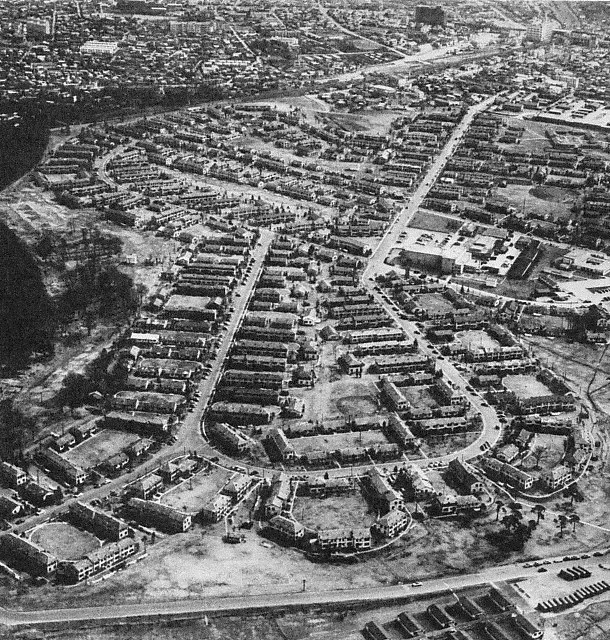
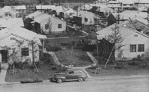
Photographs from 1947 and aerial views from the 1950s reveal a landscape unlike the dense wooden neighborhoods that covered much of Tokyo. Washington Heights contained detached houses set among lawns, curving streets, vehicle access and a low-rise plan organized for family life. Services were provided for the resident community, although surviving summaries differ in how they count individual facilities and housing units.
The visual contrast mattered. To nearby residents, the enclave presented a form of domestic space associated with occupation power: larger plots, automobiles, American goods and controlled access. Yet photographs cannot tell us every detail of how each house was occupied, nor prove that all buildings had identical plans or amenities. The strongest historical reading comes from combining images with maps, official records and the legal context of the site.
A restricted enclave, not an ordinary Tokyo neighborhood
Washington Heights was physically and institutionally separated from the surrounding city. Entry was restricted, and the area served U.S. military-related residents rather than the general Japanese public. Japanese workers entered in service, maintenance and support roles, and the enclave inevitably had economic and cultural contact with nearby districts. But that contact did not make it an open, mixed neighborhood.
This distinction is central to understanding the later symbolism of Yoyogi Park. The transformation was not simply from “American suburb” to “Japanese park.” It was from a controlled occupation landscape, reached through postwar power arrangements, into land reclaimed for a national mega-event and then redistributed among several public and institutional uses.
Did Washington Heights create Harajuku culture?
Washington Heights is often credited with introducing American clothes, music, cars and domestic styles to Harajuku and Shibuya. It was certainly one channel through which nearby residents encountered occupation-era consumption and foreign lifestyles. Shops serving foreign customers, employees moving between the enclave and surrounding streets, and the visibility of American goods all influenced the area.
But Harajuku’s later youth culture cannot be traced to a single source. Omotesando, postwar retail, the Central Apartments, foreign residents, new magazines, music scenes, railway access and the long-term redevelopment of the Meiji-jingumae district all played roles. Washington Heights contributed to a broader postwar cultural ecology; it did not single-handedly “invent” Harajuku.
Sovereignty returned—but the land did not immediately return
The Allied occupation formally ended in 1952, but U.S. facilities in Japan did not automatically disappear. Their continued use rested on the postwar security framework between Japan and the United States. Washington Heights therefore remained an American-controlled housing area even after Japan regained formal sovereignty.
Its return required negotiation. By the late 1950s and early 1960s, Tokyo’s Olympic planners urgently needed a main athletes’ village close to major venues. Washington Heights was attractive because it offered a large existing residential site near the planned Yoyogi competition complex. Yet the return was not a free gift. Japan accepted substantial responsibility for replacement housing, relocation and associated costs.
Tokyo needed an Olympic Village
Olympic organizers considered more than one candidate, including Camp Drake in Saitama. The choice involved transport time, security, proximity to venues, the capacity to house thousands of participants and the possibility of reusing existing buildings. Washington Heights had obvious logistical advantages, but selecting it was not inevitable. It depended on diplomatic agreement and the practical problem of moving the American residents elsewhere.
In October 1961, the United States agreed to return Washington Heights for Olympic use under arrangements that placed major relocation obligations on Japan. The sequence matters: agreement, relocation, return, demolition and conversion were distinct steps. The land did not simply change hands overnight.
From military housing to the 1964 Olympic Village
For the Tokyo Games, parts of the former housing complex were adapted into the main Yoyogi Olympic Village. Some houses and parts of the road pattern were reused, while other buildings were renovated, removed or newly constructed. It is inaccurate to say that every Washington Heights house became an athletes’ dormitory.
According to the Japanese Olympic Committee’s historical account, the main village covered about 660,000 square meters and could accommodate roughly 5,900 people. Those figures refer to the main Yoyogi village, not to every Olympic lodging site. Branch villages were also established at places including Oiso, Hachioji, Karuizawa and Lake Sagami for events held farther from central Tokyo. Not every athlete stayed in Yoyogi.
Life inside the Olympic Village
The village was a working international settlement, not merely a collection of buildings. Athletes ate in dining facilities, received medical care, used postal and communications services, moved to training and competition sites, and met competitors from countries divided by Cold War politics. Bicycles and internal transport helped residents move around the large site. Religious, cultural and recreational services supported daily life during the Games.
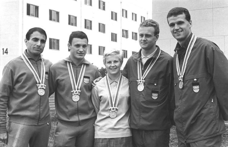
The caption identifies athletes from East Germany, but the political terminology requires care. At the 1964 Games, athletes from East and West Germany competed as the United Team of Germany rather than as separate national Olympic teams. The photograph therefore records both the social life of the village and the complicated political arrangements of the era.
Gender, hierarchy and village layout
The Olympic Village was organized by administrative zones, national delegations and gender. Men’s and women’s accommodations were separated, reflecting the regulations and social assumptions of the period. Officials, support staff and athletes did not necessarily use identical spaces or enjoy identical freedom of movement. These arrangements should be described historically rather than romanticized as a universal festival of easy international friendship.
Yoyogi National Gymnasium: architecture as national spectacle
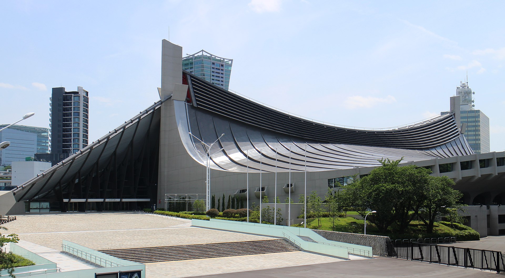
Beside the former village site, Yoyogi National Gymnasium became the most celebrated architectural symbol of the 1964 Games. Architect Kenzo Tange led the design, working with structural engineer Yoshikatsu Tsuboi and other collaborators, including engineer Uichi Inoue. Its suspension-roof system used enormous cables to create broad interior spaces and a flowing exterior profile.
The complex was more than a stand-alone masterpiece. It announced Japan’s technical ambition at the edge of land newly recovered from U.S. use. The first gymnasium hosted swimming and diving; the second hosted basketball. The two buildings should not be confused, and neither sits inside Yoyogi Park itself. They form a neighboring complex separated from the park by roads and distinct management boundaries.
Roads, bridges and transport built for the Games
The Olympic transformation extended beyond accommodation and arenas. Gorin Bridge—literally “Olympic Bridge”—helped connect the Harajuku side with the Yoyogi venues and commemorated the Games in its name and decorative program. Roads around the site were widened or reorganized, while Tokyo as a whole saw major projects including expressways, the monorail and the Tokaido Shinkansen.
Not every project was built solely for the Olympics, and their legacy was not uniformly positive. The Games accelerated plans that served long-term growth, but rapid construction also brought displacement, environmental costs and changes to waterways and streetscapes. Yoyogi was one local expression of a citywide strategy of high-speed modernization.
Oda Field and the Paralympic story
Oda Field, named after Mikio Oda—the first Japanese athlete to win an individual Olympic gold medal—served as a training ground associated with the 1964 village and remains an athletics facility today. Access can depend on schedules and management rules, so visitors should not assume that the track is always open for casual sightseeing.
Tokyo also hosted the 1964 Paralympic Games after the Olympics. The two events were separately organized and differed greatly in scale, but the Paralympics became a landmark in the history of disability sport in Japan. The Yoyogi accommodation and transport legacy formed part of the wider post-Games story, though it should not be conflated with the later institutional model used for Tokyo 2020.
After the Games: the site was divided again
When the Olympics ended, the former Washington Heights and village area was not preserved as a single memorial district. It was divided among several institutions and public projects. Yoyogi National Gymnasium remained as a sports venue. The National Olympics Memorial Youth Center occupied part of the former village. NHK developed its broadcasting center nearby. Roads and other facilities redrew the area again. Yoyogi Park took only part of the total land.
The National Olympics Memorial Youth Center
Official institutional history distinguishes several dates. In March 1965, policy was set to use part of the former Olympic Village for youth education. The center was established in April 1965 and began accepting trainees in January 1966. It later underwent organizational changes and major rebuilding, so today’s structures should not be mistaken for unaltered Olympic Village buildings.
The center remains an active education and accommodation institution, not an unrestricted open-air museum. Visitors should respect posted access rules and view the exterior or publicly accessible spaces only where permitted.
Yoyogi Park opens in 1967
Yoyogi Park opened on October 20, 1967. It was a designed urban park, not land that had simply returned to nature. Grading, planting, paths, lawns and gathering spaces created a new public landscape. Later additions and renovations—including fountains, event areas, cycling routes and changing patterns of tree growth—continued to reshape it.
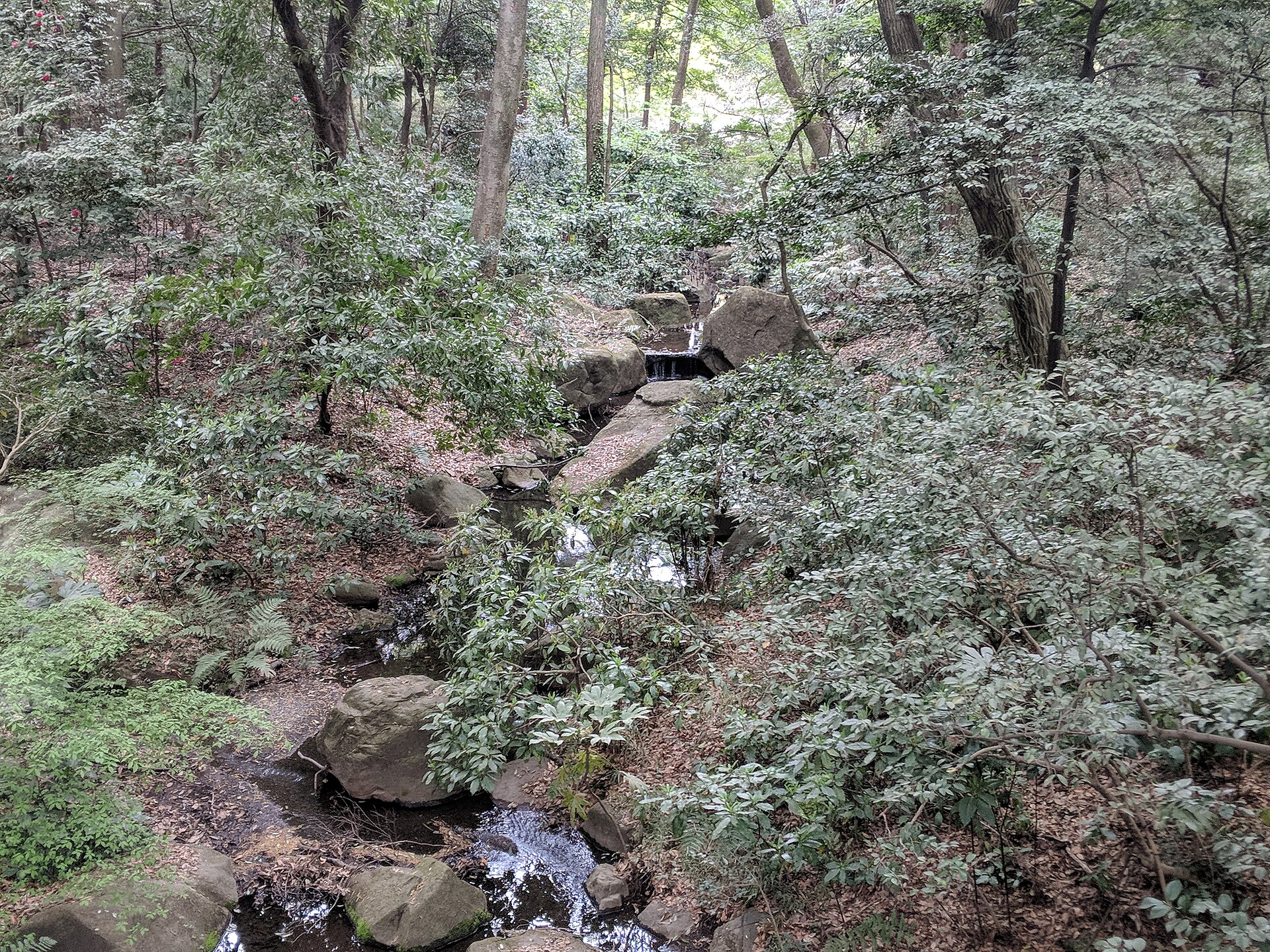
The park’s openness carries political meaning because access had changed so dramatically. Land once reserved for imperial military training and later restricted to occupation personnel became available to the general public. Yet that change did not erase the costs and power struggles that preceded it.
Did the Washington Heights street plan survive?
Some comparisons of aerial photographs and present-day maps suggest that fragments of earlier circulation patterns influenced later paths and boundaries. Mature trees may also predate portions of the park design. But it is unsafe to identify every curved park path as a preserved Washington Heights street or every old tree as an occupation-era planting.
A useful concept is an urban palimpsest: a city landscape in which traces of older uses remain beneath newer ones, partially visible but never perfectly preserved. At Yoyogi, the parade ground, housing enclave, Olympic Village and park overlap without sharing identical borders.
The Olympic Memorial Lodge: original, survivor, reconstruction
For decades, one former Washington Heights house stood inside Yoyogi Park as the best-known physical survivor of the housing era. Park histories explained that it had been used by the Dutch delegation during the 1964 Olympics and later preserved as the Olympic Memorial Lodge.
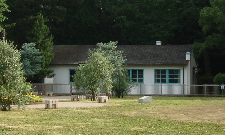
The photograph above shows the old building in 2011. It is not a photograph of the present 2026 facility. Because of deterioration, the old structure was dismantled in 2025. Tokyo then built a new facility that carries forward the exterior design. According to the official park information, it began operating as a cafe on April 9, 2026.
The correct word is therefore reconstructed, not simply “restored.” The current building is historically evocative and marks the site’s memory, but it should not be described as the last untouched Washington Heights house.
What visitors can see today
- The reconstructed Olympic Memorial Lodge and cafe: a contemporary reconstruction that retains the earlier exterior design.
- The Monument of Japan’s First Flight: a reminder of the 1910 powered flights on the former parade ground.
- Oda Field: an athletics facility connected to the Olympic legacy; access depends on current operations.
- Yoyogi National Gymnasium: best viewed from the Harajuku and park approaches; interior access depends on events.
- Gorin Bridge: an Olympic-era link and landmark near Harajuku Station.
- The National Olympics Memorial Youth Center: an active institution on part of the former village site; observe access restrictions.
- The park’s paths and open spaces: useful for understanding the scale of change, even where exact earlier boundaries are no longer visible.
A practical self-guided walk
Begin at Harajuku Station or Meiji-jingumae Station. Cross toward Gorin Bridge and look across the roads to Yoyogi National Gymnasium. Continue to the main park entrance, then walk toward the reconstructed Olympic Memorial Lodge. From there, continue through the park to the first-flight monument and toward Oda Field. A longer route can finish on the Sangubashi side near the National Olympics Memorial Youth Center.
Allow roughly 90 minutes to two hours for a relaxed walk with stops. Yoyogi Park is generally free and open around the clock, but individual facilities, event areas and construction zones may be restricted. Check official notices on the day of your visit, especially during major festivals, stadium events or bad weather.
Frequently asked questions
What was in Yoyogi Park before it became a park?
The wider area successively held the Yoyogi Parade Ground, Washington Heights and the main 1964 Olympic Village before being divided into the park and several neighboring facilities.
What was Washington Heights in Tokyo?
It was a restricted U.S. military family housing complex built on former Japanese military land during the occupation.
Was it a military base or a housing complex?
Its principal function was residential. It served military-related personnel, but it was not primarily an operational combat base.
Could Japanese residents enter?
Access was restricted. Japanese employees and authorized visitors could enter under controlled conditions, but it was not an ordinary open neighborhood.
Why was the land returned for the Olympics?
Tokyo needed a large, well-located athletes’ village. The return followed negotiation, and Japan assumed major costs for relocating the American residents.
Was the entire Olympic Village inside today’s Yoyogi Park?
No. The Olympic Village extended across land later divided among the park, youth center and other facilities.
How large was the Yoyogi Olympic Village?
The main village covered about 660,000 square meters and accommodated roughly 5,900 people, according to JOC historical material.
Did all athletes stay in Yoyogi?
No. Branch villages served events at more distant sites.
Were Washington Heights houses reused?
Some buildings and infrastructure were adapted, while others were removed, renovated or newly built. Reuse was selective, not total.
When did Yoyogi Park open?
It opened on October 20, 1967.
Is Yoyogi National Gymnasium inside the park?
No. It is an adjacent, separately managed sports complex.
Does an original Washington Heights house still survive?
The long-preserved lodge was dismantled in 2025. The current facility is a reconstruction retaining the exterior design, not an untouched original.
How long does the history walk take?
About 90 minutes to two hours, depending on stops and facility access.
Sources and further reading
- Tokyo Metropolitan Park Association: Yoyogi Park
- Tokyo Metropolitan Park Association: redevelopment of the former Olympic Memorial Lodge
- Japanese Olympic Committee: Yoyogi Olympic Village
- Japanese Olympic Committee: negotiations for the return of Washington Heights
- Japanese Olympic Committee: Yoyogi National Gymnasium
- Japanese Olympic Committee: Gorin Bridge
- Shibuya City Library: the previous Tokyo Olympics
- National Olympics Memorial Youth Center: institutional history
Walking through a layered landscape
Yoyogi’s history is not a simple progression from military land to a peaceful park. Each transition involved war, occupation, sovereignty, relocation costs, state planning and decisions made on a metropolitan scale. The 1964 Olympics opened the way for public reuse, but they also imposed a new national vision on land whose previous residents and boundaries quickly disappeared.
That complexity is precisely what makes the area worth walking. The next time you cross the lawns or follow a curving path, imagine not one vanished place but several: a parade ground, a controlled American housing district, an international athletes’ village and a newly designed public park. For more ways to read Tokyo through its streets and changing landscapes, explore TimeWalk Japan’s Cities and Neighborhoods stories.