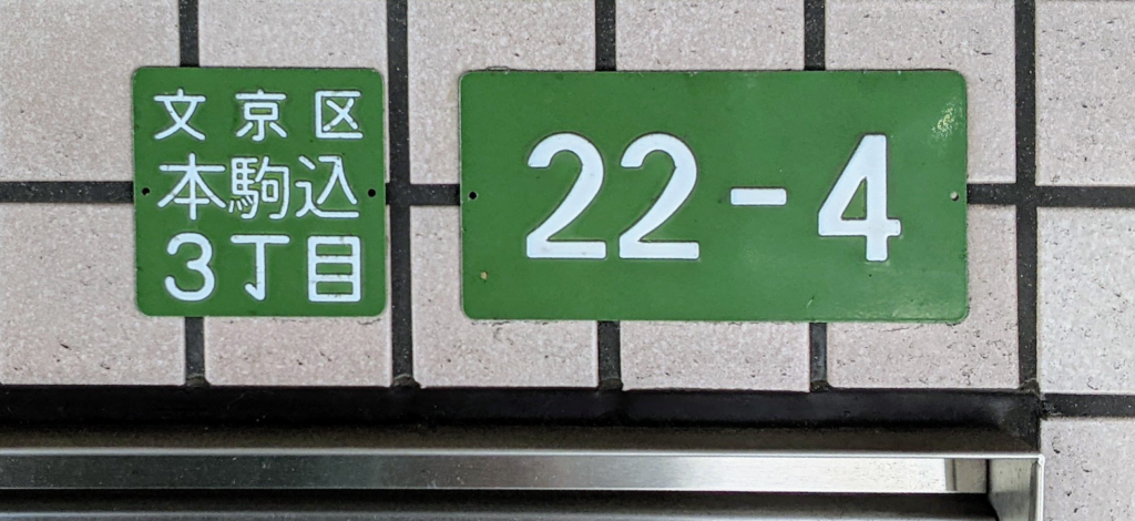
You have reached 3-22-4 Honkomagome. Your phone says the destination is beside you, but the side street has no useful name sign, nearby building numbers do not seem to form a sequence, and the entrance is around a corner. Then you notice a blue plate: Honkomagome 3-chome, block 22. A smaller plate near a doorway shows 4.
Tokyo does have named roads, especially major avenues, historic highways, shopping streets and slopes. But most addresses do not use a street name. They identify a building by its ward or city, town, chome, block and residence number—or, in some areas, by a land lot number. The address is not wrong. It divides the city differently from a street-name-and-house-number system.
How to Read a Tokyo Address in 60 Seconds
Start with an address in an area using Japan’s residence-indication system:
東京都 千代田区 霞が関二丁目 1番 6号
Tokyo-to / Chiyoda-ku / Kasumigaseki 2-chome / 1-ban / 6-goCommon compact form: 2-1-6 Kasumigaseki, Chiyoda-ku, Tokyo
| Element | What it means |
|---|---|
| Tokyo | The prefecture-level jurisdiction, officially Tokyo Metropolis. |
| Chiyoda-ku | The special ward or municipality. |
| Kasumigaseki | The town name. |
| 2-chome | A subdivision of the town, normally treated as part of the town name. |
| 1-ban | The block code in a residence-indication area. |
| 6-go | The residence number assigned for locating a building or entrance. |
| Building, floor, room | Added when needed; exact administrative treatment varies. |
| Postal code | A mail-sorting code, not a substitute for the address. |
Japanese addresses normally move from the largest area to the smallest. English or romanized forms often reverse much of that order, but there is no single format used for every purpose. Japan Post gives examples such as 1-3-2 Kasumigaseki, Chiyoda-ku, Tokyo 100-8798, Japan. A hotel, booking platform, government form or courier may request a different field order, so follow the form’s own instructions and keep the building and room number.
One warning matters immediately: do not explain every hyphenated address as “chome-banchi-go.” In a residence-indication area, 2-1-6 usually represents chome-ban-go. In a non-implemented area, the number after the town name may instead be a land lot number, often expressed with banchi. The typography can look similar while the legal structure is different.
Two Address Systems Exist at the Same Time
The central difficulty is not merely romanization. Japan uses overlapping systems created for different purposes.
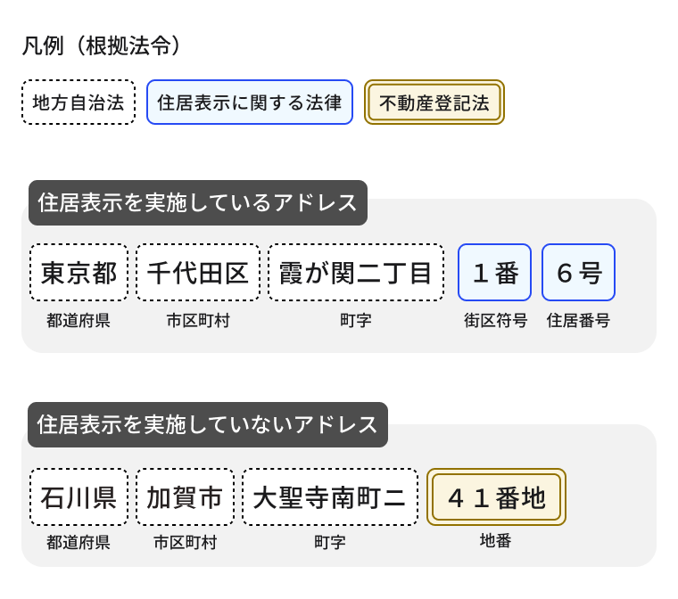
Residence-indication addresses
Under the residence-indication system, an address usually proceeds through prefecture, municipality, town or chome, block code and residence number. Tokyo commonly uses the block method: roads, railways, rivers and other durable features help define blocks; each block receives a code; and buildings receive residence numbers according to municipal rules.
Lot-number addresses
Where residence indication has not been implemented, an address may identify a place through its registered land lot number. A chiban is the number assigned to a parcel of land in the real-estate registration system. It was designed to identify land, not to guide a pedestrian along a road.
The two systems can resemble each other on an envelope, but they serve different functions. A residence number, land lot number and registered building number do not necessarily correspond directly. Tokyo is not uniform: implementation differs among municipalities and can even vary within one ward or town.
Chome, Ban, Go, Banchi and Chiban
- Chome: a numbered subdivision of a town; in an address it is generally part of the place name.
- Ban: the block code used in a residence-indication area.
- Go: the residence number used to locate a building or principal entrance within that block.
- Banchi: a conventional way to express a land lot number when it is used in an address.
- Chiban: the registered number of an individual parcel of land.
- Kaoku bango: a building number in the real-estate register, distinct from an everyday residence address.
The expression ban-go here means “block and residence number.” It should not be confused with the ordinary Japanese word bangō, which simply means “number,” as in a telephone number. English labels such as “house number” or “building number” are convenient but can hide these legal distinctions.
Why the Numbers Can Look Out of Order
A persistent claim says Japanese buildings are numbered in the order they were built. That is not a reliable explanation of Tokyo addresses.
In many residence-indication areas, a municipality sets a reference point and divides the perimeter of a block into intervals. A building’s residence number is then determined largely by the position of its principal entrance relative to that framework. Rules differ by municipality. Two neighboring entrances may therefore have numbers that jump, two buildings may share a number, or branch numbers may be added.
In a lot-number area, apparent disorder has another history. Parcels are divided, combined, converted into roads or absorbed into redevelopment. Subdivision can create branch numbers; consolidation can leave gaps. The sequence follows the documentary history of land parcels, not the route a visitor walks.
From Edo Towns to Modern Neighborhoods
Modern Tokyo’s address system is not an unchanged survival from Edo, but Edo helps explain why towns and districts remain so important to urban identity.
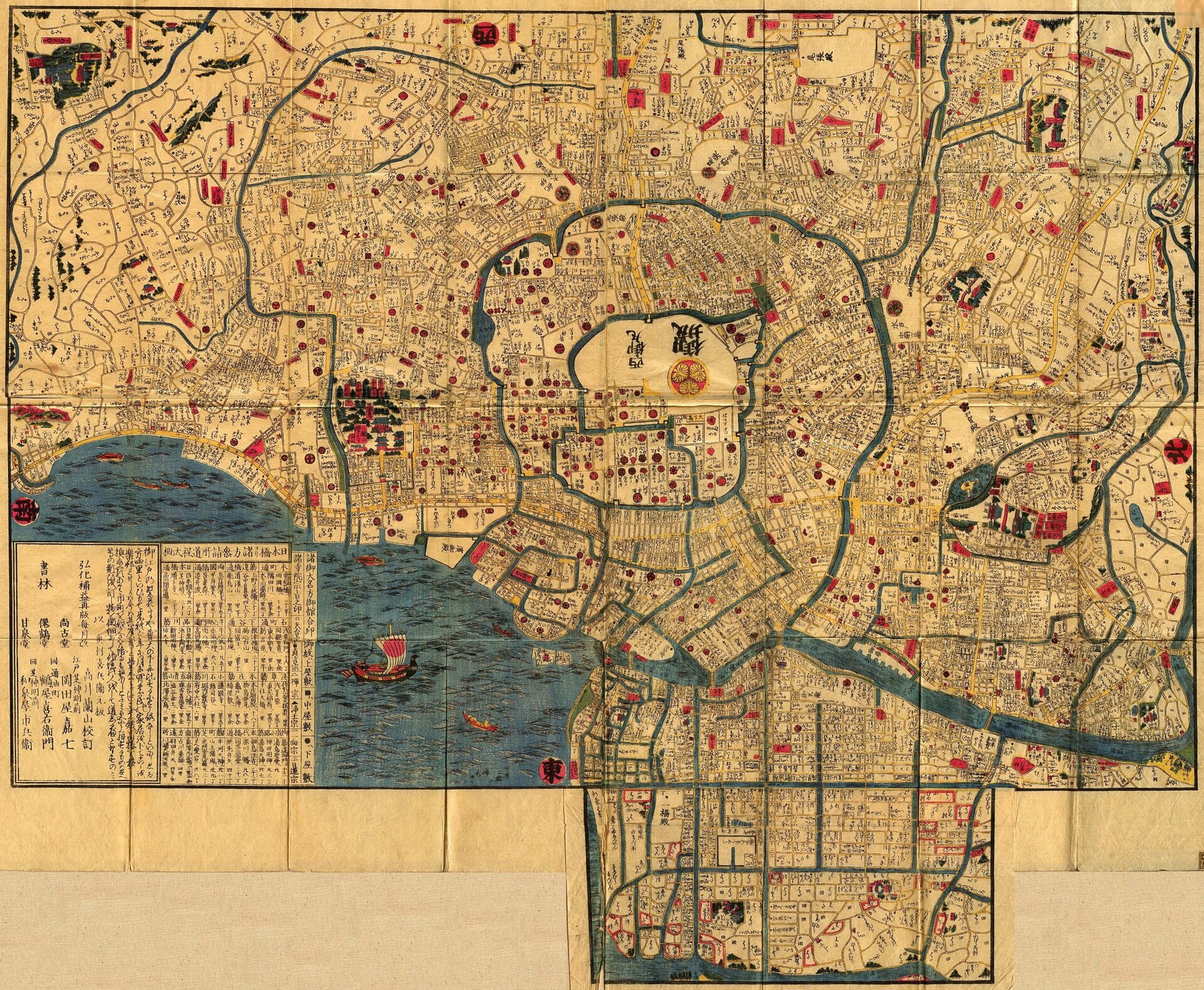
Edo was understood through the castle, moats, waterways, bridges, gates, temples, daimyo estates, commoners’ towns and named local places. In the townspeople’s districts, the cho or town was an important administrative and social unit. Edo also had named highways, streets, riverbanks, alleys and slopes, so it would be wrong to imagine a city without named routes.
What carried forward was not today’s exact numbering system but a strong habit of organizing urban space through named places and districts. The present system emerged from several layers: Edo town geography, Meiji land administration, modern municipal government and postwar residence-indication reform. For a practical introduction to comparing those older districts with the city today, see our guide to reading old Japanese maps in modern Tokyo.
Meiji Land Registration and Lot-Number Addresses
After the Meiji Restoration, tax reform, cadastral work and real-estate registration developed over time rather than appearing as one finished national system in a single year. Land was divided into registered parcels, and each parcel needed an identifier. These lot numbers became useful for taxation, ownership and legal records and were also widely used to state locations.
The limitation became increasingly visible as cities expanded. A parcel number can identify land precisely in a register while being inconvenient on the street. Subdivision, consolidation, road construction, land readjustment and rebuilding can separate numerical order from physical approach. A visitor may stand beside the correct parcel but still be far from the building’s public entrance.
The 1962 Reform: Residence Indication
Japan’s Act on Indication of Residential Address took effect in 1962. Its purpose was to establish more rational and understandable ways to indicate residences where addresses based on place names and lot numbers had become inconvenient.
The law provides a block method and a road method. Tokyo’s urban explanations usually focus on the block method: a town is divided into blocks by roads, railways, rivers and similar boundaries, then a block code and residence number identify a building. The reform did not abolish road names, and it did not convert every address in Japan at once. Municipalities implement residence indication area by area.
Tokyo Is Not One Uniform System
Official municipal pages make the uneven picture clear. Chuo City states that residence indication has been implemented throughout the ward. Shinjuku City’s information, updated on April 15, 2026, lists both implemented and non-implemented areas. Even within a familiar central ward, you cannot assume every address follows exactly the same structure or local numbering practice.
Seeing go or banchi in a fully written Japanese address can provide a clue, but travelers should not treat one word or a hyphen pattern as an infallible diagnostic. The safest approach is to use the address supplied by the venue and check the relevant ward’s official address information when the distinction matters.
The Important Exceptions: Tokyo Roads That Do Have Names
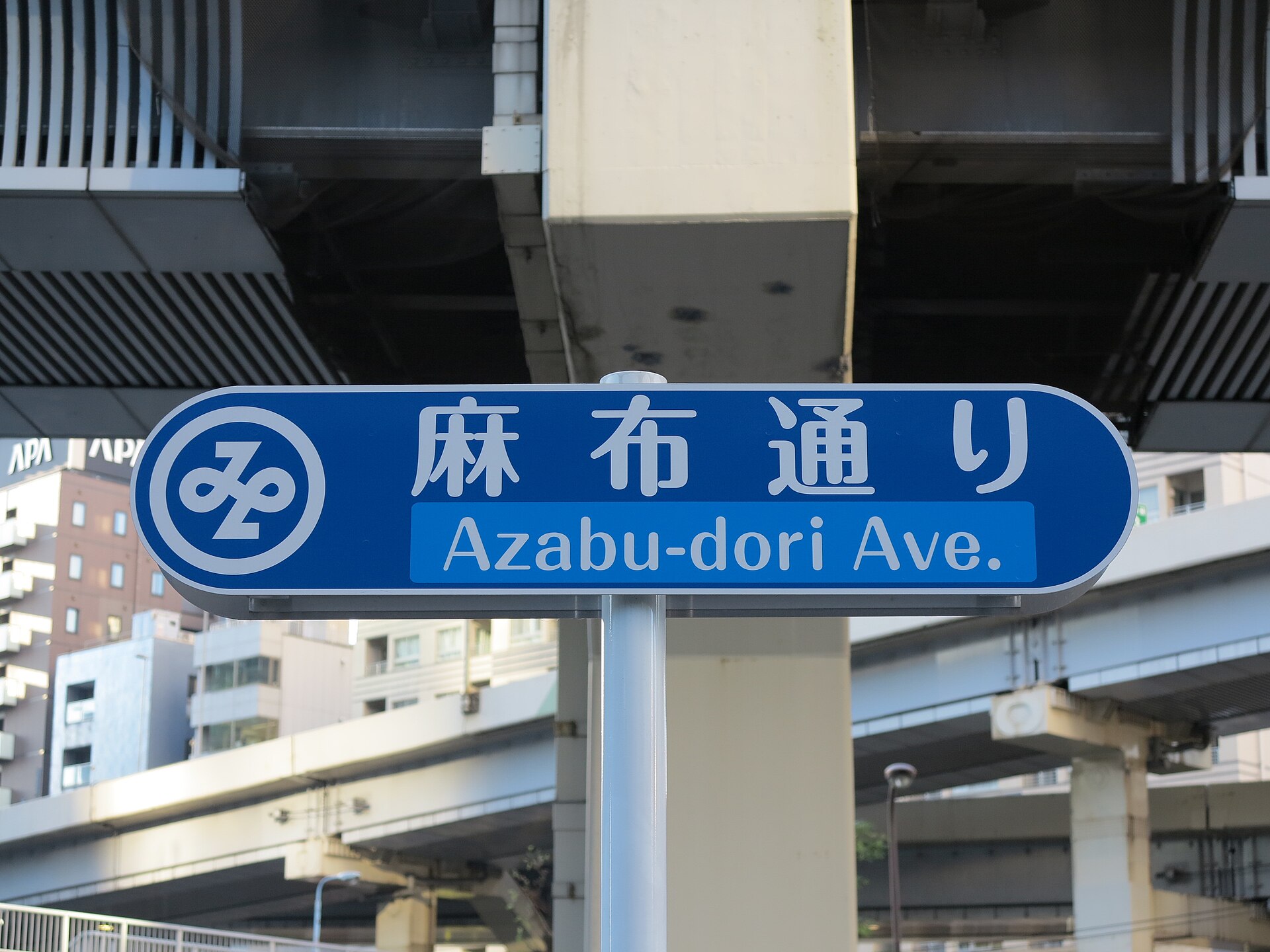
Chuo-dori, Aoyama-dori, Meiji-dori, Yasukuni-dori, Azabu-dori and Harumi-dori are widely used road names. Historic highways such as Koshu Kaido, the Tokaido and the Nakasendo remain powerful geographic references. Omotesando is both a famous avenue name and a place name. Shopping streets, yokocho alleys and named slopes also help people navigate.
These names do not all have the same legal status. A national highway number, Tokyo metropolitan road designation, officially promoted avenue name, historic highway name, shopping-street name and neighborhood nickname are different categories. A small road may also have a technical route designation without a name useful to a traveler. The essential point is simpler: named roads exist, but a building’s standard address usually does not depend on them.
How People Found Places before Google Maps
People did not navigate pre-digital Tokyo by address alone, and they did not live without addresses. They combined town names and numbers with bridges, temples, shops, intersections, stations, police boxes, telephone directions and printed maps. Businesses told customers which station exit to use. Taxi drivers relied on facility names, landmarks and specialized street knowledge. Detailed residential maps became important tools for delivery and field work.
This layered method survives. A Tokyo invitation may give a formal address, the nearest station exit, a convenience store on the corner and a photograph of the entrance. That is not evidence that the address system is useless; it recognizes that an address identifies a location while a landmark often identifies the best approach.
How to Find a Tokyo Address on Foot Today
- Confirm the ward or city and the town name.
- Check the chome, if the address has one.
- Look for a block sign showing the town and block number.
- Near the destination, look for a residence-number plate close to the main entrance.
- Confirm the building name; several buildings may share similar numbers.
- Check the floor and room or suite number.
- If the map pin is not at an entrance, walk around the public perimeter rather than cutting through private property.
- Use the venue’s nearest station exit, intersection or landmark.
- For a taxi, show the facility name, phone number and map pin as well as the address.
- For an event, verify the meeting-point photograph or coordinates.
In residential areas, avoid photographing doors or plates in a way that intrudes on residents, especially at night. Never enter a private driveway, service corridor or restricted passage simply because a map suggests it is shorter.
How to Read the Blue Address Signs
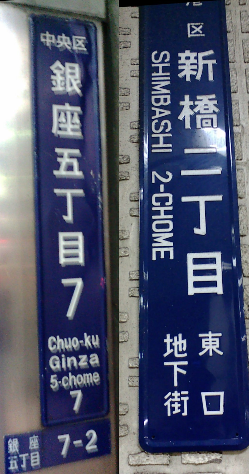
A block sign commonly shows the town, chome, block number and ward, sometimes with romanization. A smaller town-name or residence-number plate may be attached to an individual building. Do not confuse the block number on a street-corner sign with the residence number at the doorway.
Blue is common but not an absolute nationwide design rule. Color, layout and English spelling vary by municipality. Plates can also be faded, missing or hidden by plants and signs. Use them as confirmation, not as the only possible way to find the building.
Why a Map Pin Can Show the Wrong Entrance
Digital maps turn an address string into coordinates through geocoding. Depending on the data source, a pin may represent the center of a parcel, the center of a building, a site’s representative point, a registered shop location or a point on the wrong side of a large complex.
The difference matters around stations, underground malls, hospitals, hotels, office towers and redevelopment blocks. One address can cover several wings or entrances. Map services also update entrance information on different schedules. When the pin and doorway disagree, trust current public signs and the venue’s own access directions.
How to Write a Japanese Address in English
1-3-2 Kasumigaseki
Chiyoda-ku, Tokyo 100-8798
JAPAN
For international mail, Japan Post advises writing the destination country clearly and following the relevant label format. Do not translate a place name by meaning: Aoyama remains Aoyama, not “Blue Mountain.” Keep the building and unit number. Romanization may vary in long vowels, hyphens and suffixes such as -ku, -shi and -cho.
For a hotel or attraction, use the English facility name and address that the organization publishes. For a Japanese domestic phone conversation, the Japanese large-to-small order may be easier for the listener even when the words are spoken in romanized form.
Why an Address and a Land Registry Record May Not Match
- Address: identifies where a person, building or entrance is located for everyday administration and communication.
- Chiban: identifies a parcel of land in the real-estate register.
- Registered building number: identifies a building for real-estate registration.
- Postal code: helps sort mail by area.
For real estate, inheritance, registration or construction procedures, a residence address alone may not identify the required parcel or registered building. That is a specialist administrative question; confirm it with the municipality or Legal Affairs Bureau rather than inferring it from a map pin.
The Address Problem Has Entered the Digital Era
The Digital Agency’s Base Registry for Address aims to improve the shared foundation for address and location data used by government and private services. The challenge is structural: residence indication and real-estate registration are separate systems; spellings and character forms vary; and municipalities and companies have historically maintained their own datasets.
The agency released a formally verified town-and-area dataset on June 1, 2025. Its official page, last updated March 30, 2026, says work on lower-level data—block codes, residence numbers and land lot numbers—was still under consideration, including ways to connect residence-indication and lot-number information through maps. The ABR Geocoder is available to normalize address strings and add coordinates. This is progress, not proof that every Japanese address has already been unified in one complete national database.
Do Not Confuse Two “Digital Address” Projects
Digital Agency: Base Registry for Address
This is a national data-infrastructure project intended to make authoritative address and location information easier for public bodies and private services to reference and connect.
Japan Post: Digital Address
Japan Post launched its Digital Address service on May 26, 2025. It expresses a registered full address as a seven-character alphanumeric code and can reduce typing in supported services. Adoption has expanded through Japan Post tools, APIs and participating services, but it is not the same project as the government registry and it does not abolish ordinary addresses or residence indication.
Frequently Asked Questions
Do Tokyo streets really have no names?
No. Major avenues, historic highways, shopping streets, alleys and slopes often have names. The key difference is that standard addresses usually identify a town, block and building rather than using the road name.
How does a Tokyo address work?
In a residence-indication area it commonly runs from prefecture and ward to town, chome, block code and residence number. In another area it may use a land lot number after the town name.
What do chome, ban and go mean?
Chome is a numbered subdivision of a town, ban is the block code, and go is the residence number in a residence-indication area.
What is the difference between ban-go and banchi?
Ban and go identify a block and residence under residence indication. Banchi is commonly used when a registered land lot number forms part of an address.
What is a chiban?
A chiban is the official number assigned to a parcel of land in the real-estate registration system.
Why are Japanese address numbers not sequential?
Residence numbers can follow entrance position around a block, while lot numbers reflect parcel history. Subdivision, consolidation and redevelopment create gaps and branches.
Are house numbers assigned in construction order?
Not as a general rule. Municipal residence-number systems and registered lot histories explain the patterns more accurately.
Why can one building be associated with several numbers?
A site can involve a residence address, one or more land lot numbers, a registered building number and business-specific map records.
What are the blue address plates?
They are local signs showing a town, chome, block or residence number. Designs vary by municipality.
How do I find a building without a street name?
Confirm the ward, town, chome and block, then locate the residence number and building name at the public entrance. Use station exits and landmarks as approach information.
How do I write a Japanese address in English?
Use the recipient or venue’s published romanization, include the building and unit, and follow the field order required by the postal label or booking service.
Why does a map pin sometimes show the wrong entrance?
Geocoding may place the pin at a parcel center, building center or registered business point rather than the public entrance.
What is Japan’s Base Registry for Address?
It is the Digital Agency’s project to create a more reliable shared data foundation for addresses and locations.
Is Japan Post’s Digital Address replacing normal addresses?
No. It is a seven-character code for retrieving a registered address in supported services, not a replacement for Japan’s legal and administrative address systems.
Sources and Further Reading
- Digital Agency: Base Registry for Address
- Digital Agency: standardization of address and location information management
- e-Gov: Act on Indication of Residential Address
- Shinjuku City: residence indication
- Chuo City: address notation and residence indication
- Japan Post: How to Write the Address and Name
- Japan Post: Digital Address
- Tokyo Metropolitan Library: Edo town history
- Ministry of Justice: real-estate registration information
Read Tokyo One Block at a Time
The blue plate at Honkomagome is not a substitute for a missing street name. It belongs to another way of organizing the city—one that often begins with a town and narrows through a chome and block to an entrance.
That system reflects several histories at once: Edo’s town-based geography, modern land registration, rapid urbanization and the residence-indication reforms begun in 1962. The two address systems still coexist, and today’s digital projects are trying to connect data that was created for different purposes.
On your next walk, look beyond the map pin. Read the town name, chome and block plate; notice the named avenue, old highway or slope nearby; and ask why the boundary follows a river, railway or vanished moat. Tokyo’s addresses are not just instructions for delivery. They are a compact record of how the city was divided, rebuilt and remembered.
Walk Tokyo with TimeWalk Japan
Explore address plates, old town names, slopes and historic roads through our English-language Tokyo stories and walks.
Image Credits
- Featured image: Photo by TAKAHASHI Shuuji, via Wikimedia Commons, CC BY-SA 3.0.
- Address structure diagram: Digital Agency, Government of Japan, Base Registry for Address, Public Data License 1.0.
- Map of Edo, 1847: unknown author, via Wikimedia Commons, public domain.
- Azabu-Dori sign: Taichi Hiromatsu, via Wikimedia Commons, CC BY-SA 4.0.
- Ginza and Shimbashi signs: Namazu-tron, via Wikimedia Commons, CC BY-SA 3.0.