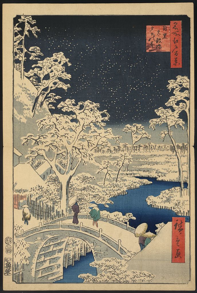
One of Tokyo’s best-known stations is not in the city district whose name it carries. Meguro Station stands in Shinagawa City, while the historic temple, river valley and neighborhoods that made “Meguro” famous lie downhill across a modern administrative border. The mistake is not on the map. It is a fossil of how the city’s center moved.
For centuries, people came to Meguro not by train but on foot, descending steep roads toward Meguro Fudo, a major Buddhist pilgrimage destination on Edo’s southwestern edge. Worshippers crossed the river, bought food and offerings, and supported a temple-town economy. Then railways placed a new gateway on the high ground and pulled shops, housing and commuters toward the station.
Modern Meguro exists because movement shifted uphill without erasing the older valley below. Its station district, steep slopes, engineered river, temple precinct and residential streets are different parts of the same story: pilgrimage routes created the first destination, water supported work in the valley, and railways rebuilt the district around commuting.
The Station Is in the “Wrong” City for a Historical Reason
Meguro Station is located in Shinagawa City, immediately beside the boundary with Meguro City. This often surprises visitors because Tokyo station names usually feel like precise addresses. In reality, many railway names refer to a wider destination or historic district rather than the municipality containing the platforms.
The name “Meguro” existed before the present ward boundary. It described a broad landscape of villages, river crossings, slopes and religious routes. When the station opened in 1885, it served that wider area from a practical site on the plateau. Later administrative lines divided the historical district, but the station kept its name.
The boundary therefore reveals the article’s central change. Older Meguro was organized around the river and Meguro Fudo. Modern Meguro is organized largely around rail access on higher ground.
A River Valley Split the Landscape into High and Low Ground
The Meguro River cuts a low corridor through the southern edge of the Musashino Plateau. From the station, streets descend sharply toward the river and rise again toward Shimomeguro. These slopes shaped where people walked, where bridges were built and which kinds of activity occupied the valley floor.
Higher ground offered relatively dry sites for roads, residences and later railway development. The low ground provided water, fields, crossings and space for productive activity, but it was also vulnerable to flooding.

The concrete banks visible today are modern flood-control infrastructure. They preserve the river’s position while concealing much of the softer agricultural and working landscape that once surrounded it.
Meguro Fudo Turned a Rural Edge into a Destination
Meguro Fudo is the popular name of Ryusenji, a Tendai Buddhist temple dedicated to Fudo Myoo, a fierce-looking protective deity represented with a sword and flames. The temple preserves a foundation tradition associated with the monk Ennin and the year 808, although its best-documented urban importance belongs to the Edo period.
By early modern times, Meguro Fudo had become one of the best-known religious destinations outside central Edo. Pilgrimage was not only prayer. A visit could combine worship, social travel, food, scenery and recreation.
That regular flow of visitors supported a monzen-machi, a settlement in front of a temple where shops and services depended partly on worshippers. Vendors sold food and offerings. Inns and teahouses served travelers. Guides, porters and craftspeople benefited from the same movement.
The Steep Road Was Part of the Experience
Gyonin-zaka descends from the station side toward the Meguro River. Its name is associated with religious practitioners, and Daienji stands beside the slope. The route shows how topography and belief worked together: the journey to the temple was physically marked by descent, crossing and ascent.
Taiko Bridge became a famous crossing below the slope. A stone image of Seishi Bosatsu records that the monk Saiun began collecting donations in 1704 while making repeated pilgrimages between Meguro Fudo and Asakusa Kannon. The funds supported riverbank works and a stone arched bridge.
The celebrated bridge later collapsed and was replaced, but its name survived. This is typical of Meguro: the physical structure changed while the route continued to organize movement.
Water Powered Work before Electricity Did
The river and local irrigation channels supported agriculture and water-powered production. Historical accounts record waterwheels in the Meguro river system, especially for rice polishing and flour milling. Some facilities later served more specialized manufacturing.
A waterwheel was not a picturesque ornament. It was machinery driven by flowing water. Farmers, millers, carriers and merchants depended on it to process goods for local use and urban markets.
This productive valley formed an important layer between the pilgrimage landscape and the later industrial city. Water attracted work before railways attracted commuters.
The Railway Pulled Meguro’s Center Uphill
Meguro Station opened in 1885 on the line that became the Yamanote Line. The new station created a fast connection to Tokyo’s growing urban network from the plateau above the old temple route.
Passengers no longer had to approach Meguro mainly through pilgrimage roads. Shops, services and housing gathered near the railway. The station did not immediately replace Meguro Fudo, but it created a competing center of movement.
From then on, the district contained two overlapping geographies: an older Meguro focused on the river and temple, and a newer Meguro focused on trains and commuting.
A Private Railway Turned Pilgrimage Country into Commuter Suburb
In 1923, the Meguro–Maruko section of the Meguro-Kamata Electric Railway opened. The line later developed into today’s Tokyu Meguro Line. Fudomae Station—originally named Meguro Fudo-mae—linked the old temple district directly to the new railway system.
Private railway companies in Japan often combined transport with real-estate development. They bought or promoted land along their lines, encouraged housing construction and created a dependable population of commuters.
The Great Kanto Earthquake later in 1923 accelerated movement away from heavily damaged central districts. New residents moved into western and southern suburbs, increasing demand for homes, schools, shops and local transport around Meguro.
Art Preserved the Temple as the City Changed Around It
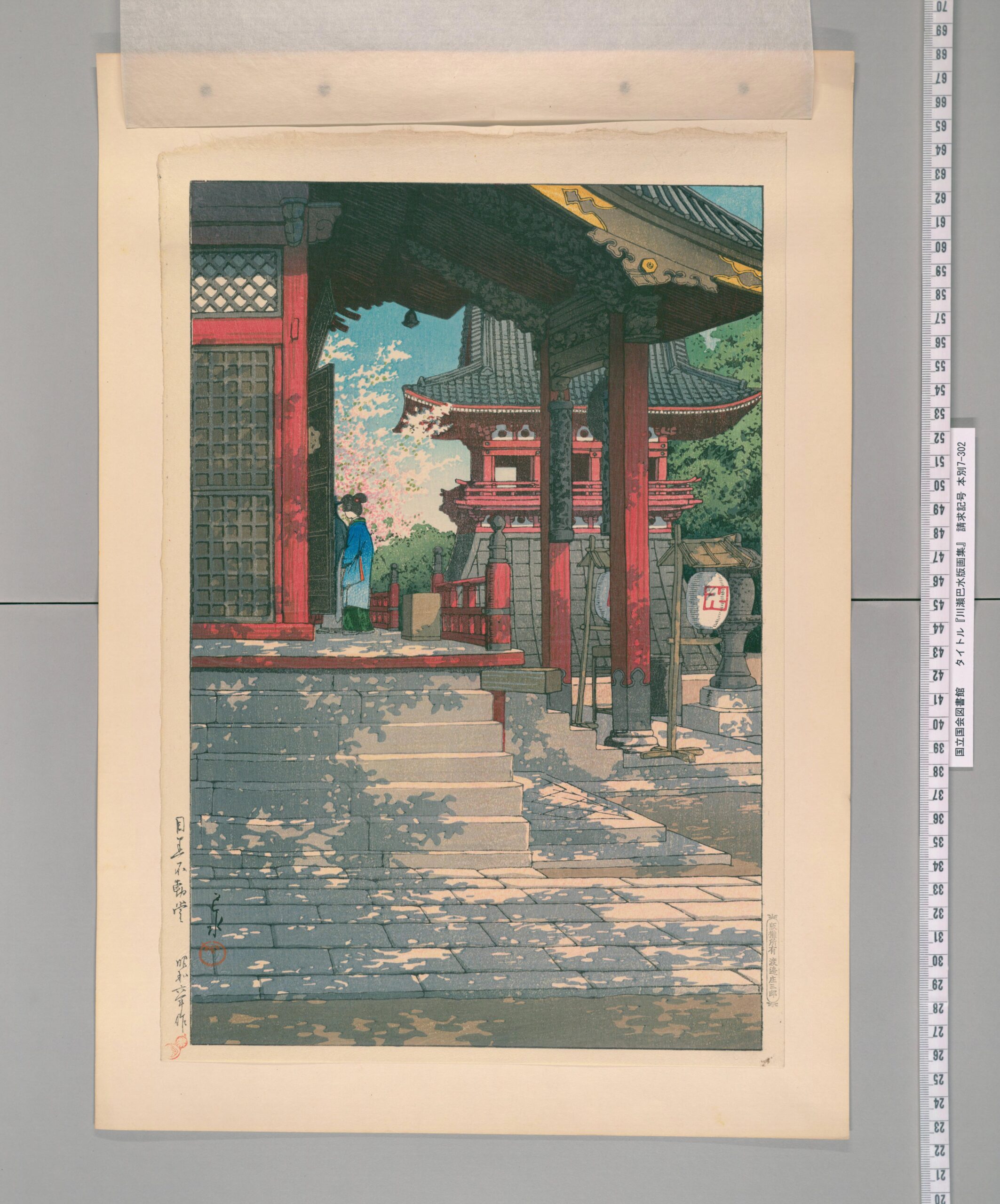
Kawase Hasui’s 1931 print presents Meguro Fudo as a place of atmosphere during rapid suburbanization. It is an artistic interpretation rather than a literal record of every building, but its date matters. The temple was already being remembered as an older landscape inside a district transformed by railways and housing.
War and Reconstruction Replaced Buildings but Kept the Routes
Air raids in 1945 damaged parts of Meguro and destroyed homes, shops and institutional buildings. The destruction was uneven, but postwar rebuilding changed much of the visible streetscape.
New construction filled the district more densely. Yet the basic framework survived: temple sites, steep roads, bridge locations, railway corridors and the river valley continued to guide movement.
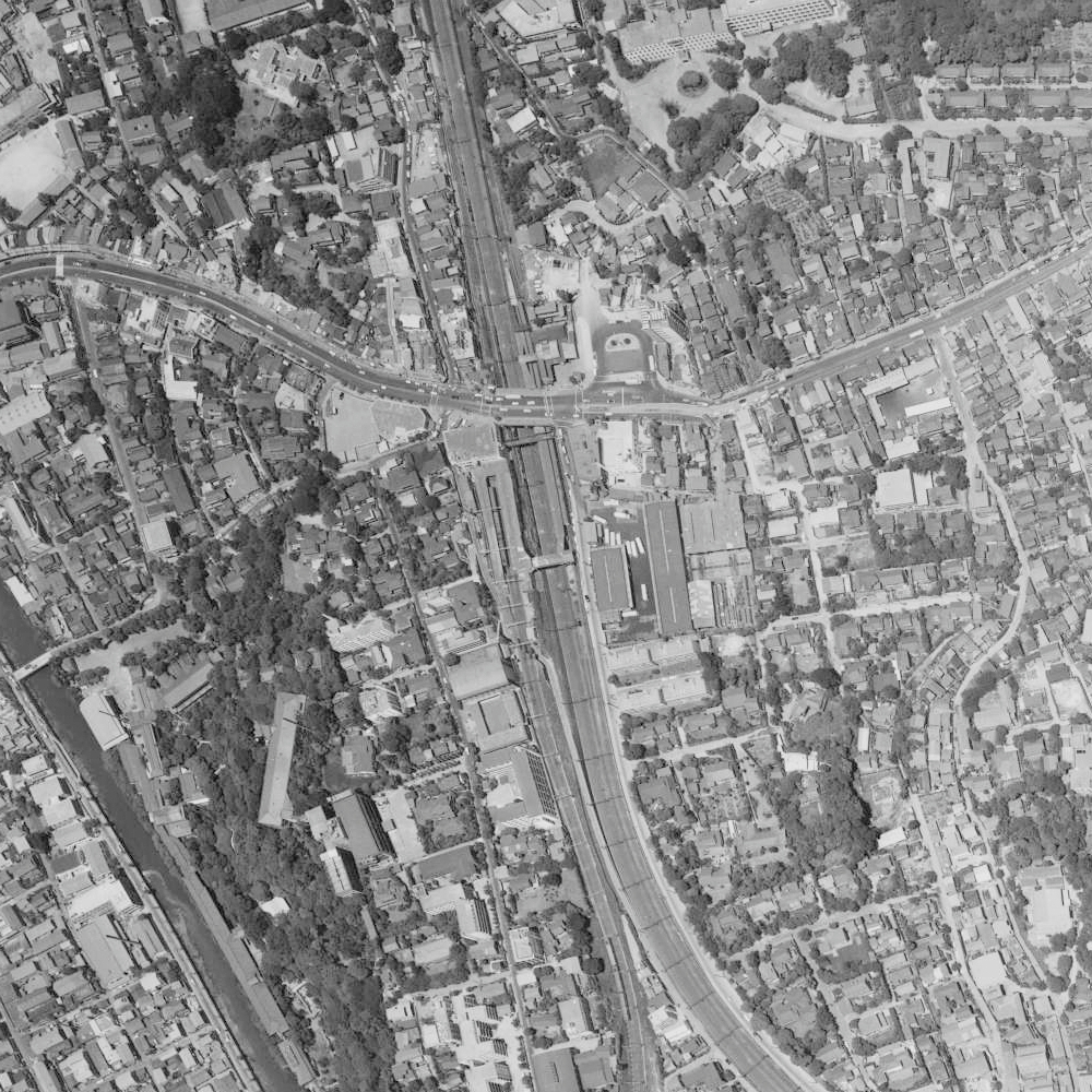
The 1963 aerial view shows a district already dominated by railways, major roads and dense construction. The older valley still structured the city, but its land was now intensely urban.
Flood Control Made the River Safer—and Less Natural
Twentieth-century flood-control and sanitation projects reinforced the riverbanks, altered channels and placed several tributaries underground. Roads and sewer systems replaced or covered smaller streams.
The open Meguro River remains the clearest visible line through the valley, but its present form is engineered infrastructure. It is both a surviving historical feature and a modern construction.
The Modern Station Became a Metropolitan Interchange
Meguro Station now connects the JR Yamanote Line, Tokyu Meguro Line, Tokyo Metro Namboku Line and Toei Mita Line. Through services carry passengers far beyond the immediate neighborhood.
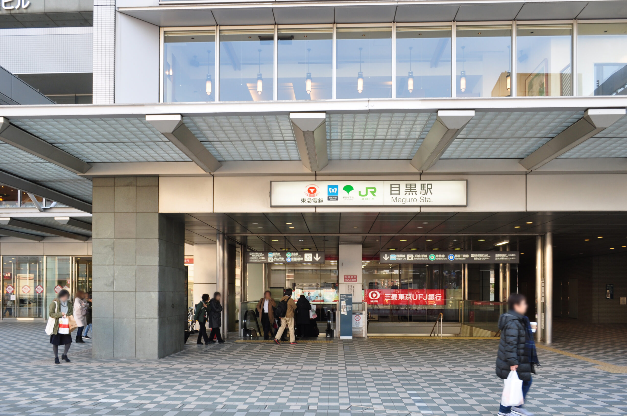
Offices, hotels, shops and apartment buildings cluster around the station. This modern concentration completed the long shift uphill from the old pilgrimage center, even though the historic name continued to cover both areas.
What to Look For Today
The Drop from Meguro Station
Walk toward Gyonin-zaka and notice how suddenly the ground falls. The slope reveals why the station, river and temple developed as separate centers.
Daienji and Taiko Bridge
These sites preserve the relationship between religious travel, donations and river-crossing infrastructure.
The Engineered Meguro River
Concrete walls and modern bridges show how flood control transformed a working river valley into metropolitan infrastructure.
Meguro Fudo and Fudomae Station
The temple and station name reveal how a pilgrimage destination was absorbed into a commuter railway network.
How Meguro’s Historical Layers Fit Together
| Historical layer | Main movement or work | Visible result today |
|---|---|---|
| River and village landscape | Farming, crossings and water use | Valley topography and river corridor |
| Temple pilgrimage | Worship, food, lodging and leisure | Meguro Fudo, Gyonin-zaka and bridge names |
| Water-powered production | Rice polishing, milling and local manufacturing | The river’s role as a former working landscape |
| Railway suburb | Commuting and residential development | Meguro and Fudomae station-centered districts |
| Modern metropolitan center | Office work, retail and through travel | Dense construction around the interchange |
Timeline
- 808, according to temple tradition: Meguro Fudo associates its foundation with the monk Ennin.
- Edo period: The temple becomes a major pilgrimage destination outside central Edo.
- 1704 onward: Saiun collects donations for riverbank works and a stone bridge.
- 1885: Meguro Station opens on the future Yamanote Line.
- 1923: The Meguro-Kamata railway opens and suburban growth accelerates.
- 1932: Meguro Ward is created within Tokyo City.
- 1945: Air raids damage parts of the district.
- Postwar decades: Reconstruction, flood control and denser housing transform the valley.
- 2000 onward: Expanded through services strengthen Meguro’s role as a metropolitan interchange.
Frequently Asked Questions
Why is Meguro Station in Shinagawa City?
The station was built on the Shinagawa side of a later administrative boundary and named for the wider historical Meguro district it served.
What is Meguro Fudo?
Meguro Fudo is Ryusenji, a Tendai Buddhist temple dedicated to Fudo Myoo. It became a major pilgrimage destination during the Edo period.
Why was pilgrimage important to Meguro?
Worshippers created regular foot traffic that supported shops, food sellers, teahouses and other services around the temple and its approach roads.
How did railways change the district?
They redirected movement from the river and temple toward stations on higher ground, encouraging commuting, shops and suburban housing.
Was the Meguro River used for industry?
Yes. The river system and irrigation channels supported waterwheels used for tasks such as rice polishing and flour milling, with uses varying by location and period.
What historical traces remain?
Gyonin-zaka, Daienji, Taiko Bridge, the river valley, Meguro Fudo, Fudomae Station and the ward boundary around Meguro Station all reveal parts of the district’s formation.
Meguro’s Center Moved, but Its Old Route Survived
Meguro first became a destination because worshippers crossed the river valley to reach a famous temple. Their movement supported roads, bridges and commerce. Water then sustained agriculture and productive work below the plateau.
Railways shifted the district’s center uphill and turned surrounding land into a commuter suburb. Later reconstruction, flood control and office development intensified the same pattern.
That is why Meguro Station can stand outside Meguro City without being wrongly named. The station inherited the name of a historical district larger than today’s border—and replaced the temple route as its main gateway.
Sources and Further Reading
- Meguro City: Meguro Fudo (Ryusenji)
- Meguro City: Gyonin-zaka
- Meguro City: Seishi Bosatsu image and bridge inscription
- Meguro City: History of the Meguro River
- Meguro City: History of the Mita irrigation system
- Tokyu: History of the Meguro Line
Related Neighborhood Histories
Continue along the same river corridor with the history of Gotanda, where the valley supported railways, printing and business. For the river’s transformation farther upstream, see the history of Nakameguro.
Walk Tokyo’s Hidden Structure with TimeWalk Japan
Meguro’s history becomes clear when you move between the station, slope, river and temple rather than treating them as separate attractions. English-friendly and bilingual history walks are listed on the TimeWalk Japan Meetup page.