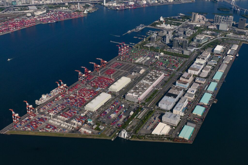
Tokyo’s futuristic island was born because four American warships terrified Japan’s military government. In 1853, Commodore Matthew Perry entered Edo Bay and exposed how easily foreign naval power could threaten the shogun’s capital. The response was urgent: build a line of artificial cannon islands in the water before the ships returned.
Those forts gave Odaiba its name—daiba means an artillery-battery site—but they did not produce the district visitors see today. Most batteries were later removed, buried or absorbed as Tokyo reshaped the bay for shipping. Warehouses and empty reclaimed parcels followed. Then, during Japan’s economic bubble, the waterfront was recast as a spectacular new urban center connected by Rainbow Bridge, automated trains and exhibition halls.
Modern Odaiba exists because Tokyo repeatedly rebuilt the same stretch of water for a different emergency or ambition: first defense, then port expansion, then logistics, then a global-city showcase, and finally a mixed district of exhibitions, offices, homes, tourism and public waterfront space. Its futuristic appearance is the newest layer of a landscape created by fear of invasion.
Quick Facts
- Neighborhood history ID: HIST-0028
- Japanese name: お台場
- Municipalities: Minato City, Koto City and Shinagawa City
- Historic origin: the Shinagawa coastal batteries begun in 1853
- Modern planning area: the Tokyo Waterfront Subcenter, principally Daiba, Aomi and Ariake
- Main stations: Odaiba-kaihinkoen, Daiba, Tokyo Teleport, Aomi and Ariake
- Key layers: Bakumatsu defense, Tokyo Port, reclamation, logistics, urban planning, exhibitions, tourism, housing and parks
Why Odaiba Looks So Different from Central Tokyo
Central Tokyo grew through centuries of dense street-by-street rebuilding. Odaiba’s modern urban blocks were laid out much later on large parcels created by reclamation and port engineering. That difference produced wide roads, generous setbacks, separated pedestrian routes, large exhibition halls and space for infrastructure that would have been difficult to insert into older neighborhoods.
Yet the apparent blank slate was never truly blank. Channels, wharves, buried battery sites, property boundaries and transport reservations already structured the waterfront. The modern plan had to work with land created for earlier port and logistics purposes. Even its spectacular bridges and railways were responses to the basic problem that reclaimed districts remained physically detached from established Tokyo.
What “Odaiba” Means—and Which Area the Name Covers
The Japanese word daiba means a place for artillery batteries. The honorific form O-daiba—literally “the honored batteries”—became associated with the shogunate’s defenses and eventually supplied the modern place-name. In strict historical usage, the Shinagawa Batteries were individual fortifications built in the waters off Shinagawa. In today’s addresses, Daiba is a neighborhood in Minato City. In popular tourism, “Odaiba” often includes nearby Aomi and Ariake in Koto City, and sometimes Higashiyashio in Shinagawa City.
The Tokyo Metropolitan Government’s Waterfront Subcenter is a planning concept rather than a synonym for every use of Odaiba. It is commonly described through four zones: Daiba, Aomi, Ariake North and Ariake South. This article uses “Odaiba” in the broad, familiar sense when discussing the connected waterfront destination, but distinguishes the historic batteries, the present Daiba neighborhood and the larger planning district whenever geography matters.
Geography Before Reclamation: The Shinagawa Coast and Edo Bay
Before modern reclamation pushed the shoreline outward, Shinagawa faced shallow Edo Bay. Tidal flats, shoals and navigable channels shaped movement toward the shogunate’s capital. The bay was both a source of food and a maritime approach to Edo. Its shallowness complicated the movement of large warships, but the appearance of Western naval power in the nineteenth century made the water approach impossible for the government to ignore.
The later waterfront crosses what was once open water, tidal ground and a series of engineered islands. This older geography explains why the batteries were placed in a line offshore, why later port builders dredged channels, and why reclamation became inseparable from the improvement of Tokyo Port.
Perry’s Arrival and the Emergency Defense of Edo
Commodore Matthew C. Perry entered Japanese waters in 1853 with steam-powered warships and a demand that Japan open relations with the United States. The Tokugawa shogunate had long regulated foreign contact, but the fleet exposed how vulnerable Edo was to pressure from the bay. Officials responded by surveying defenses, mobilizing domains and beginning a crash program of fortification off Shinagawa.
The project is closely associated with Egawa Hidetatsu, also known by the hereditary title Egawa Tarōzaemon, a shogunal official experienced in coastal defense and Western gunnery. The works were not simply symbolic. Their position was intended to obstruct or threaten hostile ships approaching the capital and to demonstrate that the bay entrance was defended.
The Shinagawa Batteries: Fortifying Edo Bay
Construction began in 1853 under extraordinary time pressure. Workers created stone-faced artificial islands by driving piles, laying timber and filling enclosures with earth and rubble. Material came from several places, including earth cut from the Gotenyama area. The first completed batteries were ready during 1854, when Perry returned.
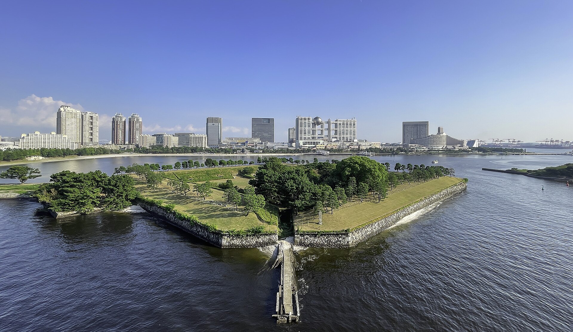
The photograph shows No. 3 Battery in 2025, not its untouched 1854 appearance. Its trees, paths, surrounding seawalls and relationship to reclaimed land are products of later preservation and urban development. What remains valuable is the fort’s broad geometry: a low polygonal platform oriented toward the bay, with an interior reached through defensive earthworks.
Planned, Completed and Surviving Batteries
Accounts of the project sometimes appear to disagree over the numbers. The usual offshore scheme counted eleven sea batteries, of which five were completed. A broader count adds the land-based Gotenyamashita Battery, producing twelve planned positions and six completed works. The difference comes from whether the shore battery is included, not from a simple factual contradiction.
The full offshore line was never finished. Some positions remained incomplete as policy and finances changed, and the urgency of the original plan diminished. Later harbor construction treated the batteries differently: some were removed, some were absorbed into reclamation, and two survived clearly enough to become nationally designated historic remains.
| Name | Status in the 1850s | Present condition or legacy |
|---|---|---|
| No. 1 Battery | Completed | Later removed or absorbed during port and reclamation works; no intact island remains. |
| No. 2 Battery | Completed | Removed as Tokyo Port and navigation facilities expanded. |
| No. 3 Battery | Completed | Preserved as Daiba Park and now connected to reclaimed land. |
| No. 4 Battery | Construction begun but not completed as originally planned | Its site was altered and incorporated into later waterfront development. |
| No. 5 Battery | Completed | Absorbed into later reclamation and port land. |
| No. 6 Battery | Completed | Remains isolated offshore; protected and not an ordinary public park. |
| Gotenyamashita Battery | Completed shore battery | Its site survives in Shinagawa’s urban landscape, distinct from the offshore forts. |
What Survived, What Was Buried and What Was Removed
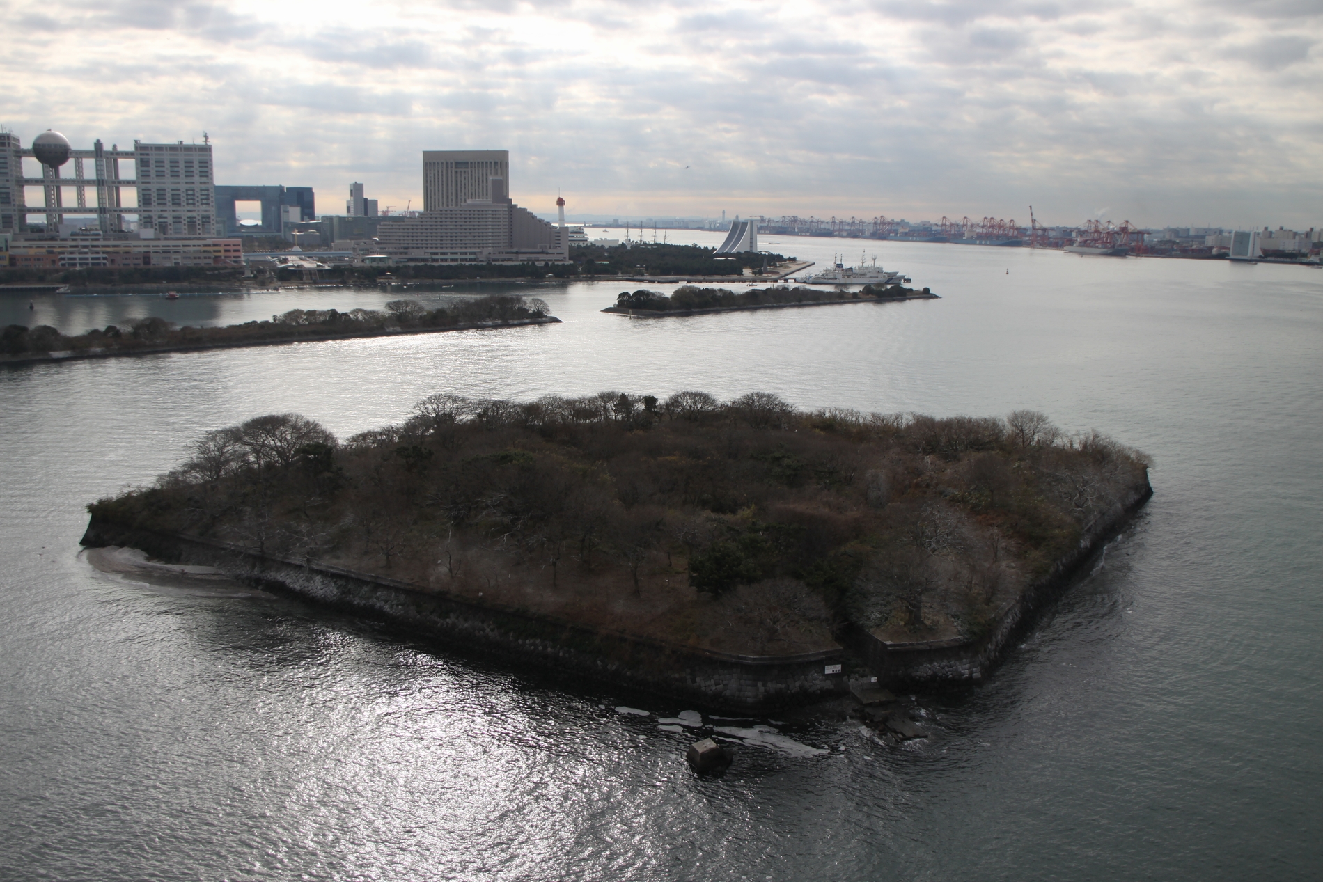
No. 3 and No. 6 Batteries do not survive in the same way. No. 3 became Daiba Park and is physically joined to the modern shoreline, allowing visitors to walk through its interior. No. 6 remains offshore, isolated in the bay. It can be viewed from the water, bridges and surrounding shore, but it is not an open public park.
The disappearance of the other batteries is itself part of the story. A fort built to control the bay could become an obstacle when the same bay was reorganized for modern shipping. Removal, burial and incorporation into reclaimed land show how military infrastructure was subordinated to harbor channels, wharves and expanding urban space.
From Military Installations to a Modern Port
After the Meiji Restoration of 1868, the batteries lost the role for which the shogunate had built them. Modern naval technology and a new national defense system reduced the strategic value of small fixed forts close to the capital. Administrative control changed, and the surrounding coast became increasingly important for railways, industry and port construction.
Tokyo long lacked the naturally deep harbor conditions of Yokohama. Port improvement therefore required dredging, breakwaters, channels and wharves. The Great Kanto Earthquake of 1923 reinforced the need for stronger metropolitan logistics, and Tokyo Port formally opened as an international trade port in 1941. War damage and postwar recovery then produced another cycle of rebuilding and expansion.
How Tokyo Bay Reclamation Created New Land
Reclamation around Odaiba was not a single tourism project. New land emerged at different times for different purposes. Dredged material from navigation channels could be used as fill; port development required wharves, warehouses and road access; urban growth created demand for industrial and public-service land; and later planning converted portions of the waterfront to offices, housing, exhibitions and leisure.
Aomi, Ariake, Higashiyashio and the port districts around Shinagawa developed through separate projects and administrative histories. Canals and harbor basins remained between blocks because the waterfront still had to function as a port. The result is a mosaic of reclaimed districts, bridges and waterways rather than one island with a single construction date.
Warehouses, Wharves and the Pre-Development Waterfront
Before the familiar skyline, much of the waterfront was a working landscape of warehouses, storage yards, roads, wharves and vacant reclaimed parcels. Large tracts existed because land had been prepared ahead of intensive urban use or reserved for port-related functions. This spacious industrial geography later made ambitious redevelopment conceivable.
The contrast is visible in a 1989 aerial photograph. Instead of today’s continuous leisure and business image, the area appears as an incomplete field of infrastructure: broad reclaimed surfaces, scattered buildings and water channels awaiting stronger connections to the rest of Tokyo.
From Port Reclamation to the Waterfront Subcenter
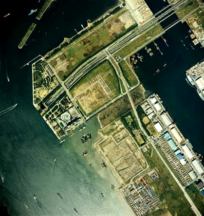
The image should not be read as evidence that the land had no history. Its roads, canals and parcels were the products of earlier port decisions. What changed in the late 1980s was the scale and purpose of the planned urban program.
The 1980s Plan for Tokyo’s Seventh Subcenter
Tokyo’s government promoted a more polycentric metropolis in which major subcenters would reduce excessive concentration in the traditional core. In the Second Tokyo Long-Term Plan of 1986, the waterfront was positioned as a seventh subcenter; a Waterfront Subcenter Development Concept followed in 1987. The plan imagined a new center for international business, information, exhibitions, culture and residence.
The timing mattered. During Japan’s asset-price bubble, expectations for land values, corporate expansion and global-city competition encouraged a large and rapid program. The reclaimed waterfront appeared capable of accommodating functions that congested central districts could not easily absorb. But its distance from existing rail networks meant that urban development depended on costly bridges, roads, utilities and transit.
Infrastructure That Made Odaiba Legible as a City
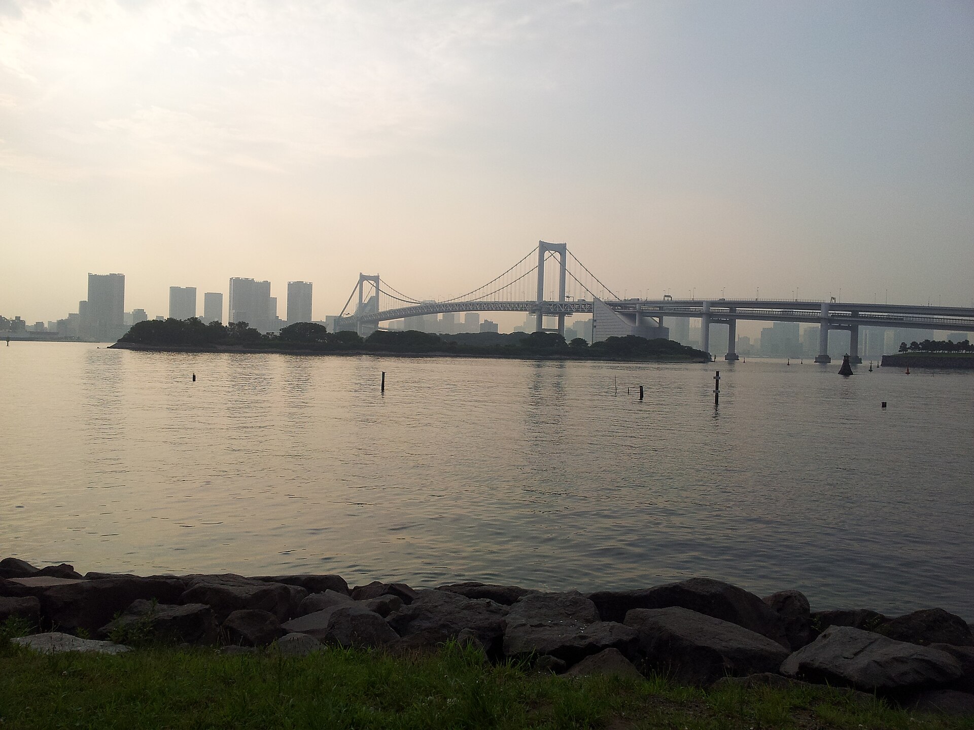
Rainbow Bridge opened on August 26, 1993, carrying the Metropolitan Expressway’s Route 11 Daiba Line, local road traffic and the future Yurikamome alignment between Shibaura and the waterfront. Its importance was structural as much as visual. It shortened the perceived and practical distance between the new subcenter and established Tokyo.
Roads alone could not create a mixed urban district. The Yurikamome opened on November 1, 1995, initially linking Shimbashi with Ariake through the waterfront. The Rinkai Line opened its first passenger section between Shin-Kiba and Tokyo Teleport on March 30, 1996. It reached Osaki in December 2002 and began through service with the JR Saikyo Line, connecting the waterfront directly with major western Tokyo centers.
The World City Expo: Ambition, Cancellation and Consequences
The planned World City Expo—often called Tokyo Frontier in English—was scheduled for 1996 as a major showcase of urban technology and the new waterfront. By the mid-1990s, however, the economic assumptions behind the waterfront program had changed. The asset bubble had collapsed, public finances were under pressure, and critics questioned the cost and priorities of the expo and associated development.
Yukio Aoshima won the 1995 Tokyo gubernatorial election after campaigning against the event. In May 1995, the metropolitan government decided to cancel it. The decision was politically dramatic, but it did not erase the waterfront subcenter. Land, utilities, roads and major facilities were already under construction or complete. The central question shifted from whether to build a showcase city on the original timetable to how to reuse sunk investment and revise the development model.
The World City Expo Cancellation and What Remained
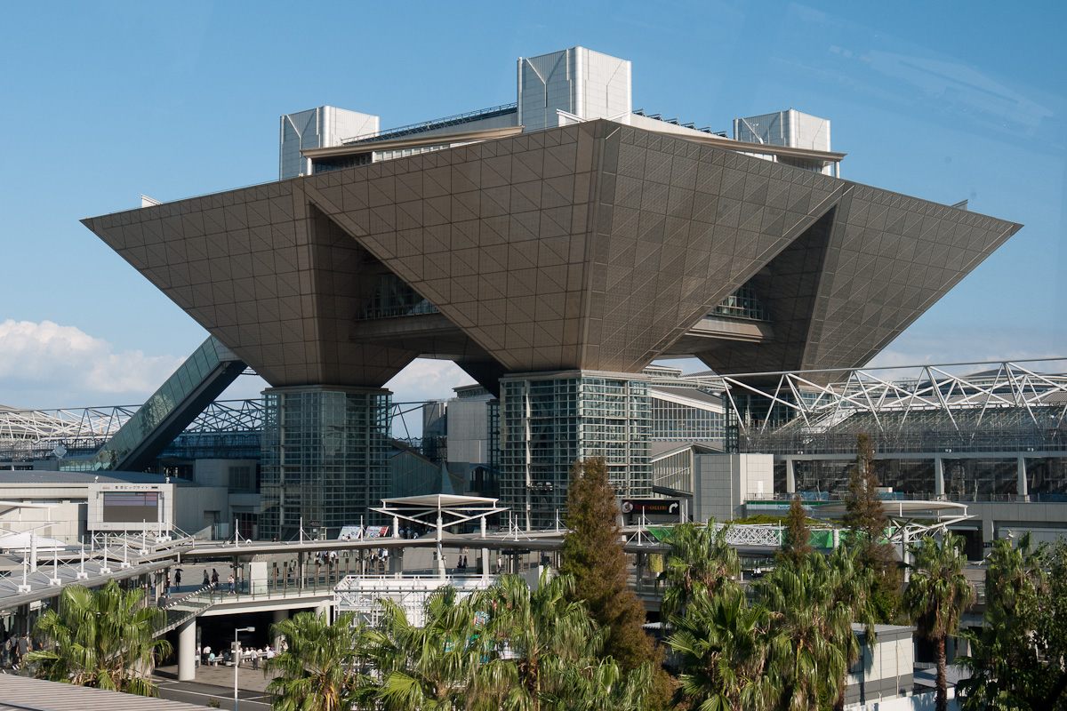
Tokyo Big Sight should not be described simply as a substitute for the canceled expo or as a leftover shell. The international exhibition center was planned and built as permanent convention infrastructure. Its main complex was completed in 1995 and opened in April 1996. It continued to support trade fairs, conventions and large events after the expo was abandoned.
The distinction explains the post-cancellation landscape. A temporary celebratory event disappeared, while permanent transport and exhibition systems remained. Development slowed and priorities changed, but the waterfront retained assets capable of attracting visitors and investment.
From Empty Reclaimed Land to a Mixed Waterfront District
After the cancellation, Tokyo revised the development program, adjusted land-use expectations and encouraged a broader mix of tenants and activities. Commercial and entertainment complexes used the open waterfront and transit access to create a destination image. Offices, television and research facilities added employment. Housing brought a resident population, while parks and promenades ensured that significant parts of the shoreline remained publicly accessible.
This shift reduced dependence on the original vision of a concentrated international business center. Odaiba and Ariake instead developed through multiple anchors: exhibitions, shopping, hotels, events, museums, media, education, offices, housing and waterfront recreation. Some individual attractions have since closed or been redeveloped, but the district’s mixed structure is more durable than any one facility.
Odaiba Today: Tourism, MICE, Residence, Parks and Port Functions
Today the broad Odaiba area combines functions that are often separated in older city districts. Ariake is a major MICE zone—meetings, incentives, conventions and exhibitions—centered on Tokyo Big Sight and related hotels and venues. Daiba and Aomi support tourism, offices, retail, events and public waterfront space. Residential development is especially visible in Daiba and Ariake.
Port and logistics functions have not vanished. Working wharves, roads, freight movement and harbor management continue around the leisure city. Disaster-prevention space, utility corridors and large public sites are also part of the landscape. Odaiba is therefore best understood as a negotiated coexistence of city and port rather than a theme park detached from Tokyo’s infrastructure.
Historical Traces You Can Still See
- No. 3 Battery: walk through the preserved fort in Daiba Park and observe its low defensive form against the modern skyline.
- No. 6 Battery: view the isolated offshore fort from Rainbow Bridge or the waterfront; it is not open for ordinary visits.
- The line of the former defenses: compare the two surviving batteries with later reclaimed shorelines to understand how the bay was reorganized.
- Rainbow Bridge: read it as a combined road-and-transit link that made the subcenter viable, not only as a landmark.
- 1980s-scale urban blocks: wide promenades, large parcels and grade-separated paths reveal planning on reclaimed land.
- Tokyo Big Sight: a permanent convention facility whose continued use outlasted the canceled expo.
- Canals and harbor basins: these show that the area remains a group of engineered waterfront districts, not one uniform island.
- Views toward Shinagawa: they reconnect modern Odaiba with the older coast from which the batteries took their name.
Timeline
| Date | Turning point |
|---|---|
| 1853 | Perry’s first expedition reaches Japan; construction of the Shinagawa Batteries begins. |
| 1854 | The first offshore batteries are completed as Perry returns. |
| 1850s | The full offshore plan is not completed; five sea batteries and the shore-based Gotenyamashita Battery are completed under the broader count. |
| Meiji period | The forts lose their original strategic role as national military and port systems change. |
| 1923 | The Great Kanto Earthquake intensifies the context for stronger metropolitan port and logistics infrastructure. |
| 1941 | Tokyo Port opens as an international trade port. |
| Postwar decades | Wharves, warehouses, roads, dredging and reclamation expand the working waterfront. |
| 1986–1987 | Tokyo positions the waterfront as its seventh subcenter and advances a dedicated development concept. |
| August 26, 1993 | Rainbow Bridge opens. |
| May 1995 | Cancellation of the planned 1996 World City Expo is decided. |
| November 1, 1995 | Yurikamome opens. |
| 1995 | The main Tokyo Big Sight complex is completed. |
| March 30, 1996 | The first Rinkai Line section opens between Shin-Kiba and Tokyo Teleport. |
| April 1996 | Tokyo Big Sight opens as an international exhibition center. |
| December 2002 | The Rinkai Line reaches Osaki and begins through service with the JR Saikyo Line. |
| 2000s–present | The waterfront continues to develop through exhibitions, tourism, offices, housing, parks and new redevelopment projects. |
Frequently Asked Questions
Why is Odaiba called Odaiba?
Daiba means an artillery-battery site. The honorific name O-daiba referred to the shogunate’s coastal defenses and became the modern place-name.
Is Odaiba a natural island or reclaimed land?
The broad Odaiba area is not one natural island. It combines surviving battery islands, multiple reclaimed districts, canals, bridges and port land created in different periods.
Why were the Shinagawa batteries built?
The Tokugawa shogunate began them after Perry’s 1853 arrival exposed Edo’s vulnerability to foreign warships approaching through the bay.
How many Shinagawa batteries were planned and completed?
The offshore scheme is commonly counted as eleven planned and five completed. Adding the shore-based Gotenyamashita Battery gives a broader count of twelve planned positions and six completed works.
Which batteries can still be seen today?
No. 3 Battery survives as Daiba Park and is accessible. No. 6 Battery survives offshore but is not an ordinary public park. Other sites were removed, buried or absorbed into later development.
Why was the World City Expo canceled?
The cancellation followed the collapse of the asset bubble, fiscal pressure, criticism of the plan and the 1995 election of Governor Yukio Aoshima, who had campaigned against the event.
Did Odaiba development stop after the expo was canceled?
No. The original program was revised, but transport, utilities and Tokyo Big Sight continued. Later growth emphasized exhibitions, tourism, offices, housing and public waterfront space.
When did Rainbow Bridge, Yurikamome and the Rinkai Line open?
Rainbow Bridge opened on August 26, 1993; Yurikamome on November 1, 1995; and the first Rinkai Line section on March 30, 1996. The Rinkai Line reached Osaki in December 2002.
What historical sites can visitors see in Odaiba today?
The principal historic site is No. 3 Battery in Daiba Park. Visitors can also view No. 6 Battery offshore and read the modern shoreline, bridge and canals as evidence of later port and reclamation history.
Is Odaiba part of Minato City or Koto City?
Both names are relevant. The Daiba neighborhood is in Minato City, while Aomi and Ariake are in Koto City. Higashiyashio is in Shinagawa City.
Related Neighborhood Histories
The batteries were built off the historic Shinagawa coast. Continue with The History of Shinagawa, or browse the Tokyo Neighborhood Histories directory.
Explore More
Browse TimeWalk Japan Stories for thematic histories and the Self-Guided Walks directory for independent routes.
Sources and References
- Tokyo Metropolitan Government Bureau of Port and Harbor, “The Roots of Odaiba Were Gun Batteries Built to Prevent Enemy Intrusion.”
- Tokyo Metropolitan Government Bureau of Port and Harbor, “History of the Port of Tokyo.”
- Tokyo Metropolitan Government Bureau of Port and Harbor, introduction to the Waterfront Subcenter.
- Tokyo Metropolitan Government Bureau of Port and Harbor, Waterfront Subcenter urban-development plan.
- Tokyo Metropolitan Library, “Illustrations of the New Gun Battery in Shinagawa.”
- Ministry of Land, Infrastructure, Transport and Tourism, Tokyo Port Office, overview of Tokyo Port planning and works.
- Metropolitan Expressway Company, Rainbow Bridge overview.
- Yurikamome, 30th-anniversary history.
- Tokyo Waterfront Area Rapid Transit, corporate history.
- Tokyo Big Sight, company and facility history.
Walk Tokyo with TimeWalk Japan
Odaiba is easiest to understand on foot, where the distance between a Bakumatsu fort, a port channel and a late-twentieth-century promenade becomes visible. See upcoming English-language history walks and events on the TimeWalk Japan Meetup page.