Shinagawa Station is not in Shinagawa—and the old highway south of it once ran beside the sea.
Step out of the modern station and Shinagawa appears to be a district of bullet trains, office towers and broad roads. Walk south toward Kita-shinagawa, however, and the city suddenly contracts into a narrow shopping street lined with temples and small businesses. This is the former Tokaido, once crowded with travelers leaving Edo for Kyoto while waves reached far closer to the road than they do today.
The apparent contradiction begins with the name. Shinagawa Station stands in Minato City, while historical Shinagawa-juku—the first official post town outside Edo on the Tokaido—lay farther south in present-day Shinagawa City. The station district, the old post town and the modern ward overlap in popular imagination, but they are different places created in different periods.
They are connected by one enduring function. For centuries, this narrow coastal corridor has controlled Tokyo’s southern approach. Highway inns, coastal batteries, Japan’s first railway, reclaimed port land, freight yards and today’s high-rise station city all reused the same gateway. Shinagawa’s modern skyline is therefore not a break with its past; it is the latest structure built along a route that has been moving people, goods and political power since the age of the shoguns.
Quick Facts
- Neighborhood history ID: HIST-0017
- Japanese name: 品川
- Main municipality: Shinagawa City, Tokyo
- Important clarification: Shinagawa Station is in Minato City
- Historic core: Kita-Shinagawa-juku, Minami-Shinagawa-juku and Kachi-shinshuku along the old Tokaido
- Main stations: Shinagawa, Kita-shinagawa, Shimbamba and Aomono-yokocho
- Key layers: coastal settlement, Tokaido post town, Bakumatsu defense, railway embankment, reclamation, port and industry, station redevelopment
Why Shinagawa Became Tokyo’s Southern Gateway
Before modern reclamation, the eastern edge of the district was a meeting place of upland, low ground, river mouths and a shallow bay. The Tokaido could follow the firm margin between hills and water while ships and fishing communities used the coast. This combination made Shinagawa both a land gateway and a maritime service center.
The same geography later attracted military defenses and railways. Coastal batteries needed command of the bay approach. The first railway needed a continuous route south from central Tokyo, and where landowners resisted an inland alignment, engineers carried parts of the line on an embankment along or over the shore. Later reclamation moved the waterfront eastward, creating space for yards, warehouses, factories, roads and offices.
Geography Before Reclamation: Ridges, Rivers and the Edo Bay Shore
The older landscape is easiest to understand as a series of north–south ridges and low coastal strips. Gotenyama and the Takanawa uplands offered elevated views over Edo Bay. The Meguro River reached the sea near the division between the northern and southern parts of the post town. Smaller streams and inlets broke the shoreline, while beaches, shallows and tidal ground supported fishing, seaweed gathering, shipping and boat transport.
Today the sea lies much farther east. The change did not happen in a single project. Railway works, successive reclamation, canal construction, port improvement and industrial land formation gradually pushed the effective coastline outward. Elevation changes, temple approaches, old road alignments and canal edges now preserve clues to former land and water.
Before the Edo Period
Shinagawa existed as a coastal settlement and transport point before Tokugawa rule. Medieval records and later local histories connect the area with the Shinagawa family, maritime traffic and settlements on both sides of the river. The evidence is uneven, but the broad continuity is clear: long before the formal post-station system, this was already a place where roads, river crossings and bay traffic met.
Shinagawa-juku: The First Tokaido Post Station Outside Edo
The Tokugawa government organized the Tokaido as the main highway between Edo and Kyoto. Shinagawa became the first of the traditional fifty-three post stations outside Edo. A post station, or shukuba, was not merely an inn village. It was an official transport institution required to provide horses, porters, lodging and administrative services for government travel.
Shinagawa-juku developed in three linked sections. Kita-Shinagawa-juku lay north of the Meguro River, Minami-Shinagawa-juku to the south, and Kachi-shinshuku was added on the northern side in 1722. The three together performed the post-town duties. Their long linear form followed the highway rather than a central square.
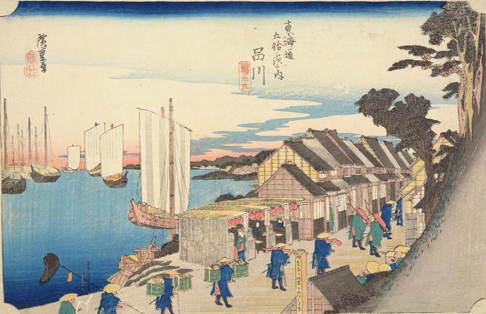
Hiroshige’s print represents the departure of official travelers from Shinagawa and the relationship between highway and shore. It is an artistic construction, not a photographic survey, but it captures how the post town was imagined as Edo’s threshold.
Inside the Post Town: Transport, Inns, Temples and Coastal Life
The transport system centered on the toiyaba, the office that organized horses, porters and official documents. A honjin accommodated high-ranking travelers such as daimyo and court nobles, while a waki-honjin served as an auxiliary. Numerous hatago inns, teahouses, shops and stables served other travelers.
Shinagawa’s economy was broader than road traffic. Temples and shrines anchored communities and attracted visitors. Boatmen, fishers, wholesalers and coastal laborers connected the town to Edo Bay. The proximity to Edo also made Shinagawa a place to assemble or disperse processions, repair equipment, buy provisions and wait for favorable conditions.
The former honjin site is now Seiseki Park. The original complex is gone, but the location near the center of the three post-town sections helps explain the settlement’s internal geography.
What the Old Tokaido Still Preserves
The old highway remains legible between Kita-shinagawa and Aomono-yokocho. Its continuity and relatively intimate street scale contrast with modern arterial roads. The present paving, storefronts and building façades are products of repeated fire, earthquake, wartime damage, road work and reconstruction; they should not be mistaken for an untouched Edo streetscape.
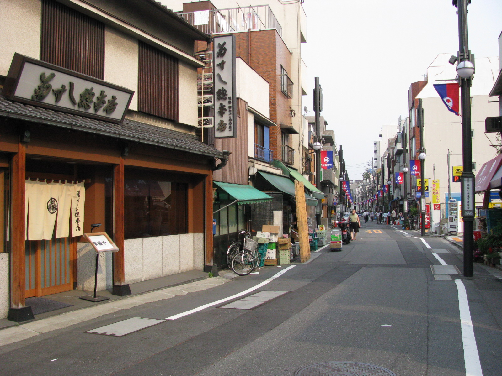
What survives most strongly is the axis itself: a long, walkable corridor with temples, former post-town sites and side streets that reveal the relationship between higher ground and the former shore.
Gotenyama, Scenic Excursions and the View over Edo Bay
Gotenyama rose above the northern approach to Shinagawa and became famous for views, villas and cherry blossoms. Its attraction depended on elevation and the open bay panorama. The area formed part of Edo’s excursion geography, where residents traveled beyond the dense city for seasonal scenery, food and temple visits.
This scenic role later collided with national defense. When the shogunate hurried to build coastal batteries after foreign warships demonstrated Japan’s vulnerability, earth and stone were taken from elevated areas including Gotenyama. Defense works altered both terrain and famous views.
Foreign Ships and the Shinagawa Coastal Batteries
After Commodore Matthew Perry’s fleet arrived in 1853, the shogunate strengthened defenses at the entrance to Edo. It began constructing artificial battery islands known as daiba in Shinagawa waters. Several planned batteries were completed or partially completed, forming a defensive line across the bay approach.
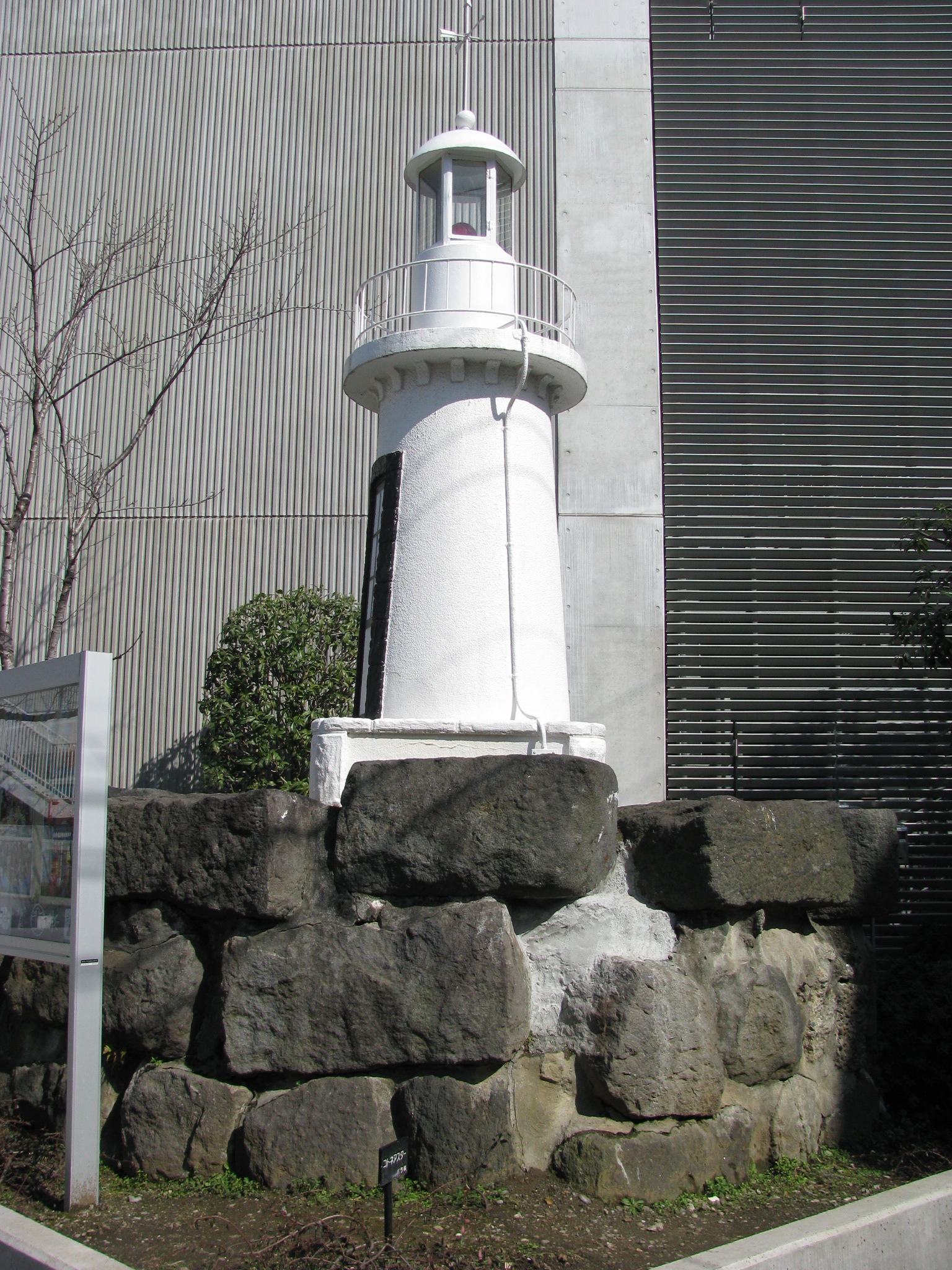
The offshore Shinagawa daiba, the later waterfront district popularly called Odaiba, and Gotenyama-shita Daiba in Shinagawa City are related but distinct. Gotenyama-shita Daiba was a shore-based battery south of the main offshore line. The present site includes surviving or reconstructed landscape elements and a replica of the former Shinagawa lighthouse; it is not an intact battery preserved exactly as built.
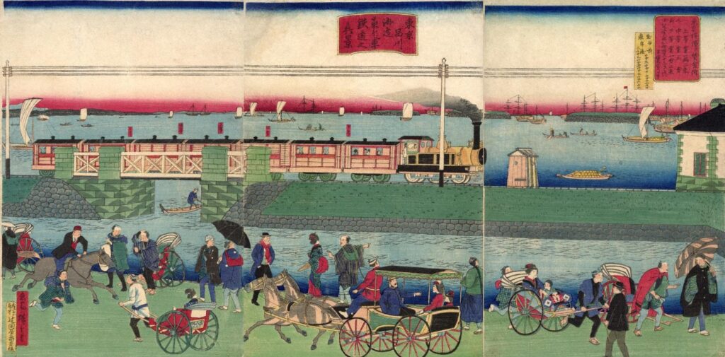
The First Railway Era: Tracks along the Shore
Japan’s first railway was developed between Shimbashi and Yokohama. Shinagawa Station began limited service in May 1872, before the formal opening of the full Shimbashi–Yokohama line in October. These stages are often compressed into one date, but the distinction matters: construction, partial operation and official opening were separate events.
North of Shinagawa, part of the route was built on the Takanawa Embankment, a stone and earth structure carrying tracks along or over the shallow shore. The alignment was an engineering response to limited coastal space and negotiations over land. It transformed the visual relationship between road and bay and established rail as the new high-capacity corridor.
The embankment later disappeared beneath reclamation. Archaeological remains were rediscovered during redevelopment associated with the former rail yard and Takanawa Gateway area. Portions have received cultural-property protection, while preservation, relocation and public presentation have been coordinated with redevelopment. The discovery made a buried shoreline infrastructure visible again.
Shinagawa Station, Rail Yards and a New Transport Geography
Shinagawa Station stood north of the historic post town and created a new transport focus. As rail traffic increased, sidings, yards, workshops and freight functions occupied large tracts along the coast. The station’s location encouraged people to use “Shinagawa” for a wider area than the old highway settlement.
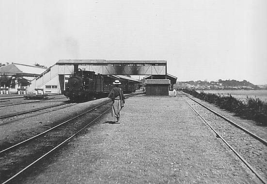
The railway did not erase the Tokaido immediately. Highway commerce, local worship and neighborhood life continued south of the station, while the rail corridor accumulated regional and national functions. Modern Shinagawa therefore developed with two centers: the historic linear post town and the expanding station complex.
Reclamation, Canals, Warehouses, Industry and Tokyo Port
From the late nineteenth century through the twentieth, reclamation moved the shoreline eastward in stages. New land supported railway facilities, warehouses, factories, roads and port-related uses. Canals separated reclaimed blocks and provided navigation and drainage. The waterfront became an engineered logistics landscape rather than a beach edge.
These uses did not all appear at once. Early railway construction preceded many large reclamation projects. Port modernization, industrial expansion and warehouse development followed different schedules and owners. Their cumulative effect, however, was to turn the old coastal corridor into a broad belt of infrastructure.
Earthquake, War and Reconstruction
The 1923 Great Kanto Earthquake damaged buildings, transport and waterfront facilities across southern Tokyo. Recovery involved rebuilding structures, improving roads and reinforcing modern infrastructure. The old post-town street survived as an axis, but its buildings and property uses continued to change.
During the Asia-Pacific War, the Shinagawa area’s railways, factories, warehouses and port connections made it strategically important. Air raids in 1945 destroyed homes, temples, shops and industrial facilities. Postwar reconstruction therefore combined emergency housing and commerce with the repair of national transport and logistics systems.
Postwar Logistics and the Expanding Waterfront
After 1945, the eastern side of the district remained strongly associated with freight, warehousing, manufacturing and transport. Expressways, containerized logistics and improved port facilities increased the scale of movement. Residential districts also expanded on reclaimed land, creating a mixed waterfront of workers’ housing, canals, schools and industrial parcels.
The Tokaido Shinkansen began service in 1964, but Shinagawa did not become a Shinkansen stop until 2003. That later change strengthened the station’s role as a national gateway. Connections to Haneda Airport and multiple JR and private lines further concentrated regional mobility.
From Rail and Industrial Land to a Business District
By the late twentieth century, changes in freight handling, industrial location and land values opened large parcels near the station for new uses. The east side—Konan—was transformed through office, hotel and public-space projects. This was not an automatic outcome of modernization. It depended on railway and public land ownership, planning decisions, infrastructure investment and demand for large office floors near a major station.
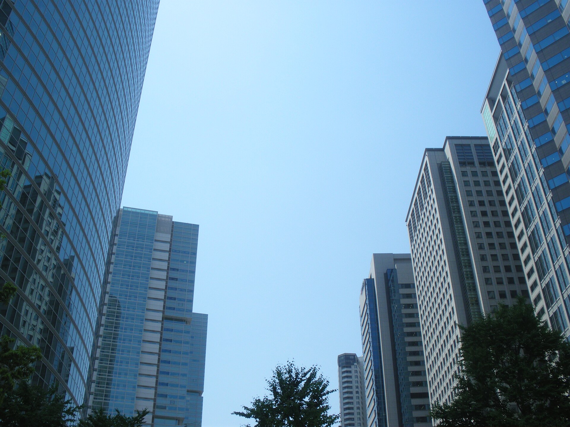
Shinagawa Intercity and Shinagawa Grand Commons exemplify the new landscape produced on the station’s eastern side. The photograph dates from 2009 and records an established phase of redevelopment rather than the latest construction.
Later Redevelopment: Takanawa Gateway and the Station District
Redevelopment has proceeded differently on the east side, west side and former rail-yard land north of Shinagawa Station. Takanawa Gateway Station opened in 2020. TAKANAWA GATEWAY CITY began its first major opening phase in March 2025, and further facilities have continued toward fuller operation in 2026. The project reuses former railway land while incorporating archaeological preservation and public interpretation of the Takanawa Embankment.
Around Shinagawa Station itself, rail and urban projects aim to improve transfers, pedestrian routes and connections between Takanawa and Konan. Plans for the Linear Chuo Shinkansen have also influenced expectations, although schedules and construction conditions remain subject to change. The modern gateway is therefore still being negotiated through transport policy, corporate investment, heritage protection and local planning.
Shinagawa Today: Station Hub, Historic Highway and Reclaimed Coast
Today’s district can be read as three parallel north–south bands. On the west are uplands and slopes. Through Kita-shinagawa and Minami-shinagawa runs the old Tokaido. Farther east are railways, canals and reclaimed land. Shinagawa Station sits north of the post town, bridging the upland and waterfront zones through a vast transfer complex.
The central historical pattern is reuse. The Tokaido selected the coastal margin; batteries militarized the bay approach; the railway occupied the same narrow route; reclamation enlarged it for port and industry; redevelopment converted large infrastructure parcels into a business and transport center. Shinagawa’s present form is the physical record of these successive decisions.
Historical Traces You Can Still See
- The old Tokaido: follow the continuous street south from Kita-shinagawa and compare its scale with nearby arterial roads.
- Seiseki Park: the former honjin site marks the administrative center of the post town.
- Temples and shrines: their sites preserve older community geography even where buildings have been rebuilt.
- Meguro River crossing: this marks the historical division between Kita- and Minami-Shinagawa-juku.
- Gotenyama slopes: elevation explains both scenic views and the later military use of the terrain.
- Gotenyama-shita Daiba site: a local reminder of the Bakumatsu defense system.
- Canals east of the old highway: they reveal the engineered waterfront created by reclamation.
- Railway corridor and station yards: large infrastructure parcels explain the scale of later redevelopment.
- Takanawa Embankment interpretation areas: archaeological remains reconnect the modern station district with the 1872 shoreline.
Timeline
| Date | Turning point |
|---|---|
| Medieval period | Coastal settlements and maritime traffic develop around Shinagawa. |
| Early 1600s | The Tokugawa government organizes the Tokaido; Shinagawa becomes its first post station outside Edo. |
| 1722 | Kachi-shinshuku joins Kita- and Minami-Shinagawa-juku in performing post-station duties. |
| 18th–early 19th centuries | Shinagawa and Gotenyama flourish as highway, coastal and excursion landscapes. |
| 1853–1854 | Foreign-ship pressure accelerates construction of the Shinagawa coastal batteries. |
| 1872 | Shinagawa Station begins early service; the Shimbashi–Yokohama railway formally opens later that year. |
| Late 19th–early 20th centuries | Rail yards, reclamation, warehouses and industry expand along the coast. |
| 1923 | The Great Kanto Earthquake damages the district and infrastructure. |
| 1945 | Air raids cause extensive destruction; transport and industry are rebuilt after the war. |
| 1964 | The Tokaido Shinkansen opens, reinforcing the national rail corridor. |
| 1990s–2000s | Konan-side redevelopment creates Shinagawa Intercity and Shinagawa Grand Commons. |
| 2003 | Shinagawa becomes a Tokaido Shinkansen stop. |
| 2020 | Takanawa Gateway Station opens on former rail-yard land. |
| 2020s | Takanawa Embankment remains are excavated, protected and interpreted alongside redevelopment. |
| 2025–2026 | TAKANAWA GATEWAY CITY opens in phases as the wider station district continues to change. |
Frequently Asked Questions
Is Shinagawa Station actually in Shinagawa City?
No. Shinagawa Station is in Minato City. The historic Shinagawa-juku lies farther south in present-day Shinagawa City.
Where was Shinagawa-juku?
It extended along the old Tokaido through today’s Kita-shinagawa and Minami-shinagawa areas, including the corridor near Kita-shinagawa, Shimbamba and Aomono-yokocho stations.
Can visitors still walk the old Tokaido in Shinagawa?
Yes. The road axis remains continuous and walkable. Its street scale and historic sites are legible, although most buildings have been rebuilt.
Was Japan’s first railway built over the sea?
Part of the early route north of Shinagawa ran on the Takanawa Embankment along or over shallow coastal water. Other sections ran on land.
What were the Shinagawa daiba batteries?
They were Bakumatsu coastal-defense works built after foreign warships exposed Edo’s vulnerability. Offshore batteries, Gotenyama-shita Daiba and modern Odaiba are related but distinct places.
Where was the old shoreline?
It lay much closer to the old Tokaido and the Takanawa slopes. Successive reclamation shifted the waterfront eastward, leaving canals and elevation changes as clues.
What remains of the post town?
The highway alignment, temple and shrine sites, the honjin site, the Meguro River crossing and the overall linear street pattern remain, even though buildings have changed.
How did Shinagawa become a modern business district?
Large railway, freight and waterfront parcels near a major station became available for redevelopment, while Shinkansen, airport and metropolitan connections made the location attractive for offices and hotels.
Related Neighborhood Histories
Compare this southern gateway with The History of Nihonbashi, the Tokaido’s Edo starting point, and browse the Tokyo Neighborhood Histories directory.
Sources and References
- Shinagawa Historical Museum: explanatory sheet on Shinagawa-juku.
- Shinagawa Historical Museum: model and structure of Shinagawa-juku.
- Shinagawa Historical Museum: old and new map of Shinagawa-juku.
- Shinagawa City: former Tokaido Shinagawa-juku honjin site.
- Shinagawa City: townscape projects along the old Tokaido.
- Minato City Local History Museum: birthplace of Japan’s railway and the Takanawa Embankment.
- JR East: TAKANAWA GATEWAY CITY opening plan.
- JR East: Greater Shinagawa and current urban-development program.
Walk Tokyo with TimeWalk Japan
Shinagawa rewards slow walking because its history is distributed across roads, slopes, railway land and canals rather than concentrated in one monument. See upcoming English-language history walks and events on the TimeWalk Japan Meetup page.